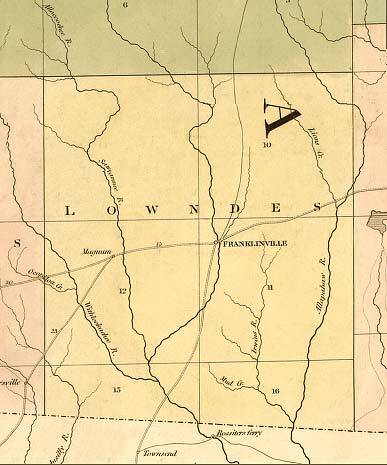
Lowndes County, 1839, GeorgiaInfo, GeorgiaInfo, “Map of Georgia & Alabama exhibiting the post offices, post roads, canals, rail roads & c. By David H. Burr. (Late topographer to the Post Office.) Geographer to the House of Representatives of the U.S.” From his The American Atlas (London, J. Arrowsmith, 1839) . Franklinville appears on an unnamed river, the Little River is marked as “Sawannee R.” with a town called “Magnes” on it, Okapilco Creek is marked as “Withieckochee R.” (or something like that), and some tributary of it is marked “Ocopilco Cr.” I’m proud to see Tom’s Branch, which runs through my property, is clearly drawn, albeit unnamed, with its confluence just south of Franklinville Road. A road south from Franklinville goes to “Townsend” in Madison County, Florida, and on a road east of that there’s a “Rossiter’s Ferry” on the Withlacoochee in Hamilton County. Also, Grand Bay Creek is marked “Irwins R.”, flowing into the “Allapahaw R.”Loco2 | | Troupville, GA | | 29 January 1889 | |
|