March 8, 2019 PDF and Context
To: EPD.Comments@dnr.ga.gov
Elizabeth Booth, Environmental Protection Division
Watershed Protection Branch,
Watershed Planning & Monitoring Program,
Suite 1152 East, 2 Martin Luther King, Jr., Dr., Atlanta, GA 30334
Cc: Victoria Adams <Victoria.Adams@dnr.ga.gov>, 404-463-4955
Re: Water Quality Standards 2019 Triennial Review
https://epd.georgia.gov/triennial-review-water-quality-standards#_TR_2019
Dear EPD,
I write to request three changes in the 2019 Triennial Review:
- All rivers and many lakes and swamps in the Suwannee River Basin should be designated Recreational, not Fishing.
- Boating, especially in paddle craft such as canoes, kayaks, and paddleboards, should be considered primary recreation, not secondary.
- Water quality standards should be the same year-round, not lower in winter.
Point 1: Recreational designation for the Suwannee River Basin.
- WWALS schedules at least one paddle outing each month; often two or three. http://wwals.net/events-2/outings-events/
- Numerous individuals, families, and clubs fish and paddle on our rivers and other waterbodies in every month of the year, plus cave diving in our springs.
- People come from as far as south Florida and Canada to paddle on our rivers.
- Canadians shivering on the Suwannee River in Echols County on a cold March 2017 winter day came back again. http://wwals.net/?p=42583

- Three kayakers from south Florida paddled our Withlacoochee River from our most upstream water trail landing downstream into Florida.
- A kayaker from the Atlantic coast of Florida won our Sixth Annual BIG Little River Paddle Race in 2018, finishing on Reed Bingham State Park Lake.
- Paddle Georgia will bring about 300 paddlers from Georgia, Florida, and beyond to our Withlacoochee River in June 2019. http://wwals.net/?p=48289
- There are water trails on all the main rivers of the Suwannee River Basin in Georgia: the Suwannee, Alapaha, Withlacoochee, and Little, including several lakes, as well as in the Okefenokee Swamp. http://wwals.net/blog/water-trails/
- These water trails are encouraging more people to paddle on our rivers, lakes, and swamps, improving the cleanliness of our waters and the safety of boating. See for example the unsolicited testimonial from Lanier County Emergency Management, “Alapaha River Beauty should Not be Hidden.” http://wwals.net/?p=43742
- The Suwannee, Alapaha, and Withlacoochee Rivers have mercury TMDLs that limit fish consumption, so Fishing seems an inappropriate classification.
Point 2: Boating should be considered primary contact recreation.
Your slide 5, DESIGNATED USES, for the February 2019 Public Hearing, lists:
- Drinking Water
- Recreation – Primary Contact

- Fishing - Propagation of Fish, Shellfish, Game and Other Aquatic Life and Secondary Recreation
- Primary Trout
- Secondary Trout
- Warmwater
- Coastal Fishing
- Wild River
- Scenic River
From our south Georgia perspective, this seems a very strange ordering. All our streams are warm water, which is why people fish in them year-round for catfish, bass, and bream.
People also boat on our waters year-round, largely because they are warm water.
In our Suwannee River Basin rivers, and in many others in the state of Georgia, boating, especially paddle boating, involves direct contact with the water.

- Water drips from the paddle.
- Getting in or out of the boat often involves wading.
- Every WWALS outing is also a cleanup, involving retrieving trash into the boat, along with some water.
- In warm weather, boaters often swim during a paddle.
- Because of overhanging branches, deadfalls, shoals, and other reasons, falling in is so common in every season of the year that WWALS even has a Fallers Award. Pictured are two such award winners, from our 2018 BIG Little River Paddle Race.
Thus warm water should be considered a reason for listing streams, lakes, and swamps as “Recreation – Primary Contact” and all our streams and waterbodies in the Suwannee River Basin should be so listed.
Point 3: year-round water quality standards
Thank you for this listing in your presentation slides from the February 2019 Public Hearing:
- Big Creek/Laura S. Walker Lake should be in the Satilla Basin
Indeed, the southeast side of the Okefenokee Swamp is in the Satilla and St Marys River Basins, while the rest is in the Suwannee River Basin. This distinction is common knowledge among those of us who live in south Georgia.
As Suwannee Riverkeeper, I report that people boat in the Okefenokee Swamp and the Suwannee River every month of the year, as well as on the Alapaha, Little, and Withlacoochee Rivers, and on Banks Lake and Reed Bingham State Park Lake. They also fish, swim, and dive in November through April, when the current Georgia Bacterial Standards are lower. https://adoptastream.georgia.gov/sites/adoptastream.georgia.gov/files/related_files/document/B_Ch_1.pdf.
For seven years, we have held our BIG Little River Paddle Race in April, and last year we held a new WWALS Boomerang Paddle Race in November on the Withlacoochee River.
Boating, swimming, fishing, and diving are economic advantages
In addition to the environmental benefits of clean waters. The WWALS water trails have letters of support from tourism authorities, chambers of commerce, city councils, and county commissions, attesting to the economic advantages of water trails. Several county Comprehensive Plans, including those for Lowndes and Brooks Counties, also attest to the economic value of our waters and water trails. http://wwals.net/blog/water-trails/
There are not many cleaner economic benefits, and few requiring less public investment. The entire Suwannee River Basin is above the porous coastal plain limestone that contains the Floridan Aquifer, which is the source of all our drinking water, irrigation for agriculture, water for industry. River water interchanges with groundwater, so river water quality is essential for everything here, from boating to brewing beer. Please reclassify our rivers as Recreational, and update the Georgia Bacterial Standards to be the same year-round.
Sincerely,
John S. Quarterman,
Suwannee Riverkeeper,
WWALS Watershed Coalition
850-290-2350, 229-242-0102
contact@suwanneriverkeeper.org
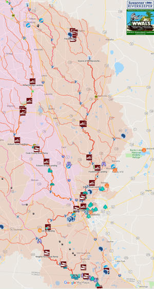
Attachments: Map of Landings on all Suwannee River Basin Rivers in Georgia
Criteria for Changing Recreational Use for:
Suwannee River, Okefenokee Swamp
Alapaha River, Lake Irma, Banks Lake, Grand Bay
Withlacoochee River
Little River, Reed Bingham State Park Lake
Map of Landings on all Suwannee River Basin Rivers in Georgia
(PDF)
This map shows most of the landings on the largest rivers in the Suwannee River Basin in Georgia, with their sub-basins color-coded, from east to west: Suwannee, Alapaha, Withlacoochee, and Little. Not all landings can be depicted at this scale; see the maps for the individual rivers, swamps, and lakes. https://www.google.com/maps/d/u/0/viewer?mid=1dnRr3ATEwReknyLZq26-316FfydbER2K
The rest of the attachments each address each of the required criteria for changing a use classification:
- Name and length of the waterbody.
- Location of the reach, shown on a map.
- Any 305(b)/303(d) impairment(s) &/or TMDL(s).
- Current users of the waterbody, including but not limited to
- businesses or industries,
- parks within the waterbody and watershed,
- and any “blue trails” on the water for water-craft recreation activities.
- Letters of support from:
- dischargers, domestic &/or industrial, to the reach.
- municipalities, county Board of Commissioners, other affected governmental bodies, and other stakeholders who live in the watershed.
- Investments, both completed and pending, for improved use of the waterbody such as boat ramps, parks, trails, or drinking water systems. Include the amount of the investment, as well as who funded the project(s) and for what purpose.d
Suwannee River, changing its Designated Use to Recreational (PDF)
- Name and length of the waterbody.
Suwannee River. Of its 250 miles, about 35 miles are in Georgia, plus its three branches in the Okefenokee Swamp.
- Location of the reach, shown on a map.
See also http://wwals.net/maps/suwannee-river-wilderness-trail/
- Any 305(b)/303(d) impairment(s) &/or TMDL(s).
- Current users of the waterbody, including but not limited to
- businesses or industries,
- parks within the waterbody and watershed,
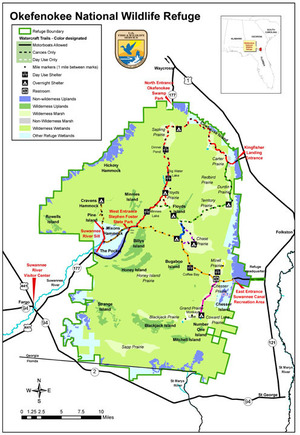
- GA DNR’s Stephen C. Foster State Park is located on the Suwannee River within
- the Okefenokee National Wildlife Refuge (designated by Congress in 1936 and managed by the U.S. Fish and Wildlife Service, USFWS),
- as is the Okefenokee Wilderness (designated by Congress in 1974 and also managed by USFWS).
- and any “blue trails” on the water for water-craft recreation activities.
- dischargers, domestic &/or industrial, to the reach.
See next bullet point (stakeholders) for Fargo, Clinch County, Waycross, Echols County, and Valdosta.
- municipalities, county Board of Commissioners, other affected governmental bodies, and other stakeholders who live in the watershed.
- Fargo, in Clinch County, is at the access road to the Okefenokee, with numerous references to that swamp.
- Waycross, part of which is in the Suwannee River Basin, in Ware County, bills itself as Gateway to the Okefenokee.
- Valdosta, in Lowndes County, the biggest city in the Suwannee River Basin, advertises itself as a route to the Okefenokee, and there are signs on I-75 indicating that.
- The Adopted 2015 Joint Clinch County and Cities of Argyle, Du Pont, Fargo, and Homerville Comprehensive Plan Update says “Encourage private operators to explore opportunities for tourism on the Okefenokee and the Suwannee River. The advertising of natural resources and the Eco-Lodge could increase environmental tourism and environmental research…. In collaboration with the Department of Natural Resources, continue to conduct a marketing campaign to promote the Suwannee River Eco-Lodge and golf course packages…. Build a boardwalk to connect businesses to the Suwannee River Eco-Lodge.” https://www.sgrc.us/documents/localgovernmentservices/comprehensiveplans/4d34fa006d652aba24fe1ab27b3d61e2.pdf
- The 2015 Echols County Comprehensive Plan Update says “The Suwannee River, Grand Bay Creek, Alapahoochee River, and Toms Creek could possibly be utilized a lot for recreational and/or tourist uses.” https://www.sgrc.us/documents/localgovernmentservices/comprehensiveplans/033e0522f82ac2b2ea4cf26b71988d21.pdf
- Investments, both completed and pending, for improved use of the waterbody such as boat ramps, parks, trails, or drinking water systems. Include the amount of the investment, as well as who funded the project(s) and for what purpose.
There are boat ramps on the Suwannee River in Georgia at GA DNR’s Stephen C. Foster State Park in Charlton County and at Fargo in Clinch County at US 441. There is riverbank access at the Suwannee River Sill and at Griffis Fish Camp, both off of GA 177 between Fargo and the Park. See next section, on Okefenokee Park, for extensive investments.
Okefenokee Swamp, changing its Designated Use to Recreational (PDF)
- Name and length of the waterbody.
Okefenokee Swamp. About half of its 438,000 acres are in the Suwannee River Basin, and almost all of that is in Georgia.
- Location of the reach, shown on a map.
See also http://wwals.net/blog/maps/basin/
- Any 305(b)/303(d) impairment(s) &/or TMDL(s).
- Current users of the waterbody, including but not limited to
- businesses or industries,
- The Okefenokee Swamp is a world-renowned tourist attraction, with daily boat tours, overnight boat campers, and day trippers.
- Griffis Fish Camp, located on the Suwannee River just downstream of the swamp, does a thriving business with campers, boaters, and fishers.
- WWALS often organizes outings in the Okefenokee Swamp; see http://wwals.net/events-2/outings-events/
- See also attached letter from Georgia Beer Co.
- parks within the waterbody and watershed,
- GA DNR’s Stephen C. Foster State Park is located within
- the Okefenokee National Wildlife Refuge (designated by Congress in 1936 and managed by the U.S. Fish and Wildlife Service, USFWS),
- as is the Okefenokee Wilderness (designated by Congress in 1974 and also managed by USFWS).
- and any “blue trails” on the water for water-craft recreation activities.
- dischargers, domestic &/or industrial, to the reach.
See next bullet point (stakeholders) for Fargo, Clinch County, Ware County, and Lowndes County.
- municipalities, county Board of Commissioners, other affected governmental bodies, and other stakeholders who live in the watershed.
- Investments, both completed and pending, for improved use of the waterbody such as boat ramps, parks, trails, or drinking water systems. Include the amount of the investment, as well as who funded the project(s) and for what purpose.
GA DNR’s Stephen C. Foster State Park has a boat ramp, boat rental, boat tours, 9 cottages, 99 campsites, 1 primitive campground, 3 picnic shelters, a playground, and other outbuildings, https://gastateparks.org/StephenCFoster as well as the Suwannee River Eco-Lodge off of GA 441 north of Fargo. https://gastateparks.org/SuwanneeRiverEcoLodge
Okefenokee National Wildlife Refuge has numerous sleeping platforms on boating trails in the park, as well as a boardwalk and landing on Billy’s Island. https://www.fws.gov/refuge/okefenokee/
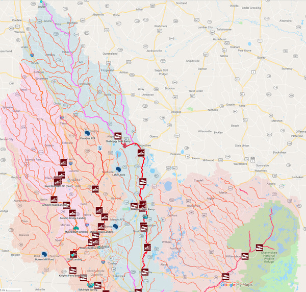
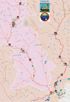
Alapaha River, changing its Designated Use to Recreational (PDF)
- Name and length of the waterbody.
Alapaha River. Of its 202 miles, 179 are in Georgia. Of the 129 miles on the WWALS Alapaha River Water Trail, 106 miles are in Georgia. At least the 106 miles from Sheboggy Boat Ramp (on US 82 east of Alapaha, GA) to the state line should be reclassified as Recreational. Reclassifying the entire 179 miles of the Alapaha River in Georgia would be better.
- Location of the reach, shown on a map.
See also http://wwals.net/maps/alapaha-water-trail/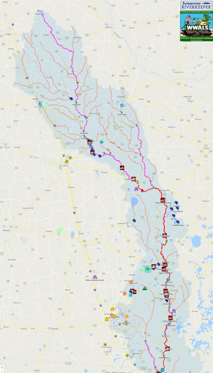
- Any 305(b)/303(d) impairment(s) &/or TMDL(s).
- Current users of the waterbody, including but not limited to
- businesses or industries,
- parks within the waterbody and watershed,
- Alapaha River Wildlife Management Area, south of US 319, east of the Alapaha River, between Tifton and Ocilla, in Irwin County. http://wwals.net/?p=22027
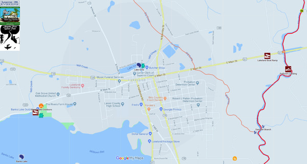
- Lakeland Boat Ramp at GA 122 aka GA 37 is advertised by the Lanier-Lakeland Chamber of Commerce among Parks & Trails. http://www.lakelandchamber.org/parks-trails.htm
- Pafford’s Landing slightly downstream from GA 122 is in a 19-acre tract owned by private nonprofit Lanier Parks Inc. and operated like a public park. http://wwals.net/?p=36369
- Grand Bay WMA (see separate writeup on Grand Bay, reclassify as Recreational Use)
- Naylor Boat Ramp, under construction by Lowndes County, is in a 4.35-acre park just upstream of US 84. http://wwals.net/?p=6425
- and any “blue trails” on the water for water-craft recreation activities.
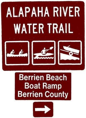
The WWALS Alapaha River Water Trail has eleven river landings in Georgia. http://wwals.net/maps/alapaha-water-trail/
- dischargers, domestic &/or industrial, to the reach.
See next bullet item (stakeholders) for Valdosta, Lowndes County, Berrien County, Lanier County, Atkinson County, and Echols County.
- municipalities, county Board of Commissioners, other affected governmental bodies, and other stakeholders who live in the watershed.
- 2014-11-05: Letter of support from Valdosta-Lowndes County Chamber of Commerce
- 2014-11-05: $500 check from Valdosta-Lowndes County Tourism Authority
- 2015-01-21: Letter of support from the Valdosta-Lowndes Development Authority
- 2016-09-14: Letter from Berrien County authorizing WWALS to put signs on county land at landings in Berrien County. In a letter to WWALS about that, the county named all four of those landings with names suggested by WWALS. Three of them are on the Alapaha River. http://wwals.net/?p=43927
- 2018-01-08: Resolution of support from the Lanier County, Georgia Board of Commissioners
- 2018-01-18: Resolution of support from the Atkinson County, Georgia Board of Commissioners
- 2018-03-06: Berrien County Commission vote to rename two landings to become Sheboggy Boat Ramp and Berrien Beach Boat Ramp.
- 2018-04-05: Resolution of support from Valdosta Mayor and City Council.
- 2018-04-07: “Alapaha River Beauty should Not be Hidden,” unsolicited video testimonial by Lanier County Emergency Management. http://wwals.net/?p=43742
- Lowndes County is building Naylor Boat Ramp at US 84, will be planting road signs there when it’s complete.
- The 2015 Echols County Comprehensive Plan Update says “The Alapaha River flows north to south on the west side of the County and has 1 boat ramp with a second under construction. This information needs to be placed in the State Tourism Brochure as one of the cleanest rivers to attract visitors.... The public boat ramp located on the Alapaha River is valuable and could be better used as an asset to the community. The addition of the second boat ramp could create a loop to attract more tourists.” https://www.sgrc.us/documents/localgovernmentservices/comprehensiveplans/033e0522f82ac2b2ea4cf26b71988d21.pdf
- The 2016 Greater Lowndes Comprehensive Plan lists the Alapaha River and Grand Bay Wildlife Management Area and Wetland Education Center among “Important parts of the local economy which should be better promoted and utilized”. https://www.lowndescounty.com/DocumentCenter/View/1512/2016-Greater-Lowndes-Comprehensive-Plan-PDF
- 2015 Joint Berrien County Comprehensive Plan Update For Berrien County And The Cities of Alapaha, Enigma, Nashville and Ray City, says “Coordinate with the Georgia Department of Natural Resources, the Georgia Department of Transportation and other applicable state agencies to establish more public access points along the Alapaha River.” https://www.sgrc.us/documents/localgovernmentservices/comprehensiveplans/7f2ae9ce012196e973473969fe4f2c46.pdf
- The 2018 Joint Comprehensive Plan Update, Atkinson County, The City of Pearson & City of Willacoochee, says “The Alapaha and Satilla Rivers could support a canoe and kayak rental business.” https://www.dca.ga.gov/sites/default/files/atkinson_county_w_cities_of_pearson_and_willacoochee_plan_update_2018.pdf
- Investments, both completed and pending, for improved use of the waterbody such as boat ramps, parks, trails, or drinking water systems. Include the amount of the investment, as well as who funded the project(s) and for what purpose.
There are four public boat ramps on the Alapaha River in Georgia, and another being constructed: http://wwals.net/maps/alapaha-water-trail/
- Sheboggy Boat Ramp, at the US 82 bridge east of Alapaha in Berrien County, with concrete recently repoured by Berrien County for $2,000 plus labor. *
- Berrien Beach Boat Ramp, on GA 168, northeast of Nashville in Berrien County, apparently maintained by the Georgia Department of Transportation (GDOT). *
- Lakeland Boat Ramp, on GA 122, east of Lakeland in Lanier County, maintained by GDOT. *
- Naylor Boat Ramp, upstream of US 84 in Lowndes County, being constructed by Lowndes County, using funds approved by the voters of Lowndes County in the 2013 SPLOST election, plus labor supplied by the county.
- Statenville Boat Ramp, on GA 94 west of Statenville in Echols County, maintained by GA DNR. *
In addition there are six public riverbank landings:
- Nashville Landing, at GA 135, east of Nashville in Berrien County, maintained by Berrien County. *
- Willacoochee Landing, at GA 135, south of Willacoochee, in Atkinson County, maintained by Atkinson County. *
- Pafford’s Landing, south of GA 122, east of Lakeland, in Lanier County, owned by private Lanier Parks Inc. *
- Burnt Church Landing, off of GA 135, south of Lakeland, in Lanier County, owned by Lanier County.
- Hotchkiss Road Landing, on Hotchkiss Road north of US 84, in Lanier County. *
- Mayday Landing, on Howell Road, in Echols County, maintained by Echols County. *
* WWALS paid approximately $3,000 for water trail signs at these nine locations on the Alapaha River. At each location, there is a pair of signs (one for each direction of approach). Each pair of signs has three parts on the same pole: a sign saying Alapaha River Water Trail and with appropriate icons, a sign naming the landing and the county, and a directional arrow.
Lowndes County has promised to make and plant road signs at Naylor Boat Ramp when it is completed.
Lake Irma, changing its Designated Use to Recreational (PDF)
- Name and length of the waterbody.
Lake Irma, about 12 acres in Lakeland, Georgia.
- Location of the reach, shown on a map.
- Any 305(b)/303(d) impairment(s) &/or TMDL(s).
Apparently none.
- Current users of the waterbody, including but not limited to
- businesses or industries,
The Lanier-Lakeland Chamber of Commerce advertises Lake Irma as an attraction. http://www.lakelandchamber.org/parks-trails.htm
WWALS participated in the 2nd Annual Flatlander Canoe and Kayak Race, 5 October 2014. http://wwals.net/?p=3764
- parks within the waterbody and watershed,
Lake Irma and the land around it is a Lakeland city park, along with the nearby Robert Simpson Nature Trail, advertised on the Chamber of Commerce website. http://www.lakelandchamber.org/parks-trails.htm
- and any “blue trails” on the water for water-craft recreation activities.
The WWALS Alapaha River Water Trail includes Lake Irma. http://wwals.net/maps/alapaha-water-trail/
- dischargers, domestic &/or industrial, to the reach.
See next bullet item (stakeholders) for Lanier County.
- municipalities, county Board of Commissioners, other affected governmental bodies, and other stakeholders who live in the watershed.
All those who endorsed the Alapaha River Water Trail, especially Lanier County. See Alapaha River.
- Investments, both completed and pending, for improved use of the waterbody such as boat ramps, parks, trails, or drinking water systems. Include the amount of the investment, as well as who funded the project(s) and for what purpose.
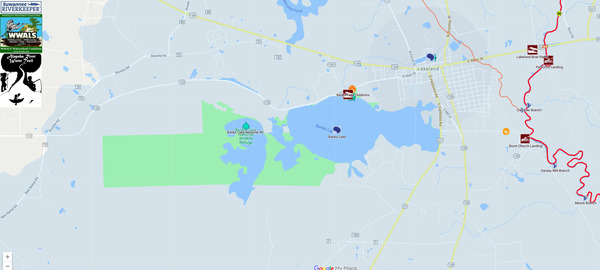
Banks Lake, changing its Designated Use to Recreational (PDF)
- Name and length of the waterbody.
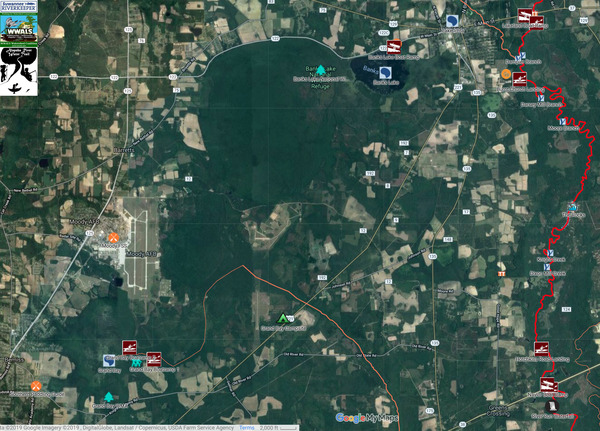
Banks Lake. 4,049 acres in Banks Lake National Wildlife Refuge.
- Location of the reach, shown on a map.
- Any 305(b)/303(d) impairment(s) &/or TMDL(s).
MERCURY AND FISH CONSUMPTION GUIDELINES DUE TO MERCURY TMDL http://epd.georgia.gov/sites/epd.georgia.gov/files/tmdl/TMDL_Implementation_Plans/SouthGA4_ProgramPlans/TMDLIP_SouthGA4_FCG_Hg_Y2002.pdf
- Current users of the waterbody, including but not limited to
- businesses or industries,
“Night fishing is allowed. Fishing tournaments require a special use permit and privately-sponsored bass tournaments are held frequently year-round. Largemouth bass is the most popular sport fish, and ten-pounders are occasionally caught. Other favorites are speckled perch (crappie), bream (bluegill), and catfish.”
- parks within the waterbody and watershed,
Banks Lake National Wildlife Refuge is managed as part of the Okefenokee Complex by the U.S. Fish and Wildlife Service, along with Okefenokee National Wildlife Refuge. https://www.fws.gov/refuge/Okefenokee/About_the_Complex.html
- and any “blue trails” on the water for water-craft recreation activities.
The WWALS Alapaha River Water Trail includes Banks Lake. http://wwals.net/maps/alapaha-water-trail/
- dischargers, domestic &/or industrial, to the reach.
See next bullet item (stakeholders) for Lanier County.
- municipalities, county Board of Commissioners, other affected governmental bodies, and other stakeholders who live in the watershed.
All those who endorsed the Alapaha River Water Trail, especially Lanier County. See Alapaha River.
Georgia Tourism: https://www.exploregeorgia.org/lakeland/outdoors-nature/bird-watching/banks-lake-national-wildlife-refuge
- Investments, both completed and pending, for improved use of the waterbody such as boat ramps, parks, trails, or drinking water systems. Include the amount of the investment, as well as who funded the project(s) and for what purpose.
“Facilities at Banks Lake NWR include restrooms, boat ramp, short walking trail, boardwalk and platform, and accessible fishing dock. Night fishing is permitted, and there is no launch fee. The concession operation, Banks Lake Outdoors, has canoe and kayak rentals and a place to buy your bait before you launch your boat!”
https://www.fws.gov/refuge/Banks_Lake/visit/visitor_activities.html
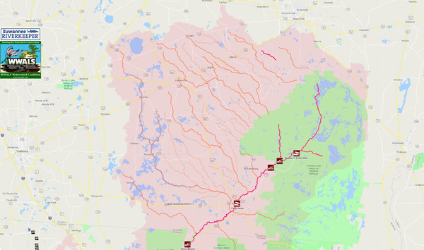
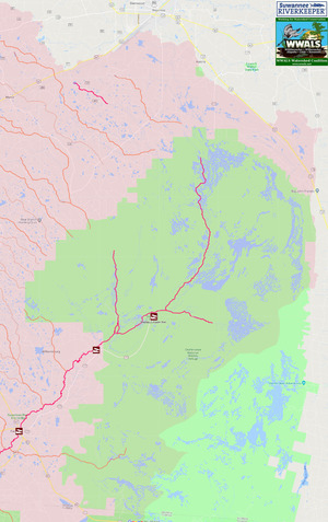
Grand Bay, changing its Designated Use to Recreational (PDF)
- Name and length of the waterbody.
Grand Bay. “The Grand Bay Wildlife Management Area (WMA) encompasses 2,623 acres of state-owned property and 5,874 acres of land under license from the U.S. Air Force.”
- Location of the reach, shown on a map.
See also http://wwals.net/maps/alapaha-water-trail/
- Any 305(b)/303(d) impairment(s) &/or TMDL(s).
None known. However, Moody Air Force Base leaked toxic firefighting foams (per- and polyfluorinated alkyl substances or PFASs),) at numerous locations upstream of Grand Bay. http://wwals.net/?p=48001
- Current users of the waterbody, including but not limited to
- businesses or industries,
- parks within the waterbody and watershed,
- GA DNR’s Grand Bay Wildlife Management Area (WMA)
- and any “blue trails” on the water for water-craft recreation activities.
The WWALS Alapaha River Water Trail includes Grand Bay. http://wwals.net/maps/alapaha-water-trail/
- dischargers, domestic &/or industrial, to the reach.
- See next bullet item (stakeholders) for Lowndes County and Lanier County.
- municipalities, county Board of Commissioners, other affected governmental bodies, and other stakeholders who live in the watershed.
All those who endorsed the Alapaha River Water Trail, especially Lowndes County and Lanier County. See Withlacoochee River.
The 2016 Greater Lowndes Comprehensive Plan lists Grand Bay Wildlife Management Area and Wetland Education Center among “Important parts of the local economy which should be better promoted and utilized”. https://www.lowndescounty.com/DocumentCenter/View/1512/2016-Greater-Lowndes-Comprehensive-Plan-PDF
- Investments, both completed and pending, for improved use of the waterbody such as boat ramps, parks, trails, or drinking water systems. Include the amount of the investment, as well as who funded the project(s) and for what purpose.
GA DNR’s Grand Bay Wildlife Management Area has two boat ramps, primitive camping, extensive boardwalk, observation tower, hiking trails, and educational center. It lists canoeing first among activities, along with lake fishing. https://georgiawildlife.com/grand-bay-wma
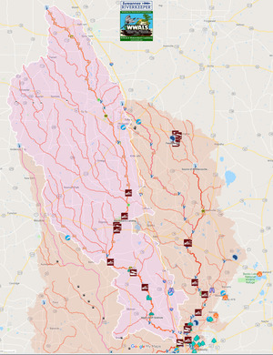
Withlacoochee River, changing its Designated Use to Recreational (PDF)
- Name and length of the waterbody.
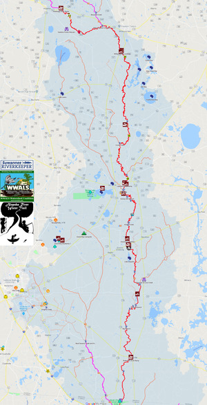
Withlacoochee River. Of its 115 miles from Berrien County to the Suwannee River in Florida, 87 miles are in Georgia. Of the 97.7 miles of this river in the Withlacoochee and Little River Water Trail (WLRWT), 70 miles are in Georgia, from GA 37 between Adel and Ray City past Valdosta, Quitman, and Clyattville to the state line. At least those 70 miles of the Withlacoochee River on the WLRWT in Georgia should be reclassified as Recreational. Reclassifying the entire Withlacoochee River in Georgia would be better.
See also http://wwals.net/maps/withlacoochee-river-water-trail/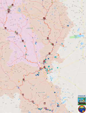
- Any 305(b)/303(d) impairment(s) &/or TMDL(s).
- Current users of the waterbody, including but not limited to
- businesses or industries,
- See attached letter from Georgia Beer Co., Valdosta, GA.
- Southern Paddling Guide, between Moody AFB and Valdosta in Lowndes County, GA, at the top of Cherry Creek, rents boats and guides excursions.
- FOSS at Moody Air Force Base rents boats (military or veterans only), in Lowndes County, GA, between the Withlacoochee and Alapaha Rivers.
- CORE at Valdosta State University rents boats (renter must have some association with the university) in Lowndes County, GA, near the Withlacoochee River.
- Valdosta, the biggest city in the Suwannee River Basin, is located on the Withlacoochee River.
- Tifton, the second biggest city, is at the headwaters of its tributary the New River.
- Moultrie, the third biggest city, is at the headwaters of Okapilco Creek,
- which flows past Quitman into the Withlacoochee River.
- Adel is on a tributary of the Withlacoochee River, and Cook County is bounded by the Little River on the west and the Withlacoochee and New Rivers on the east.
- Similarly, Lowndes County’s west border is the Little River and the Withlacoochee River.
- WWALS organizes frequent paddle outings on the Withlacoochee River; see http://wwals.net/events-2/outings-events/
- parks within the waterbody and watershed,
- and any “blue trails” on the water for water-craft recreation activities.
The WWALS Withlacoochee and Little River Water Trail has nineteen landings on those rivers in Georgia, of which ten are on the Withlacoochee River. http://wwals.net/maps/withlacoochee-river-water-trail/
- dischargers, domestic &/or industrial, to the reach.
See next bullet item (stakeholders) for Brooks County, Adel, Hahira, and Valdosta.
- municipalities, county Board of Commissioners, other affected governmental bodies, and other stakeholders who live in the watershed.
- Valdosta – Lowndes Tourism Authority: $500
- 2016-09-14: Letter from Berrien County authorizing WWALS to put signs on county land at landings in Berrien County. In a letter to WWALS about that, the county named all four of those landings with names suggested by WWALS. One of them is Ray City Landing on the Withlacoochee River at GA 76. http://wwals.net/?p=43927
- 2016-11-07 Brooks County, GA: resolution, http://wwals.net/?p=27495
- 2018-01-16 Adel, GA: resolution, http://wwals.net/?p=41284
- 2018-02-01 Hahira, GA: resolution, http://wwals.net/?p=42023
- 2018-02-20 Valdosta-Lowndes Development Authority letter of support, http://wwals.net/?p=42452
- 2018-04-05 Valdosta City Council: resolution, http://wwals.net/?p=43297
- The Final adopted 2018 Comprehensive Plan Update for Tift County and the Cities of Omega, Tifton, and Ty Ty says “Greater Tift County’s natural resources should be marketed by the Tourism Department to increase economic and tourism opportunities in the community. Assets of the community are the Little River Corridor, the New River Corridor, Southside Branch and Westside Branch Rivershed, and Ty Ty Creek…. 1.2 Sustainable areas need to be set aside for 2 boat paddle trails. Policy 1.2.1: Encourage public and private participation and partnerships between all communities in Tift County and including the State to work on opportunities for river access.” https://www.sgrc.us/documents/localgovernmentservices/comprehensiveplans/0ff1e13346601ed599dc6c6f356003fb.pdf
- The 2016 Greater Lowndes Comprehensive Plan lists the Withlacoochee River among “Important parts of the local economy which should be better promoted and utilized”. https://www.lowndescounty.com/DocumentCenter/View/1512/2016-Greater-Lowndes-Comprehensive-Plan-PDF
- The Adopted 2017 Joint Brooks County and Cities of Barwick, Morven, Pavo, and Quitman Comprehensive Plan Update says “Brooks County can boast three springs of a type usually thought to be only in Florida. Of only about six second magnitude springs in Georgia, three are downstream from US 84: Wade or Blue Springs, sadly defunct; McIntyre Spring, large and easily accessible in the right bank emerging from 4610 feet of caverns back under Brooks County; and Arnold Springs, actually three small springs in the left bank. Second magnitude springs average 10 to 100 cubic feet per second (cfs) of discharge. While they are widespread in north Florida, apparently there are only about six in Georgia [1]. Since the county line is on the east bank, all three springs in the Withlacoochee River are in Brooks County. (There is only one first magnitude spring (more than 100 cfs) in Georgia, Radium Springs near Albany.) The biggest is McIntyre Spring, next to the west or right bank, with about 46.42 cfs[1], about river mile 31.46. Cave diver Guy Bryant says he and others have explored it with scuba gear 4610 feet back under Brooks County. Land access to McIntyre Spring is privately owned and closed, but the spring itself is readily accessible in the river. Smallest is the cluster of three springs known as Arnold Springs, on the north or left bank, at 30.641185, - 83.336079, about river mile 29.06, owned by a family corporation based in Valdosta. The most famous, Blue or Wade Spring just south of US 84 and the railroad tracks and north of Blue Springs Road, was once a famous resort, with a custom-built railroad. It was actually two springs, one inland at the resort and one in the river, measured in 1937 at 19.9 and 23.21 cfs[1]. The past tense is because according to a reliable source attempts to improve the spring by digging it out destroyed it.” https://www.sgrc.us/documents/localgovernmentservices/comprehensiveplans/7a3d5e53cf7beb85f963e3463c07c193.pdf
- Investments, both completed and pending, for improved use of the waterbody such as boat ramps, parks, trails, or drinking water systems. Include the amount of the investment, as well as who funded the project(s) and for what purpose.
In Georgia on the Withlacoochee River there are Youngs Mill Creek Landing on GA 37, with paved access by Cook County, and Ray City Landing at GA 37, which Berrien County agreed to name that and to authorize WWALS to plant signs.
Lowndes County has promised to make and plant road signs at all river landings in Lowndes County, which on the Withlacoochee River include Hagans Bridge Landing at GA 122, Franklinville Landing, Staten Road Landing, Langdale Park Boat Ramp (VLPRA) off of US 41, Sugar Creek Landing on Gornto Road, Knights Ferry Boat Ramp (VLPRA), Nankin Boat Ramp (VLPRA), and State Line Boat Ramp (GA DNR & VLPRA).
VLPRA: Valdosta-Lowndes County Parks & Recreational Authority.
Little River, changing its Designated Use to Recreational (PDF)
- Name and length of the waterbody.
The Little River runs 105 miles, all in Georgia, from its source near Ashburn to its confluence with the Little River just west of Valdosta. At least the 59 miles on the Withlacoochee and Little River Water Trail (WLRWT), from Kinard Bridge Landing west of Lenox to the Little River Confluence with the Withlacoochee River just downstream from Troupville Boat Ramp west of Valdosta, should be reclassified as Recreational. Better would be to reclassify the whole river.
- Location of the reach, shown on a map.
See also http://wwals.net/maps/withlacoochee-river-water-trail/
- Any 305(b)/303(d) impairment(s) &/or TMDL(s).
- Current users of the waterbody, including but not limited to
- businesses or industries,
- NWXpeditions, Pavo, Georgia, near the Little River in Brooks County, “No Worries Expeditions will take u canoeing and camping on the rivers of S Georgia and N Florida. We custom design the canoe trip of your dreams.” https://www.facebook.com/NWXExpeditions/
- Valdosta, the biggest city in the Suwannee River Basin, is located just east of the confluence of the Little River with the Withlacoochee River, and Tifton, the second biggest city, is just east of the Little River.. Hahira is located between the Little River and the Withlacoochee River.
- WWALS holds frequent paddle outings on the Little River; see http://wwals.net/events-2/outings-events/
- See also attached letter from Georgia Beer Co.
- parks within the waterbody and watershed,
- and any “blue trails” on the water for water-craft recreation activities.
The WWALS Withlacoochee and Little River Water Trail has nineteen landings in Georgia (see Withlacoochee River), of which nine are on the Little River, including two on Reed Bingham State Park Lake. http://wwals.net/maps/withlacoochee-river-water-trail/
The Sixth Annual BIG Little River Paddle Race in 2018 drew 49 paddlers in 43 boats, 29 male, 20 female, from 4 to 69 years old, from 10 watersheds, 15 counties, and two states (Georgia and Florida). http://wwals.net/?p=43850
- dischargers, domestic &/or industrial, to the reach.
See next bullet item (stakeholders) for Adel, Cook County, Tifton, Hahira, Valdosta, Lowndes County, and others.
- municipalities, county Board of Commissioners, other affected governmental bodies, and other stakeholders who live in the watershed.
- All those who adopted resolutions supporting the Withlacoochee and Little River Water Trail, including Adel, Brooks County, Hahira, and Valdosta, or otherwise endorsed it; see Withlacoochee River.
- The Final adopted 2018 Comprehensive Plan Update for Tift County and the Cities of Omega, Tifton, and Ty Ty says “Greater Tift County’s natural resources should be marketed by the Tourism Department to increase economic and tourism opportunities in the community. Assets of the community are the Little River Corridor, the New River Corridor, Southside Branch and Westside Branch Rivershed, and Ty Ty Creek…. 1.2 Sustainable areas need to be set aside for 2 boat paddle trails. Policy 1.2.1: Encourage public and private participation and partnerships between all communities in Tift County and including the State to work on opportunities for river access.” https://www.sgrc.us/documents/localgovernmentservices/comprehensiveplans/0ff1e13346601ed599dc6c6f356003fb.pdf
- The Adopted 2015 Joint Cook County and Cities of Adel, Cecil, Lenox, and Sparks Comprehensive Plan Update says “Continue to assist the State and public/private groups in the protection of Reed Bingham State Park and other conservation areas, through in-kind services including but not limited to the river cleanup crew, publishing event notices, and Friends of Reed Bingham participation.” https://www.sgrc.us/documents/localgovernmentservices/comprehensiveplans/271aa30b87b2b45a73b3ae4f27818629.pdf
- The 2016 Greater Lowndes Comprehensive Plan lists the Little River among “Important parts of the local economy which should be better promoted and utilized”. https://www.lowndescounty.com/DocumentCenter/View/1512/2016-Greater-Lowndes-Comprehensive-Plan-PDF
- Investments, both completed and pending, for improved use of the waterbody such as boat ramps, parks, trails, or drinking water systems. Include the amount of the investment, as well as who funded the project(s) and for what purpose.
GA DNR has four boat ramps on the Little River: Reed Bingham State Park Boat Ramp (West in Colquitt County and East in Cook County), Cook County Boat Ramp, and Troupville Boat Ramp in Lowndes County. Cook County also has Kinard Bridge Landing near Lenox, upstream from RBSP, and Antioch Road Landing between RBSP and Cook County Boat Ramp. Colquitt County also has Adel-Moultrie Landing on GA 37 just downstream from the RBSP Lake Dam.
Lowndes County has promised to make and plant road signs at all river landings in Lowndes County, which on the Little River are Folsom Bridge Landing at GA 122 and Troupville Boat Ramp (GA DNR & VLPRA). Valdosta through VLPRA funded significant improvements to the access road to Troupville Boat Ramp.
VLPRA: Valdosta-Lowndes County Parks & Recreational Authority.
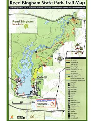
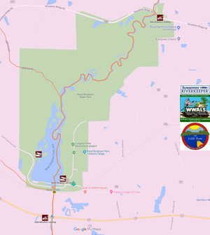
Reed Bingham State Park Lake, changing its Designated Use to Recreational (PDF)
- Name and length of the waterbody.
Reed Bingham State Park Lake. According to GA DNR: http://explore.gastateparks.org/info/94
“A 375-acre lake is popular with boaters and skiers, and fishing for bass, crappie, catfish and bream is excellent. Paddlers can rent canoes and kayaks to explore this beautiful lake lined with fragrant water lilies and tupelo trees. Guided pontoon boat tours are sometimes offered during events. The beachside pavilion, picnic shelters and group shelters are scenic spots for parties, reunions and other celebrations. Reed Bingham is less than six miles from I-75, making it a relaxing stop for travelers. It was named for Amos Reed Bingham who was instrumental in having the park established.
“Visitors to this pretty park usually see abundant wildlife, including species such as gopher tortoises, yellow bellied sliders and indigo snakes. Nesting bald eagles are often seen in winter. American alligators are often seen sunning along the lake’s edge. During winter, thousands of “buzzards,” actually black vultures and turkey vultures, roost in the trees and soar overhead. Nearly 80 percent of the Coastal Plain’s plant community can be found along the park’s Coastal Plain Nature Trail, making this park’s habitat some of the most diverse in the country.”
- Location of the reach, shown on a map.
https://gastateparks.org/sites/default/files/parks/pdf/reedbingham/ReedBingham_OrienteeringMap.pdf
- Any 305(b)/303(d) impairment(s) &/or TMDL(s).
- Current users of the waterbody, including but not limited to
- businesses or industries,
- Reed Bingham State Park and its Lake are featured in festivals and tourism and economic marketing by Cook County, Adel, Colquitt County, Moultrie, and other nearby cities and counties, as well as by the state of Georgia.
- WWALS conducts its annual BIG Little River Paddle Race on the Little River and Reed Bingham State Park Lake.
- See also attached letter from Georgia Beer Co.
- parks within the waterbody and watershed,
Reed Bingham State Park. http://explore.gastateparks.org/info/94
- and any “blue trails” on the water for water-craft recreation activities.
The WWALS Withlacoochee and Little River Water Trail includes the two GA DNR boat ramps on Reed Bingham State Park Lake and Red Roberts Landing, upstream on the Little River from that Lake, and still within the Park. http://wwals.net/maps/withlacoochee-river-water-trail/
The WWALS and FORB Sixth Annual BIG Little River Paddle Race in 2018 drew 49 paddlers in 43 boats, 29 male, 20 female, from 4 to 69 years old, from 10 watersheds, 15 counties, and two states (Georgia and Florida). http://wwals.net/?p=43850
- dischargers, domestic &/or industrial, to the reach.
See next bullet item (stakeholders) for Adel and Cook County.
- municipalities, county Board of Commissioners, other affected governmental bodies, and other stakeholders who live in the watershed.
- Investments, both completed and pending, for improved use of the waterbody such as boat ramps, parks, trails, or drinking water systems. Include the amount of the investment, as well as who funded the project(s) and for what purpose.
GA DNR has two boat ramps on Reed Bingham State Park Lake and Red Roberts Landing upstream on the Little River, as well as the rest of the state park itself, with all its buildings, roads, and staff.