Tag Archives: Little River

Sabal Trail maps digitized

Update 2019-03-19: The google map now includes Florida Southeast Connection (FSC) and FPL’s Martin County to Riviera Beach (MR-RV) pipeline to the sea, which FPL in 2018 got FPSC and FERC to roll into FSC. See also Stop FERC Shirking LNG Oversight.
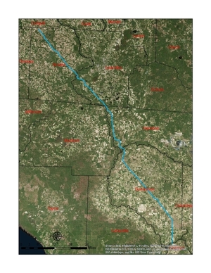
South Georgia and north Florida Update 2016-12-13: The google map now includes the Sabal Trail path digitized for all of Georgia and to the end of the line in Florida south of Orlando.

Update 2016-11-29: In the google map, extended the Sabal Trail alignment maps localized by LAKE for Mitchell, Colquitt, Brooks, and Lowndes Counties, Georgia, and Hamilton, Suwannee, and Gilchrist Counties, Florida to just north of Bell, FL, plus on the crowdsourcing map, WWALS aerials of Gilchrist County.

Update 2016-11-03: Added to the google map digitized path and maps for Gilchrist, Alachua, and part of Levy Counties, FL.

Update 2016-10-31: Added to the google map: Aerials: Suwannee, Ocholockonee, Withlacoochee, Santa Fe Rivers, Okapilco Creek, Sabal Trail Moultrie CY3-6 @ WWALS Southwings 2016-10-22.

Update 2016-10-30: The google map now has all Sabal Trail’s alignment maps from 7 April 2016 linked in for (part of Gilchrist 2016-11-29), Suwannee and Hamilton Counties, FL and Lowndes, Brooks, Colquitt, and Mitchell Counties, GA. Aerial pictures from the WWALS Southwings flight of October 22nd 2016 are also linked in, starting with US 84 HDD Withlacoochee River and US 129 HDD Santa Fe River.

Update 2016-09-14: All 527 alignment maps Sabal Trail filed with FERC in April 2016, in small, big, huge, and PDF formats, courtesy of Lowndes Area Knowledge Exchange (LAKE).

Update 2016-09-23: Added Depressions within 1 mile of Sabal Trail in Hamilton, Madison, and Suwannee Counties, Florida. The pipeline path doesn’t go through Madison County, but it comes closer than a mile, and not even two miles from Madison Blue Spring.

These maps show the path Sabal Trail is gouging its fracked methane pipeline through south Georgia and north Florida, with comparisons to some geological features, including Okapilco Creek, Withlacoochee River, Suwannee River, Suwannacoochee Spring, Falmouth Spring, the Cathedral Cave System, and numerous karstic features, some of them sinkholes.
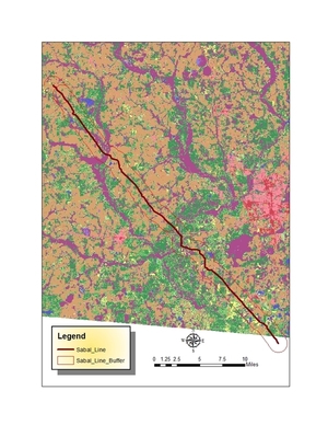
Brooks and Lowndes Counties, GA This digitizaiton is thanks to Continue reading

WWALS Outings, Rivers, and Pipeline on Chris Beckham drive-time radio WVGA 105.9 FM 8:00 7:30 AM 2016-09-02

8AM Friday morning WWALS will be on Chris Beckham’s drive-time radio show. WWALS president John S. Quarterman will be talking about Saturday morning’s Suwannee River paddle outing and other outings upcoming on the Alapaha and Withlacoochee Rivers, along with other developments on the Alapaha River Water Trail and the Withlacoochee and Little River Water Trail, along with many other things WWALS does. Plus what you can do about the FERC rubberstamp of the Sabal Trail fracked methane pipeline drilling under the Withlacoochee and Suwannee Rivers.

When: 8:00 7:30AM Friday September 2nd 2016

Where: Continue reading

Anhinga Trek on the Georgia Southern Rivers Birding Trail

Sites in WWALS watersheds include Paradise Public Fishing Area (PFA) at the headwaters of our Withlacoochee River, Reed Bingham State Park on our Little River, Grand Bay Wildlife Management Area (WMA) upstream from our Alapaha River, and Stephen C. Foster State Park at the headwaters of our Suwannee River in the Okefenokee Swamp, all on the Anhinga Trek of the Southern Rivers Birding Trail.

You can buy a license for any of these parks or WMAs from the state, and you can also see anhingas and other fascinating wildlife on our water trails.

Or come along on upcoming WWALS outings: Continue reading

Road Closures in 2009 Flood, Lowndes County, GA

Back in 2009, Lowndes County spent hundreds of times more in infrastructure repairs than the $40,000 that Valdosta is asking as a match to build an online flood warning map, beyond just fixing sewer system spills to dealing with the rest of the flooding problem. Map of roads closed At recent meetings, some County Commissioners seemed reluctant to authorize the request because the proposed map mostly covers subdivisions in Valdosta. But the entire county was affected by road closures in 2009, so maybe Commissioners could ask to expand the map to cover the whole county, which could also help find sources of the flooding problem. Sources and effects extend all the way to the edges of the county, as you can see in this a google map I built back then:

Roads closed in Lowndes County, Georgia, as of 9:38 a.m April 6th, according to the Valdosta Daily Times. This map shows locations and terrain. It’s a Google map, so it’s interactive: you can zoom and pan and change to satellite view, street map, street view, etc. Some of the locations are guesstimates from the cryptic descriptions in the VDT article. The one green blob is the one reopening mentioned in the article: “North Valdosta Road Withlacoochee River Bridge opened at 10 p.m. Sunday.”

That VDT article no longer seems to be online, but this one is. Jason Schaefer, VDT, 27 April 2013, What natural events cost Lowndes taxpayers, Continue reading

Winners of the BIG Little River Paddle Race 2016-05-21

Here are the winners of the Fourth Annual BIG Little River Paddle Race held Saturday May 21, 2016 at Reed Bingham State Park. Ready Including four time winner… see below.

On a fine Saturday morning, 34 people paddled, 18 male and 16 female, 19 in kayaks and 15 in canoes.

At this event to benefit Friends of Reed Bingham Park (FORB) and WWALS Watershed Coalition (WWALS), WWALS board member Bret Wagenhorst officiated as usual, this time assisted in handing out prizes by WWALS PR Committee member Amy Wiegenstein. Other board members of FORB and WWALS were present

Overall winner: Continue reading

Cave Diving Workshop, Lake City, 2016-05-21

If you can’t get to the BIG Little River Paddle Race Saturday at Reed Bingham State Park Saturday morning between Adel and Moultrie, GA, there’s a cave diving workshop in Lake City, FL. And yes, the Paddle Race is still on unless there’s actually lightning, hail, or torrential rain tomorrow morning, and so far that seems unlikely. But you can still paddle at Reed Bingham and go to the social in Lake City tonight, the afternoon part of the Workshop tomorrow, and the rebreather demonstration or spring tours Sunday.

What’s NCS-CDS? National Speleological Society, Cave Diving Section.

Social: 7PM Friday May 20th 2016 at 313 NW Commons Loop, Lake City, FL

Workshop: Continue reading

Video of Chris Beckham radio show about BIG Little River Paddle Race 2016-05-21

You are invited this Saturday morning to Reed Bingham State Park (between Adel and Moultrie) for a morning of sun, fun, cypress, turtles, and don’t pet the alligator at the fourth annual BIG Little River Paddle Race. You can register online (follow the link) or at the site (also follow the link for details). And Phil Hubbard’s special offer is still open: he will pay for two free registrations. If interested, send email wwalswatershed@gmail.com; first two received win.

Lots of prizes in numerous categories, including $100 for first prize. Plus Phil Hubbard also made and we have available the WWALS Fallers Plaque, which you may win if you inadvertently fall into the water. Thanks again to Bret Wagenhorst of Tifton for organizing the paddle race.

Here’s video of me talking about that on Chris Beckhams’s radio show, WVGA 105.9 FM the morning of May 16th: Continue reading

BIG Little River Paddle Race on Chris Beckham drive-time radio WVGA 105.9 FM 8:00 AM 2016-05-16

Update 2016-05-19: video of the radio interview, and don’t forget the paddle race is this Saturday!

Everybody listens to the radio in the car on the way to work, and Monday morning 8:00 AM I’ll be talking about the BIG Little River Paddle Race: community, water, trees, birds, fish, sunshine, and fun! $50 cash prize for first place, plus awards in numerous categories, or just paddle leisurely. It’s the fourth annual at Reed Bingham State Park, between Adel and Moultrie, on the border of Cook and Colquitt Counties, only 40 minutes from Valdosta. The Paddle Race is weekend after next, Saturday, May 21st, and you can sign up online or at the event. Before that, a radio show to talk about the paddle race.

When: 8:00AM Monday May 16th 2016

Where: 105.9 FM WVGA, Valdosta, Lowndes County, Georgia

What: Continue reading

Fixed: Access to GA 133 Little River Boat Ramp

Julie Bowland reports:

Boatramp Joy of joys! The humongous mud hole in the access road to the boat ramp off 133 across from the prison has finally been filled! And a sign calling it a park…could WWALS brochures be far behind?

This is the Little River Boat Ramp on the Withlacoochee and Little River Water Trail (WLRWT).

George Page, Executive Director of the Valdosta-Lowndes Parks & Rec Authority (VLPRA), told me it seems like a year or more ago that he had found funds to fix that access, and now I guess it’s happening.

It’s always been a park, listed under VLPRA as Continue reading

Map of American Rivers by Nelson Minar

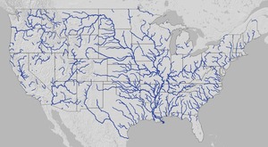
Here’s a map of all rivers in the U.S. by Nelson Minar. Lower 48 U.S. It actually covers the lower 48 states and is pretty impressive at that scale. Plus you can zoom in.

Gulf and south Atlantic

Here you can see rivers running to the Gulf start all the way up Continue reading