Tag Archives: WWALS

Streamer on the Suwannee, Alapaha, and Withlacoochee Rivers: ten or more rivers and many creeks, lakes, swamps, and ponds

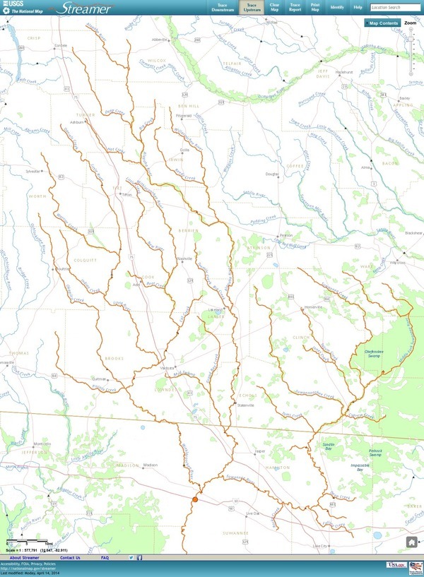
Update 3 March 2016: Suwannee River, ten rivers, and current location of USGS streamer.

The USGS Streamer interactive map shows all (well, most) tributaries of our two biggest WWALS rivers. Visitors sometimes refer to our “four rivers” since we only originally named four in our WWALS mission: Withlacoochee, Willacoochee, Alapaha, and Little. Yet we added the upper Suwannee, and there always were more than that: from one to ten rivers, depending on how you count them.

600x817 WWALS Rivers, in WWALS Rivers, by John S. Quarterman, for WWALS.net, 25 July 2015

The Withlacoochee River tributary map here shows the New River south of Tifton joining the Withlacoochee between Nashville and Adel.

Withlacoochee River Alapaha River

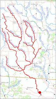
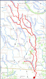
The New River is rather important, since it forms half of the boundary between Cook and Berrien Counties (the Withlacoochee River forms the other half): Continue reading

Request participation in watershed planning –WWALS to Corps

Unanimously approved 10 July 2013 by the WWALS board (PDF).

From:
WWALS Watershed Coalition
3338 Country Club Road #L336
Valdosta, GA 31605
wwalswatershed@gmail.com
www.wwals.net
10 July 2013

To:
Jeffrey S Morris
Savannah District
U.S. Army Corps of Engineers
100 W Oglethorpe Ave
Savannah, GA 31401
Jeffrey.S.Morris@usace.army.mil

Cc:
Mayor John Gayle

City of Valdosta
P.O. Box 1125
216 E. Central Ave.
Valdosta, GA 31603-1125
jgayle@valdostacity.com

Greetings from the pocosin swamps and blackwater river floodplains of central south Georgia! Continue reading

Marsh is not land, not here, not at Jekyll Island –WWALS Watershed Coalition

Unanimously approved Wednesday by the WWALS board (PDF). JIA meets next Monday 15 July 2013.

From:
WWALS Watershed Coalition
3338 Country Club Road #L336
Valdosta, GA 31605
www.wwals.net
10 July 2013

To:
Governor Nathan Deal,
Attorney General Sam Olens,
the Jekyll Island Authority,
and the Georgia Legislature

Frog viewing swamp Here in central south Georgia our pocosin swamps and blackwater river flood plains are important for fishing, hunting, wildlife and ecological preservation as well as recreation and flood control. In our watersheds we have serious problems of flooding at least partly due to Continue reading

Solar passed GA PSC!

We (the people) won!

WWALS helped by writing a letter to GA PSC, reading it to them, and asking Commissioner Everett to vote for it. He did, and Georgia Power is now required to buy more than twice as much solar power. Details here.

-jsq

GA PSC solar decision tomorrow (July 11th)

Folks,

Tomorrow the PSC decides on requiring Georgia Power to add more solar power. The swing vote is H. Doug Everett, Commissioner for District 1, which includes all of our watersheds. He went to high school in Sylvester, which is in the Little River watershed, and he is on the board of the Georgia Agrirama Development Authority. You can contact him through the above web page, or call him at his PSC office: (800) 282-5813.

You probably remember last month the WWALS board sent a letter to the Georgia Public Service Commission asking for more solar and wind and less water-sucking baseload power plants. Garry Gentry read the letter to the PSC. More background here.

Here’s your chance to help make more solar happen for Georgia.

-jsq

Agricultural runoff

The Southern Georgia Regional Commission invites you to contact them about agricultural runoff. WWALS is concerned with how industrial farming and clear cutting affects both water quality and quantity in our watershed.

Runoff on Old Valdosta Road in Berrien County 2013-07-08 The pictured example of runoff from a cotton field was in Berrien County yesterday. While rain was pouring down, it ran half way across the road, and two cars wrecked. Once it gets across the road, either over it or through the culvert, it runs into the Withlacoochee River. As Pesticide Action Network reminds us, “Conventionally grown cotton uses more insecticides than any other single crop.”

Abbie Fentress Swanson wrote for GPB 6 July 2013, What Is Farm Runoff Doing To The Water? Scientists Wade In,

Agriculture is the nation’s leading cause of impaired water quality, according to the U.S. Environmental Protection Agency.

Continue reading

WWALS board and officer elections

Dear WWALS Watershed Friend,

The WWALS Watershed Coalition has had an excellent first year. We have had many people join to become dues-paying members, many excellent speakers and many excellent outings on our local rivers.

It is my pleasure to let you know that we will have our first annual meeting along with the election of three board members at our July 10th meeting.

If you are a member, you should have received a letter already informing you of the upcoming meeting.

If you aren’t a member yet, you are welcome to attend the annual meeting and become a member.

Our annual meeting will be Continue reading

Withlacoochee River from Nankin Landing to GA 31: WWALS June Outing 2013-06-22

A few pictures from today’s WWALS Outing on the Withlacoochee River from Clyattville-Nankin Road to GA 31, with 12 people in 8 boats (4 kayaks, 4 canoes).

Gage height, US 84 Quitman: 3.25 feet (86.75 feet NAVD 1988).

Withlacoochee River at Clyattville-Nankin Landing:

Withlacoochee River at Clyattville-Nankin Landing

Heather sets out:

Heather sets out

Continue reading

Withlacoochee River Outing: Clyattville-Nankin Road to GA 31

The June WWALS outing is from Clyattville-Nankin Road to Horn Bridge on Sun tree Madison Highway (GA 31) on the Withlacoochee River. Meet at the Clyattville-Nankin Road putin at 9AM, put in at 10AM, Saturday, 22 June 2013. Join the facebook event if you like. See you there!

Update 20 June 2013: How are we getting back to our vehicles with this trip? We’ll deposit all the boats at the put-in (Clyattville-Nankin Road), take most of the vehicles down to the take-out (Horn Bridge on Madison Highway aka GA 31), carpool in a few vehicles back to the put-in, and float down the river.

Tom Baird described this nine-mile two-hour trip as:

The section includes where Clyatt Mill Creek enters, a truly fun set of rapids (two drops) at the Ga – Fla border, a very nice Second Magnitude Spring (that I have yet to find the correct name), the remains of the enormous abandoned trestle over the river of the Georgia & Florida Railroad, or Ole God Forsaken as it was nicknamed, the ghost town of Olympia on the Georgia side, and several Indian quarry sites. It is along this section that the river cuts deeply enough that the banks switch from sand banks to limerock cliffs. Paddle distance is about 9 miles, so a little over two hours paddling time. There are plenty of places to stop and look around.

There are shoals right at the state line, so beware, esp. if you’re in a canoe. The book Canoeing and Kayaking Georgia, by Susanne Welander, Bob Sehlinger, and Don Otey (2004) says: Continue reading