WWALS: Sabal Trail in Lowndes County, GA 2016-12-12 [Up]
 Sabal Trail's 100-foot gouge makes the old pipeline right of way look like nothing, across Lowndes County, Georgia; pictures
by John S. Quarterman for WWALS on 12 December 2016,
with a
google map,
and a
video playlist.
Sabal Trail's 100-foot gouge makes the old pipeline right of way look like nothing, across Lowndes County, Georgia; pictures
by John S. Quarterman for WWALS on 12 December 2016,
with a
google map,
and a
video playlist.
Troy Access signs start on
Nankin Road shortly after you come up from Florida.
Rocky Ford Road is the most obvious pipeline crossing.
You can see all the way to it from
Barrett Coody Road.

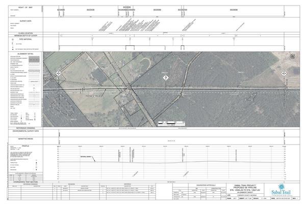
Sabal Trail
alignment map 1657-PL-DG-70197-241,
courtesy Lowndes Area Knowledge Exchange (LAKE).
 Watkins Road
has a stream crossing, labeled S1TRC567 on
Sabal Trail alignment map 1657-PL-DG-70197-240
and
S3TRC567 569 on the sign at the site.
Watkins Road
has a stream crossing, labeled S1TRC567 on
Sabal Trail alignment map 1657-PL-DG-70197-240
and
S3TRC567 569 on the sign at the site.
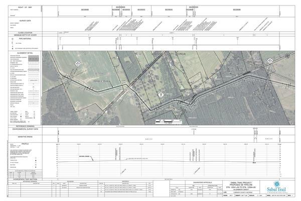
Sabal Trail alignment map 1657-PL-DG-70197-240,
courtesy Lowndes Area Knowledge Exchange (LAKE).
 Lowndes County recently paved
Phillips Road,
with curb and gutter through its tree canopy.
You wouldn't know there was a pipeline down there unless you looked at
the above alignment map, or you drove almost to the end of the road.
Lowndes County recently paved
Phillips Road,
with curb and gutter through its tree canopy.
You wouldn't know there was a pipeline down there unless you looked at
the above alignment map, or you drove almost to the end of the road.
For context, see Sabal Trail maps digitized.
For much more context, see http://www.wwals.net/issues/stt/.
You can join this fun and work by becoming a WWALS member today!
Follow
this link
for the google map, and it's also embedded below.
![[Sabal Trail road work signs, Rocky Ford Rd n. of Ousley Rd. 30.7185802, -83.3842823]](small/20161212_170510.jpg)
Sabal Trail road work signs, Rocky Ford Rd n. of Ousley Rd. 30.7185802, -83.3842823
![[Approaching Barrett Coody Rd. 30.7289378, -83.3840539]](small/20161212_170518.jpg)
Approaching Barrett Coody Rd. 30.7289378, -83.3840539
![[Sabal Trail visible past Barrett Coody Rd. 30.7292721, -83.3840801]](small/20161212_170520.jpg)
Sabal Trail visible past Barrett Coody Rd. 30.7292721, -83.3840801
![[Red pipe e. of Rocky Ford Road 30.7317922, -83.3837431]](small/20161212_170542.jpg)
Red pipe e. of Rocky Ford Road 30.7317922, -83.3837431
![[Blue pipe w. of Rocky Ford Road 30.7326762, -83.3835023]](small/20161212_170552.jpg)
Blue pipe w. of Rocky Ford Road 30.7326762, -83.3835023
![[Tires e. of Rocky Ford Road 170620-0 30.7327762, -83.3836051]](small/20161212_170620-0.jpg)
Tires e. of Rocky Ford Road 170620-0 30.7327762, -83.3836051
![[Old pipeline sign e. of Rocky Ford Road 170620 30.7327762, -83.3836051]](small/20161212_170620.jpg)
Old pipeline sign e. of Rocky Ford Road 170620 30.7327762, -83.3836051
![[Porta-potty and silt fence e. of Rocky Ford Road 30.7327762, -83.3836051]](small/20161212_170622.jpg)
Porta-potty and silt fence e. of Rocky Ford Road 30.7327762, -83.3836051
![[Power line caution sign e. of Rocky Ford Road 170631 30.7349013, -83.3838019]](small/20161212_170631.jpg)
Power line caution sign e. of Rocky Ford Road 170631 30.7349013, -83.3838019
![[Blue pipe s. of Watkins Rd. 30.7363883, -83.3856436]](small/20161212_171307.jpg)
Blue pipe s. of Watkins Rd. 30.7363883, -83.3856436
![[Closeup blue pipe s. of Watkins Rd. 30.7361111, -83.3855556]](small/20161212_171309.jpg)
Closeup blue pipe s. of Watkins Rd. 30.7361111, -83.3855556
![[Pipe along Watkins Rd. 30.7363509, -83.3879320]](small/20161212_171339.jpg)
Pipe along Watkins Rd. 30.7363509, -83.3879320
![[Movie: Along Watkins Road (1.1M) 30.7363509, -83.3879320]](small/20161212_171341.jpg)
Movie: Along Watkins Road (1.1M) 30.7363509, -83.3879320
![[Dirt berm s. of Watkins Road 30.7364100, -83.3887725]](small/20161212_171352.jpg)
Dirt berm s. of Watkins Road 30.7364100, -83.3887725
![[Turn along Watkins Road 30.7365738, -83.3889677]](small/20161212_171356.jpg)
Turn along Watkins Road 30.7365738, -83.3889677
![[Movie: Pipe propped up s. Watkins Rd. (105M) 30.7366166, -83.3893317]](small/20161212_171406.jpg)
Movie: Pipe propped up s. Watkins Rd. (105M) 30.7366166, -83.3893317
![[Phone line and silt fence n. Watkins Rd. 30.7360910, -83.3939848]](small/20161212_171503.jpg)
Phone line and silt fence n. Watkins Rd. 30.7360910, -83.3939848
![[Movie: Sabal Trail n. Watkins Rd. (25M) 30.7360978, -83.3939041]](small/20161212_171511.jpg)
Movie: Sabal Trail n. Watkins Rd. (25M) 30.7360978, -83.3939041
![[S1TRC5677 s. Watkins Rd. 30.7358994, -83.3943271]](small/20161212_171644.jpg)
S1TRC5677 s. Watkins Rd. 30.7358994, -83.3943271
![[e. on Watkins Rd. 30.7358994, -83.3943271]](small/20161212_171647.jpg)
e. on Watkins Rd. 30.7358994, -83.3943271
![[Waterbody Boundary, Watkins Rd. 30.7358994, -83.3943271]](small/20161212_171651.jpg)
Waterbody Boundary, Watkins Rd. 30.7358994, -83.3943271
![[Silt fence s. Watkins Rd. 30.7358994, -83.3943271]](small/20161212_171653.jpg)
Silt fence s. Watkins Rd. 30.7358994, -83.3943271
![[Waterbody Boundary S3TRC567 569 30.7358994, -83.3943271]](small/20161212_171708.jpg)
Waterbody Boundary S3TRC567 569 30.7358994, -83.3943271
![[No Refueling, Watkins Rd. 30.7358994, -83.3943271]](small/20161212_171715.jpg)
No Refueling, Watkins Rd. 30.7358994, -83.3943271
![[Tires and No Refueling, Watkins Road 30.7358994, -83.3943271]](small/20161212_171719.jpg)
Tires and No Refueling, Watkins Road 30.7358994, -83.3943271
![[Silt fence and berm s. of Watkins Rd. 30.7363201, -83.3891177]](small/20161212_171815.jpg)
Silt fence and berm s. of Watkins Rd. 30.7363201, -83.3891177
![[Watkins Rd. s. to Rocky Ford Road 30.7363255, -83.3891821]](small/20161212_171820.jpg)
Watkins Rd. s. to Rocky Ford Road 30.7363255, -83.3891821
![[Phillips Road @ Rocky Ford Road 30.7423975, -83.3824492]](small/20161212_172016.jpg)
Phillips Road @ Rocky Ford Road 30.7423975, -83.3824492
![[Movie: Canopy Phillips Rd curb, gutter, and Sabal Trail 172034 (181M) 30.7423975, -83.3824492]](small/20161212_172034.jpg)
Movie: Canopy Phillips Rd curb, gutter, and Sabal Trail 172034 (181M) 30.7423975, -83.3824492
![[Movie: Sabal Trail, s. of Phillips Road (78M) 30.7381849, -83.4006753]](small/20161212_172209.jpg)
Movie: Sabal Trail, s. of Phillips Road (78M) 30.7381849, -83.4006753
![[Movie: Sabal Trail, Phillips Rd. (34M) 30.737983, -83.399940]](small/20161212_172316.jpg)
Movie: Sabal Trail, Phillips Rd. (34M) 30.7379830, -83.3999400
![[Pipe heading north from Phllips Rd. 30.7387607, -83.3988377]](small/20161212_172436.jpg)
Pipe heading north from Phllips Rd. 30.7387607, -83.3988377
![[Sabal Trail n. Phillips Rd. 30.7387607, -83.3988377]](small/20161212_172438.jpg)
Sabal Trail n. Phillips Rd. 30.7387607, -83.3988377
![[e. on Phillips Rd. 30.7378439, -83.3999567]](small/20161212_172439.jpg)
e. on Phillips Rd. 30.7378439, -83.3999567
| 

![[Troy Access, Nankin Road 30.6655972, -83.4706892]](small/20161212_165148.jpg)
![[Ochlawilla Baptist Church 30.6655972, -83.4706892]](small/20161212_165152.jpg)
![[Troy Access Nankin Road closeup 30.6652778, -83.4708333]](small/20161212_165156.jpg)
![[Barrett Coody Rd. e. of Rocky Ford Rd. 30.730016, -83.383751]](small/20161212_170653.jpg)
![[Blue pipe s. Barrett Coody Rd. 30.7302313, -83.3837876]](small/20161212_170723.jpg)
![[Movie: s of Barrett Coody Rd. (23M) 30.7302313, -83.3837876]](small/20161212_170726.jpg)
![[w. on Barrett Coody Rd. 30.7316305, -83.3754294]](small/20161212_171007.jpg)
![[n. of Barrett Coody Rd. 30.7305477, -83.3802895]](small/20161212_171046.jpg)
![[Movie: from Barrett Coody R. to Rocky Ford Rd. (47M) 30.7305477, -83.3802895]](small/20161212_171048.jpg)
