
The Alapaha River is an intermittent river.
A river is a natural watercourse, usually freshwater, flowing towards an ocean, a lake, a sea, or another river. In some rare cases a river could flow into the ground and dry up completely at the end of its course, without reaching another body of water.
—River, on Wikipedia
The sinks or siphons and springs are some of the most interesting features of the Alapaha River Water Trail.
Sinks or Siphons
Chris Mericle says:
The Alapaha River undergoes a dramatic change about 3 miles
downstream of Sasser Landing and 1 mile upstream from Jennings Bluff
Launch.
 Through cavernous openings in the limestone the Alapaha
River departs the river bed into two sinks or siphons and travels
underground approximately 10 miles to the Alapaha Rise on the
Suwannee River. During low water levels all of the river is taken
into these siphons leaving the river bed downstream a sandy path,
good for hiking, with occasional pockets of water. During medium and
high water levels the sinks cannot take the entire volume of the
river allowing the excess water to flow to the Suwannee.
Through cavernous openings in the limestone the Alapaha
River departs the river bed into two sinks or siphons and travels
underground approximately 10 miles to the Alapaha Rise on the
Suwannee River. During low water levels all of the river is taken
into these siphons leaving the river bed downstream a sandy path,
good for hiking, with occasional pockets of water. During medium and
high water levels the sinks cannot take the entire volume of the
river allowing the excess water to flow to the Suwannee.
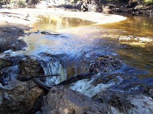
- The upstream sink is on the west bank of the river and is known by several names, The Alapaha River Sink, The Suck Hole and Devil’s Den (30.5854, -83.052728).
-
 The downstream sink (approx. ¼ mi
downstream) is known as the Dead River or The Siphon (30.57912,
-83.053276). The Dead River is also on the west bank and is a narrow
winding run almost whitewater in nature about 1/4mi long
dramatically ending with all the water in the run violently being
sucked underground.
The downstream sink (approx. ¼ mi
downstream) is known as the Dead River or The Siphon (30.57912,
-83.053276). The Dead River is also on the west bank and is a narrow
winding run almost whitewater in nature about 1/4mi long
dramatically ending with all the water in the run violently being
sucked underground.
Florida’s Fabulous Canoe and Kayak Trail Guide calls the Alapaha River potentially the most dangerous river in Florida. It goes on to say about the siphons:
“Are they Dangerous? You bet. Do not approach them; pass them by. No long monstrous arm will reach out, but exceptionally careless adventurers could be in danger…”
I personally would not pass them by. You will never see anything like these geological wonders anywhere. A paddler can put-out on the west bank and hike along the bank to carefully view this awesome site. Or for a nice hiking experience you can drive to the Jennings Bluff Launch, from the parking area hike the trail that leads upstream along the river. It is about a 45 minute walk to the Dead River.
Directions to the Jennings Bluff Launch: From Jennings, Hamilton County, FL, travel south on US 41 to NW 25 Lane; turn left; travel east to NW 82 Court and the entrance into the Suwannee River Water Management District’s Jennings Bluff tract. Follow the drive about a mile to the parking area.
According to Alan Cressler, whose picture is used below with permission:
At low water levels, all the water in the Alapaha River sinks into a cave system. The cave is developed in the Oligocene age Suwannee Limestone.
There is no dry passage. To the best of my knowledge, the water is not seen again until it reaches the Alapaha Rise Spring on the north side of the Suwannee River about twenty miles away. That spring is a large tannin spring.
Alapaha River Rise

30° 26′ 20.3" N 83° 05′ 22.4" W. About 600 feet north of the Suwannee River, near Gibson Park Ramp, the Alapaha River comes out of a spring. According to Springs Fever: A Field & Recreation Guide to 500 Florida Springs, 2nd Edition, by Joe Follman and Richard Buchanan,
From Madison, take U.S. 90 east 2-3 miles until the fork with State Road 6. Take SR6 east, across the Withlacoochie[sic] River, and proceed about 12 miles to County Road 751. Turn right and drive about four miles to Suwannee River. Take boat ramp at Hutch Gibson Park (on the NW side of the river), and canoe upriver about ¼ mile. A few hundred feet past the CR751 bridge, you will see water rushing out with great force on the left — it is the mouth of the spring run.
For maps, latitude/longitude data, driving directions, satellite imagery, and topographic representations as well as weather conditions at this spring, go to Greg Johnson’s informative “Florida Springs Database” web site at the following address: http://www.ThisWaytothe.Net/springs/floridasprings.htm#Florida
The Alapaha Sink and Rise are what Samuel Taylor Coleridge was describing in his famous poem, Kubla Khan:
Where Alph, the sacred river, ran
Through caverns measureless to man
Down to a sunless sea.
So twice five miles of fertile ground
With walls and towers were girdled round;
And there were gardens bright with sinuous rills,
Where blossomed many an incense-bearing tree;
And here were forests ancient as the hills,
Enfolding sunny spots of greenery.But oh! that deep romantic chasm which slanted
Down the green hill athwart a cedarn cover!
A savage place! as holy and enchanted
As e’er beneath a waning moon was haunted
By woman wailing for her demon-lover!
And from this chasm, with ceaseless turmoil seething,
As if this earth in fast thick pants were breathing,
A mighty fountain momently was forced:
Amid whose swift half-intermitted burst
Huge fragments vaulted like rebounding hail,
Or chaffy grain beneath the thresher’s flail:
And mid these dancing rocks at once and ever
It flung up momently the sacred river.
Five miles meandering with a mazy motion
Through wood and dale the sacred river ran,
Then reached the caverns measureless to man,
And sank in tumult to a lifeless ocean; ….
Coleridge read about the Alapaha River in the Travels of William Bartram, describing his trip of 1773-1777, with allusions to previous trip. The online Bartram Trail write about the effect of William Bartram’s Travels on the English Romantics:
Bartram was describing not merely the New World, but one of its most exotic regions, the subtropical forests, rivers, and savannas that were so unlike the tame English countryside
It’s not totally clear that Bartram ever actually crossed the Alapaha River, and the other candidate for the Alph is the Santa Fe River in Florida, another tributary of the Suwannee River. But Alph sure looks like Alapaha with a few letters missing….
 Both Alapaha and Santa Fe go underground where they encounter the
Ocala Platform,
an area of higher limestone in west central Florida.
Their downstream river, the Suwannee, flows through the Ocala Platform without going underground.
Both Alapaha and Santa Fe go underground where they encounter the
Ocala Platform,
an area of higher limestone in west central Florida.
Their downstream river, the Suwannee, flows through the Ocala Platform without going underground.
Here is a related passage from Bartram’s Travels, page 175:
BEHOLD now at still evening, the sun yet streaking the embroidered savannas, armies of fish pursuing their pilgrimage to the grand pellucid fountain, and when here arrived, all quiet and peaceable, encircle the little cerulean hemisphere, descend into the dark caverns of the earth; where probably they are separated from each other, by innumerable paths, or secret rocky avenues; and after encountering various obstacles, and beholding new and unthought of scenes of pleasure and disgust, after many days absence from the surface of the world, emerge again from the dreary vaults, and appear exulting in gladness, and sporting in the transparent waters of some far distant lake.
Pingback: Alapaha Sink: WWALS Outing 2PM 26 Oct 2014 - WWALS Watershed Coalition
Pingback: Sasser landing to Jennings Bluff, WWALS Outing 2015-06-14 - WWALS Watershed Coalition
Pingback: Alapaha River Rise, Suwannee River, and Sabal Trail Pipeline, WWALS Outing 2015-08-15 - WWALS Watershed Coalition
Pingback: Exploring the Alapaha River - WWALS Watershed Coalition
Pingback: Lanier Park to CSX RR track Hotchkiss Road, WWALS outing 2015-07-11 - WWALS Watershed Coalition
Pingback: Update: Sabal Trail Pipeline, Alapaha, Suwannee, and Withlacoochee Rivers, WWALS Outing 2015-08-15 - WWALS Watershed Coalition
Pingback: Alapaha Tour for FL Paddling Coordinator, Sasser Landing to Jennings Bluff 2015-09-27 | WWALS Watershed Coalition
Pingback: Streamer on the Suwannee, Alapaha, and Withlacoochee Rivers | WWALS Watershed Coalition