
Trail Description: Table of Contents
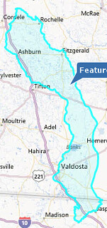
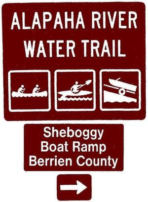 The Alapaha River Water Trail connects about 128 miles of the 202-mile Alapaha River from Sheboggy Boat Ramp (US 82) in Berrien County, Georgia to the Suwannee River in Hamilton County, Florida.
Plus 11 of the 14 miles of the Alapahoochee River, which flows from near Statenville, Georgia to join the Alapaha in Hamilton County.
The Alapaha River Water Trail connects about 128 miles of the 202-mile Alapaha River from Sheboggy Boat Ramp (US 82) in Berrien County, Georgia to the Suwannee River in Hamilton County, Florida.
Plus 11 of the 14 miles of the Alapahoochee River, which flows from near Statenville, Georgia to join the Alapaha in Hamilton County.
See interactive Map and access points.
Suggest additions or corrections.
Help fund ARWT signs and brochures and water quality testing.
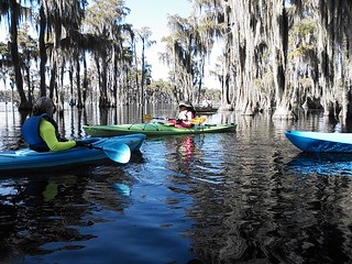
The Alapaha and Alapahoochee’s tea-colored tannin waters class them as blackwater rivers, flowing below bald cypress, longleaf, slash, and loblolly pines, and majestic oaks, with great blue herons, snapping turtles, alligators, and fish.
You can paddle with us on our many outings, including the entire ARWT on the 2018 Alapaha Quest!
![]() Please become a WWALS member to support our water trails and our advocacy. You may also want to join the
WWALS Water Trails Committee.
Please become a WWALS member to support our water trails and our advocacy. You may also want to join the
WWALS Water Trails Committee.
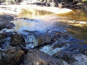
Mostly flat, the Alapaha River also contains rapids, many springs, and the Alapaha Sink. Its distributary the one-mile Dead River ends in the Dead River Sink, where it goes underground much of the year, until the water comes back up 19 miles and three days later in the Alapaha River Rise on the Suwannee River. Covering its entire flood plain in the rainy season, and less than a foot deep in spots during dry spells, the Alapaha River is a treasure and a challenge. The Alapaha River Water Trail also includes the Alapahoochee River, as well as many lakes, ponds, and swamps that are boatable year round.
Table of Contents:
Trail Description,
Wild and Scenic,
Many Years of Harmony,
Etiquette,
Lakes, Ponds, and Swamps,
River Basin,
Location,
Distance,
Access Points,
Classification of Trail,
Water Levels,
Float Plan,
Outfitters,
Overnight Trip Option,
Website,
Map and Spreadsheet,
Sponsors and Partners,
Contact Information,
Nearest Population Center,
Media,
Implementation,
GRN grant documents,
Context.
Wild and Scenic
The Alapaha River was described as “unspoiled, wild, and scenic” in the 1979 Soil Survey of Lowndes County. It is described as “Jungle-like in its remoteness and luxurious with exotic vegetation, the dark reddish-brown waters of the Alapaha wind through a swampy wonderland teeming with wildlife” by Brown’s Guide to Georgia, and rates an “A+” for scenery by Canoeing & Kayaking Georgia.
Many Years of Harmony
 The Alapaha River has been used for years by canoeists and boaters in harmony with local landowners.
In Brown’s Guide Suzanne Welander refers to the Alapaha Canoe Trail, as she did in
A Canoeing and Kayaking Guide to Georgia, by Suzanne Welander, Bob Sehlinger and Don Otey, 2004 (see also her more recent Canoeing & Kayaking Georgia), and as mentioned in Southern Georgia Canoeing by Bob Sehlinger and Don Otey, 1980.
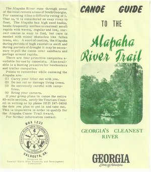
The Alapaha River may still be, as described in 1970s brochures, “Georgia’s Cleanest River”.
This time, WWALS is acknowledging more long-used access points upstream and downstream into Florida, where the Suwannee River Water Management District (SRWMD) has long included the Alapaha River in Florida as part of the
Suwannee River Wilderness Trail.
The Alapaha River has been used for years by canoeists and boaters in harmony with local landowners.
In Brown’s Guide Suzanne Welander refers to the Alapaha Canoe Trail, as she did in
A Canoeing and Kayaking Guide to Georgia, by Suzanne Welander, Bob Sehlinger and Don Otey, 2004 (see also her more recent Canoeing & Kayaking Georgia), and as mentioned in Southern Georgia Canoeing by Bob Sehlinger and Don Otey, 1980.
The Alapaha River may still be, as described in 1970s brochures, “Georgia’s Cleanest River”.
This time, WWALS is acknowledging more long-used access points upstream and downstream into Florida, where the Suwannee River Water Management District (SRWMD) has long included the Alapaha River in Florida as part of the
Suwannee River Wilderness Trail.
Etiquette
And of course we promote Water Trail safety and etiquette.
Lakes, Ponds, and Swamps
 Plus the Alapaha River Watershed contains lakes, ponds, and swamps such as Banks Lake in Lanier County, Grand Bay in Lowndes County, and the Carolina Bays in Atkinson County, renowned for their fishing, alligators, turtles, birds, cypresses, and pines, and streams including the Alapahoochee River. Existing hiking and biking trails can be linked to the Water Trail to encourage more multi-purpose participation.
The Alapaha River is not readily boatable upstream in Tift, Turner, Crisp, and Dooly Counties, nor on the Willacoochee River in Irwin, Ben Hill, and Wilcox Counties.
River Basin

Suwannee River Basin
9,950 square miles, 5,720 in Georgia and 4,230 in Florida.
Alapaha River watershed
1,840 square miles, 1,726 in Georgia and 114 in Florida.
Distance
202 miles: Alapaha River from its source in Dooly County, Georgia, to its confluence with the Suwannee River in Hamilton County, Florida.
129 miles: Alapaha River Water Trail from US 82 to the Suwannee River, plus many lakes, ponds, and swamps to the side.
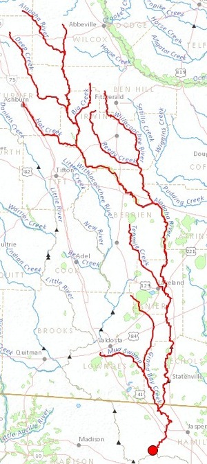
![[ARWT in Alapaha River watershed]](https://www.wwals.net/pictures/2021-02-10--arwt-maps/2021-02-10--arwt-map.jpg)
Access Points
 A dozen public access points, and another boat ramp being built.
See
the ARWT Access web page.
A dozen public access points, and another boat ramp being built.
See
the ARWT Access web page.
Classification of Trail
Class 1 Rapids with mostly flatwater, on an undammed blackwater river with no industrial development and no large point sources of pollution.
Water Levels
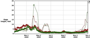 Alapaha River water levels fluctuate, and the river may be canoeable or floatable only a few weeks or months per year.
All the record high levels have been in January through April,
but the Alapaha River can be high in almost any other month.
Paddle times may vary widely depending on ability of the paddler
and the level of the water; going may be especially slow at low water levels, due to deadfalls in the river.
Alapaha River water levels fluctuate, and the river may be canoeable or floatable only a few weeks or months per year.
All the record high levels have been in January through April,
but the Alapaha River can be high in almost any other month.
Paddle times may vary widely depending on ability of the paddler
and the level of the water; going may be especially slow at low water levels, due to deadfalls in the river.
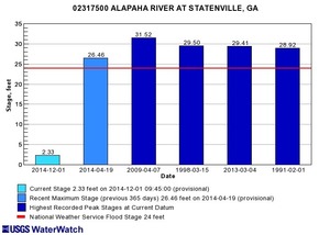 For example in the middle parts of the river, when the Statenville gauge shows more than 6 feet, it is too high to
paddle; less than
2 feet is too low.
For example in the middle parts of the river, when the Statenville gauge shows more than 6 feet, it is too high to
paddle; less than
2 feet is too low.
WWALS includes high and low water indicators in the printed materials for different sections of the river, and online along with the current water levels online, using the gauges at Jennings, FL, at Statenville, GA, at US 82 near Alapaha, and at GA 125/32 near Irwinville.
Meanwhile, there are deep areas (lakes) on the river that are boatable most of the year, and lakes in the Alapaha River watershed that are boatable year-round.
Float Plan
WWALS provides a float plan form for boaters to fill out and file, so friends and, if unfortunately necessary, emergency responders can find them.
Outfitters
Many outfitters: see separate web page.
Overnight Trip Option
Yes. No reservation, permit or fee required in Georgia for rough camping on islands.
Camping on SRWMD lands in Florida is free with a permit, obtainable by calling SRWMD at 386.362.1001.
 Website
wwals.net/maps/alapaha-water-trail/
Map and Spreadsheet
Follow this link for an interactive ARWT map, along with indexes by access points, categories, and all points, plus a link to the spreadsheet from which all these are made.
Printed and going to outfitters, motels, businesses, Chambers, near you: Map, Brochure, and Card all in one. Two editions of 10,000 copies each are all gone. Using a generous grant from the Georgia Department of Natural Resources, we have printed a third edition of these brochures.
![[Alapaha River Water Trail]](https://www.wwals.net/pictures/2019-10-17--wt-brochure-proofs/2019-09-04--ARWT-front.jpg)
![[ARWT Where to put in]](https://www.wwals.net/pictures/2019-10-17--wt-brochure-proofs/2019-10-17--ARWT-mapside-proof-0001.jpg)
Sponsoring Organizations and Partners:
WWALS Watershed Coalition through a $500 grant from Georgia River Network, requesting sponsorship from Tift, Atkinson, Berrien, Lanier, Lowndes, and Echols Counties, Georgia, and Hamilton County, Florida, cities near the river, businesses, and other organizations.
- 2013-11-05: Lowndes County, GA, voters approved the Naylor Boat Ramp and its park in the Special Local Option Sales Tax (SPLOST) referendum.
 2014-10-26:
$250 and resolution of support from Hamilton County, Florida Tourist Development Council
2014-10-26:
$250 and resolution of support from Hamilton County, Florida Tourist Development Council
- 2014-11-05: Letter of support from Valdosta-Lowndes County Chamber of Commerce
- 2014-11-05: $500 check from Valdosta-Lowndes County Tourism Authority
- 2014-11-18: Resolution of support from the Hamilton County, Florida Board of Commissioners
- 2015-01-21: Letter of support from the Valdosta-Lowndes Development Authority
- 2016-09-14: Letter from Berrien County authorizing WWALS to put signs on county land at three landings in Berrien County.
- 2018-01-08: Resolution of support from the Lanier County, Georgia Board of Commissioners
- 2018-01-18: Resolution of support from the Atkinson County, Georgia Board of Commissioners
- 2018-03-06: Berrien County Commission vote to rename two landings to become Sheboggy Boat Ramp and Berrien Beach Boat Ramp.
- 2018-04-05: Resolution of support from Valdosta Mayor and City Council.
- 2018-04-07: “Alapaha River Beauty should Not be Hidden,” unsolicited video testimonial by Lanier County Emergency Management.
- 2020-06-13: Lowndes County has built Naylor Boat Ramp at US 84, and handed over the surrounding park to Valdosta-Lowndes Parks and Recreation Authority (VLPRA), including the popular beach between the ramp and the US 84 bridge. We planted road signs for Naylor Boat Ramp years ago using funds from WWALS memberships: you can still help pay for those. We put at-water signs there in June 2020, using the GA-DNR grant (see below).
- 2020: A generous grant from the Georgia Department of Natural Resources (GA-DNR) enabled WWALS to design, print, and plant at-water signs for the ARWT, and to publish 10,000 z-fold brochures which we are distributing for free through welcome centers and rest stops on I-75 and I-95 in Georgia and Florida, as well as through county and city governments, parks, outings, and festivals. Your donations to WWALS help defray the cash match for that grant.
- 2021-06-30: The Mayor of Valdosta wrote a letter supporting redesignation of the Withlacoochee and Alapaha Rivers from Fishing to Recreational.
- 2021-08-11: The Georgia Environmental Protection Division (GA-EPD) did redesignate parts of the Withlacoochee and Alapaha Rivers.
-
2021-08-31: The Valdosta-Lowndes County Parks and Recreation Authority (VLPRA) updated Master Plan includes as goals:
- 6.1 Continue to work with the county and WWALS to construct a network of launches, ramps, camp sites, and river camps, similar to the amenities along the Suwannee River Wilderness Trail (SRWT) in north Florida (where possible).
- 6.2 Incorporate WWALS recommendations for improvements (for water quality, health and safety, and river access) into to a phased, 12-year River Access Improvement Plan, consistent with the SPLOST funding cycles.
Contact Information
John S. Quarterman, Suwannee Riverkeeper, WWALS Watershed Coalition, wwalswatershed@gmail.com
Nearest Population Center
Valdosta 55,000 population and Lake Park 734 (Lowndes County 113,000), Tifton 16,000 (Tift County 40,000), Alapaha 658 and Nashville 4,903 (Berrien County 19,000), Willacoochee 1,391 (Atkinson County 8,290), Lakeland 3,398 (Lanier County 10,408), Statenville (Echols County 4,000), and Jennings 833 and Jasper 4,221 (Hamilton County, Florida 14,000).
See also WWALS Cities and Counties.
Media
- 2015-03-23: Suwannee Democrat, 2 Hamilton County businesses donate prizes for logo contest
- 2015-03-20: Jasper News, Two Hamilton County businesses donate prizes for logo contest
- 2015-03-18: Valdosta CEO, South Georgia Talent Won the Alapaha River Water Trail Logo Contest
- 2015-03-13: Tifton Gazette: Prizes to High School Logo Contest Winners Saturday at Alapaha River Water Trail Conference
- 2015-03-11: Valdosta CEO: Prizes to High School Logo Contest Winners at Alapaha River Water Trail Conference
 2014-10-27: WWALS Ambassador Dave Hetzel explains the Alapaha River Water Trail on YouTube.
-
 2014-08-19:
WWALS President John S. Quarterman discusses the Alapaha Water Trail as a quality-of-life economic development asset at the Valdosta-Lowndes County Economic Development Authority.
2014-08-19:
WWALS President John S. Quarterman discusses the Alapaha Water Trail as a quality-of-life economic development asset at the Valdosta-Lowndes County Economic Development Authority.
- 2014-07-27: WWALS receives Alapaha Water Trali grant, Tifton Gazette
- 2014-07-21: WWALS gets grant from river network, Valdosta Daily Times
See also News.
Implementation:
- See draft Map.
- See access points and spreadsheet.
- See affected organizations.
- See timeline for further events, both past and future.
- 2014-08-05: facebook group established.
-
 2014-08-05: First in-person committee meeting, at El Cazador Mexican Restaurant in Valdosta. Attendees:
Chris Graham (chair), John S. Quarterman, Dave Hetzel, April Huntley, Brett Huntley, Chris Mericle, Deanna Mericle, Gretchen Quarterman, and Bret Wagenhorst (by phone).
2014-08-05: First in-person committee meeting, at El Cazador Mexican Restaurant in Valdosta. Attendees:
Chris Graham (chair), John S. Quarterman, Dave Hetzel, April Huntley, Brett Huntley, Chris Mericle, Deanna Mericle, Gretchen Quarterman, and Bret Wagenhorst (by phone).
- 2014-07-21: Press Release
- 2014-07-10: est. email list wwals-art@googlegroups.com.
- 2014-07-09: WWALS Alapaha Water Trail Committee established by WWALS Board at its regular meeting.
- 2014-06-25: Blueway Trails in South Georgia? by Christopher Lee Graham, Lanier County Advocate
- 2013-02-04: Water trails for economic benefit —Bret Wagenhorst
- See also Alapaha River
GRN grant documents:
-
 Gwyneth Moody, Community Programs Coordinator and Water Trail contact for Georgia River Network.
- 2015-05-15: Final Grant Report to GRN
- 2015-01-15: Mid-Year Progress Report
- 2014-06-19: WWALS-GRN Contract for Alapaha Water Trail Seed Grant
- 2014-06-19: WWALS Seed Grant Acceptance Cover Letter from GRN
- 2014-05-23: WWALS Water Trails Seed Grant Application to GRN
- 2014-04: GRN/Turner Foundation Mini Grant Program 2014
Context
-
 Georgia Water Trails Website at Georgia River Network
- A good example: Etowah Water Trail
- Another example: Ocmulgee River Trail
- Example Resolutions of Support
- Georgia Recreational Trails Program
Pingback: Alapaha River @ US 84: endpoint of Sunday's WWALS Outing 24 August 2014 - WWALS Watershed Coalition
Pingback: Counties and Cities in WWALS Watersheds - WWALS Watershed Coalition
Pingback: Alapaha River Cleanup at US 82, 27 September 2014 - WWALS Watershed Coalition
Pingback: Okefenokee Outing @ Fargo, GA 2014-11-22 - WWALS Watershed Coalition
Pingback: Video: The Alapaha River Water Trail -Dave Hetzel - WWALS Watershed Coalition
Pingback: Video: The Alapaha River Water Trail –Dave Hetzel - Our Santa Fe River, Inc., a 501 (c) (3) Non-Profit Florida Corporation
Pingback: Alapaha River water levels - WWALS Watershed Coalition
Pingback: Alapaha River Water Levels - Our Santa Fe River, Inc., a 501 (c) (3) Non-Profit Florida Corporation
Pingback: WWALS at Alapaha Celebration Days - WWALS Watershed Coalition
Pingback: Thank you for your efforts on behalf of the Alapaha River Water Trail -Valdosta-Lowndes County Chamber of Commerce - WWALS Watershed Coalition
Pingback: Canoeing Guide to the Alapaha River c. 1979 - WWALS Watershed Coalition
Pingback: Cleanup on Alapaha River near Jasper, FL: WWALS Outing 2014-12-20 - WWALS Watershed Coalition
Pingback: Little Alapaha River - WWALS Watershed Coalition
Pingback: 1970s Canoe Trail FAQ - WWALS Watershed Coalition
Pingback: WWALS Board meeting 2015-01-14 - WWALS Watershed Coalition
Pingback: WWALS logo contest for Alapaha River Water Trail - WWALS Watershed Coalition
Pingback: Water Trail Etiquette - WWALS Watershed Coalition
Pingback: Quality of life and the Alapaha River Water Trail - WWALS Watershed Coalition
Pingback: Videos: VLDA appointment, jail, taxes, water @ LCC 2015-01-12 | On the LAKE front
Pingback: Videos: Packets, paving, safety, trash, education, appointment, jail, taxes, water @ LCC 2015-01-13 | On the LAKE front
Pingback: Statenville to Sasser Landing on the Alapaha River, WWALS Outing, 2015-02-15 - WWALS Watershed Coalition
Pingback: WWALS Goals for 2014 - WWALS Watershed Coalition
Pingback: Naylor Park and Boat Ramp aerial plan map - WWALS Watershed Coalition
Pingback: Easy Outing on the Alapaha River at GA 135, 2015-03-14 - WWALS Watershed Coalition
Pingback: Prizes to high school logo contest winners Saturday at Alapaha River Water Trail Conference - WWALS Watershed Coalition
Pingback: South Georgia talent won the Alapaha River Water Trail Logo Contest - WWALS Watershed Coalition
Pingback: Green corridors are good for people, business, plants, and animals | On the LAKE front
Pingback: Rowetown Church to GA 135: WWALS April outing 2015-04-18 - WWALS Watershed Coalition
Pingback: WWALS Board Agenda 2015-04-08 - WWALS Watershed Coalition
Pingback: Update on Rowetown Church to GA 135: WWALS outing 2015-04-18 - WWALS Watershed Coalition
Pingback: Sasser landing to Jennings Bluff, WWALS Outing 2015-06-14 - WWALS Watershed Coalition
Pingback: Pictures: Rowetown Church to GA 135 -Bret Wagenhorst - WWALS Watershed Coalition
Pingback: Alapaha River Rise, Suwannee River, and Sabal Trail Pipeline, WWALS Outing 2015-08-15 - WWALS Watershed Coalition
Pingback: WWALS at Earth Day by S.A.V.E. at Drexel Park near VSU today - WWALS Watershed Coalition
Pingback: WWALS on environmental issues panel in Valdosta at LCDP 2015-06-01 - WWALS Watershed Coalition
Pingback: Boating with Gwyneth on Lake Lewis and the Alapaha River 2015-05-25 - WWALS Watershed Coalition
Pingback: Brochures for Alapaha River Water Trail - WWALS Watershed Coalition
Pingback: This sister earth now cries out to us -Pope Francis - WWALS Watershed Coalition
Pingback: Burnt Church in Lakeland to Hotchkiss in Stockton -Chris Graham 2015-06-21 - WWALS Watershed Coalition
Pingback: Mayday to Statenville paddle trip on the Alapaha river. - WWALS Watershed Coalition
Pingback: Lanier Park to CSX RR track Hotchkiss Road, WWALS outing 2015-07-11 - WWALS Watershed Coalition
Pingback: Florida lists WWALS for Alapaha River Water Trail - WWALS Watershed Coalition
Pingback: WWALS Water Trails at Southern Georgia Regional Commission Council 2015-07-23 - WWALS Watershed Coalition
Pingback: Update: Sabal Trail Pipeline, Alapaha, Suwannee, and Withlacoochee Rivers, WWALS Outing 2015-08-15 - WWALS Watershed Coalition
Pingback: Banks Lake Full Moon Paddle: bring bon-bons! 2015-08-29 - WWALS Watershed Coalition
Pingback: Pictures: Lakeland to Hotchkiss Road, WWALS Outing –Gretchen Quarterman 2015-07-11 | WWALS Watershed Coalition
Pingback: WWALS @ Alapaha Station Celebration today 2015-11-14 | WWALS Watershed Coalition
Pingback: Grand Bay Hike: WWALS Outing 2015-12-12 | WWALS Watershed Coalition
Pingback: Alapaha River Boat Ramp land purchase approved by Lowndes County Commission 2015-12-08 | WWALS Watershed Coalition
Pingback: WWALS at Grand Bay –Pictures by Gretchen Quarterman 2015-12-12 | WWALS Watershed Coalition
Pingback: End of the Year Membership Donations to WWALS | WWALS Watershed Coalition
Pingback: Satilla River Water Trail in Brunswick News | WWALS Watershed Coalition
Pingback: WWALS outings on Chris Beckham drive-time radio WVGA 105.9 FM 7:30 AM 2016-01-15 | WWALS Watershed Coalition
Pingback: Stranded campers rescued from Alapaha River above GA 135 2016-01-16 | WWALS Watershed Coalition
Pingback: WWALS Outings and Events late 2015 – early 2016 | WWALS Watershed Coalition
Pingback: Hotchkiss Road to Mayday, Alapaha River 2016-04-23 | WWALS Watershed Coalition
Pingback: WWALS at Rhythm & Ribs, Tifton, GA 2016-03-05 | WWALS Watershed Coalition
Pingback: Map of American Rivers by Nelson Minar | WWALS Watershed Coalition
Pingback: WWALS Outings, Rivers, and Pipeline on Chris Beckham drive-time radio WVGA 105.9 FM 8:00 7:30 AM 2016-09-02 | WWALS Watershed Coalition
Pingback: Hike to Dead River Sink from Alapaha River 2016-11-06 | WWALS Watershed Coalition
Pingback: WWALS Adopt-A-Stream Cleanup at Berrien Beach Landing (GA 168) –Gretchen Quarterman 2016-09-10 | WWALS Watershed Coalition
Pingback: Naylor Boat Ramp bid twice; probably instead in-house by Lowndes County | WWALS Watershed Coalition
Pingback: WWALS at Alapaha Station Celebration 2016-11-12 | WWALS Watershed Coalition
Pingback: Aerials: Dry Alapaha River and the Alapaha Rise 2016-11-23 | WWALS Watershed Coalition
Pingback: GA 168 (Berrien Beach) to GA 122 (Lakeland) Alapaha River Outing 2017-02-11 | WWALS Watershed Coalition (Suwannee RIVERKEEPER)
Pingback: WWALS receives grant for water conservation outreach to farmers and community | WWALS Watershed Coalition (Suwannee RIVERKEEPER®)
Pingback: GA HR 281 Water Trails resolution | WWALS Watershed Coalition (Suwannee RIVERKEEPER®)
Pingback: Improved Sheboggy Ramp, Alapaha River @ US 82 | WWALS Watershed Coalition (Suwannee RIVERKEEPER®)
Pingback: Banks Lake Full Moon Paddle 2017-07-08 | WWALS Watershed Coalition (Suwannee RIVERKEEPER®)
Pingback: WMA signs in Lanier County, Alapaha River | WWALS Watershed Coalition (Suwannee RIVERKEEPER®)
Pingback: Alapaha River, Hotchkiss Road to US 84 2017-04-02 | WWALS Watershed Coalition (Suwannee RIVERKEEPER®)
Pingback: Banks Lake Full Strawberry Moon Paddle, 2021-06-24 | WWALS Watershed Coalition (Suwannee RIVERKEEPER®)
Pingback: Juneteenth at Reed Bingham State Park, Little River, Reed Bingham State Park East Boat Ramp, 2021-06-19 | WWALS Watershed Coalition (Suwannee RIVERKEEPER®)
Pingback: Cleanup Paffords Landing, Alapaha River 2021-07-24 | WWALS Watershed Coalition (Suwannee RIVERKEEPER®)
Pingback: Clean Rivers Again 2021-06-10 | WWALS Watershed Coalition (Suwannee RIVERKEEPER®)
Pingback: Upgrade Suwannee River Basin rivers to Recreational –WWALS to GA-EPD 2021-06-30 | WWALS Watershed Coalition (WWALS) is Suwannee RIVERKEEPER®
Pingback: WWALS Watershed Coalition thanks Atkinson Commission for support –WFXL TV 2021-07-09 | WWALS Watershed Coalition (WWALS) is Suwannee RIVERKEEPER®
Pingback: If We Cared About The Environment Like We Care About Sports –Buzzfeed - Our Santa Fe River, Inc. (OSFR)
Pingback: WWALS calls in the Marines to clean up Pafford’s Landing 2021-07-24 | WWALS Watershed Coalition (WWALS) is Suwannee RIVERKEEPER®
Pingback: Not-so-dry Alapaha River to Suwannee River –Bobby McKenzie 2021-05-07 | WWALS Watershed Coalition (WWALS) is Suwannee RIVERKEEPER®
Pingback: Last stretch of Alapaha River, US 41 to Gibson Park 2022-02-05 | WWALS Watershed Coalition (WWALS) is Suwannee RIVERKEEPER®
Pingback: Pictures: Banks Lake Full Cold Moon paddle 2021-12-18 | WWALS Watershed Coalition (WWALS) is Suwannee RIVERKEEPER®
Pingback: Pictures: Alapahoochee River, GA 135 to Sullivan Launch 2021-06-05 | WWALS Watershed Coalition (WWALS) is Suwannee RIVERKEEPER®
Pingback: Jennings Bridge, Alapaha River 2022-01-05 | WWALS Watershed Coalition (WWALS) is Suwannee RIVERKEEPER®
Pingback: Pictures: Last stretch, Alapaha River 2022-02-05 | WWALS Watershed Coalition (WWALS) is Suwannee RIVERKEEPER®
Pingback: Earth Day Rivers Alive Trash Clean Up, Pafford’s Landing, Alapaha River 2022-04-16 | WWALS Watershed Coalition (WWALS) is Suwannee RIVERKEEPER®
Pingback: Pictures: Alapaha River Outing, Hotchkiss Road to US 84 2014-08-24 | WWALS Watershed Coalition (WWALS) is Suwannee RIVERKEEPER®
Pingback: Statenville to Sasser Landing, Alapaha River, plus Turket Creek Waterfall 2022-07-09 | WWALS Watershed Coalition (WWALS) is Suwannee RIVERKEEPER®
Pingback: Ideas for short paddles | WWALS Watershed Coalition (WWALS) is Suwannee RIVERKEEPER®
Pingback: Paddle Sasser Landing to Jennings Bluff, Hike to Dead River Sink, Alapaha River, 2022-10-01 | WWALS Watershed Coalition (WWALS) is Suwannee RIVERKEEPER®
Pingback: Sunday: Paddle Sasser Landing to Jennings Bluff, Hike to Dead River Sink, Alapaha River, 2022-10-02 | WWALS Watershed Coalition (WWALS) is Suwannee RIVERKEEPER®
Pingback: Pictures: Berrien Beach Cleanup, Alapaha River 2022-09-24 | WWALS Watershed Coalition (WWALS) is Suwannee RIVERKEEPER®
Pingback: Pictures: Alapaha Station Celebration 2019-11-09 | WWALS Watershed Coalition (WWALS) is Suwannee RIVERKEEPER®
Pingback: WWALS at Alapaha Station Celebration 2022-11-12 | WWALS Watershed Coalition (WWALS) is Suwannee RIVERKEEPER®
Pingback: Alapaha River Cleanup, Sasser Landing and Statenville Boat Ramp, 2023-01-07 | WWALS Watershed Coalition (WWALS) is Suwannee RIVERKEEPER®
Pingback: River Low, Action, and Flood Stages 2023-02-16 | WWALS Watershed Coalition (WWALS) is Suwannee RIVERKEEPER®
Pingback: Pictures: Jennings Bluff Florida State Geological Site with Dead River Sink 2023-03-17 | WWALS Watershed Coalition (WWALS) is Suwannee RIVERKEEPER®
Pingback: Dock work at Gibson Park Ramp 2023-05-25 | WWALS Watershed Coalition (WWALS) is Suwannee RIVERKEEPER®
Pingback: Jennings Bluff Tract State Geological Site, Cedar Keys Formation, and Madison Blue Spring –FGS News and Research 2023-05-01 | WWALS Watershed Coalition (WWALS) is Suwannee RIVERKEEPER®
Pingback: Water Trail Brochures available: Alapaha, Withlacoochee, and Little Rivers | WWALS Watershed Coalition (WWALS) is Suwannee RIVERKEEPER®
Pingback: Work in progress at Lakeland Boat Ramp 2023-06-20 | WWALS Watershed Coalition (WWALS) is Suwannee RIVERKEEPER®
Pingback: Pictures: WWALS at Alapaha Station Celebration 2022-11-12 | WWALS Watershed Coalition (WWALS) is Suwannee RIVERKEEPER®
Pingback: WWALS at Alapaha Station Celebration 2023-11-11 | WWALS Watershed Coalition (WWALS) is Suwannee RIVERKEEPER®
Pingback: Rivers Alive Trash Pick Up, Alapaha River, Mayday Landing, 2025-09-20 | WWALS Watershed Coalition (WWALS) is Suwannee RIVERKEEPER®
Pingback: Pictures: Georgia Rivers Alive Trash Pick Up, Alapaha River, Mayday Landing, 2025-09-20 | WWALS Watershed Coalition (WWALS) is Suwannee RIVERKEEPER®
Pingback: WWALS Booth at Alapaha Station Celebration 2025-11-08 | WWALS Watershed Coalition (WWALS) is Suwannee RIVERKEEPER®
Pingback: Pictures: WWALS Booth at Alapaha Station Celebration 2025-11-08 | WWALS Watershed Coalition (WWALS) is Suwannee RIVERKEEPER®