The WWALS map of the Suwannee River Water Trail runs from the Okefenokee Swamp in Georgia to the Gulf of Mexico, including the Santa Fe, Ichetucknee, and New Rivers.
See WWALS SRWT interactive map and access points.
![[SRWT Logo Crop]](https://www.wwals.net/pictures/2017-11-13--suwannee-watersheds/small/SRWT-bass-logo-crop.jpg)
For the Okefenokee Swamp, our main references are here: Okefenokee Wilderness Area Canoe Trails.
Florida’s Suwannee River Wilderness Trail from White Springs to the Gulf existed before WWALS, and we constantly draw on its materials, in communication with its organizers, as well as many other sources, including direct research, upstream and downstream all the way to the Gulf. We have paper maps of the Wilderness Trail at our booth at festivals and events. Or you can get them at SRWMD HQ in Live Oak. Or try calling their contact number: 800-868-9914.
Where the Wilderness Trail maps specify a milepoint for a landing on the Suwannee or Santa Fe Rivers, the WWALS SRWT maps usually use that mile, since those miles have been published for many years. Other points on the SRWT maps are interpolated according to USGS river tracks and other information.
See also the FDEP Paddling Guides of Florida Designated Paddling Trails for the Santa Fe River, the Ichetucknee River, the Withlacoochee River North. These guides oddly have miles from upstream to downstream. They’re also only even miles, so not precise enough to factor into the WWALS maps.
For the Estuary, see the Big Bend Saltwater Paddling Trail, which is part of the Florida Circumnavitational Saltwater Paddling Trail (CT). In the specific maps and text for Segment 6: Big Bend, see:
- Map 6: Horseshoe Beach to Shired Island County Campground
- Map 7: Anderson Landing
- Map 8: Shell Mound Campground and Cedar Key City Beach Park
See also FLORIDA CIRCUMNAVIGATIONAL SALTWATER PADDLING TRAIL MAP SET and Florida Circumnavigational Saltwater Paddling Trail Guide (Text Only): Seventh Edition Paperback – July 3, 2019.
Many of the items from these CT maps and references are in the WWALS SRWT Access page under Florida Circumnavigational Saltwater Paddling Trail, with CT miles and distances between them. More CT items are in the WWALS SRWT Categories and Points web pages. The WWALS SRWT map also includes other Estuary access points that are not in the CT maps.
Also for the Estuary, see Dixie County’s Paddling Maps and trails overviews by Friends of the Lower Suwannee & Cedar Keys National Wildlife Refuges.
Suggest additions or corrections.
![[Context, Suwannee River Water Trail]](https://www.wwals.net/pictures/2023-10-26--lafayette-county-suwannee-river-wilderness-trail/big/2023-11-01--srwt-context.jpg)
Context, Suwannee River Water Trail
See also the WWALS map of all landings in the Suwannee River Basin.
- The five River Camps offer air-conditioned bathrooms with hot and cold running water, five screened sleeping platforms with electricity, primitive camping, and fire pits. Reservations for river camps are made through the Suwannee River Wilderness Trail at 800.868.9914. Reservations for cabins are made through Reserve America (800.326.3521 or 866 I CAMP FL).
- Resolution in Support of National Water Trail Designation of The Suwannee River in Madison County 2016-10-12
-
Resolution in Support of National Water Trail Designation of The Suwannee River in Suwannee County, Suwannee BOCC, 2016-12-06

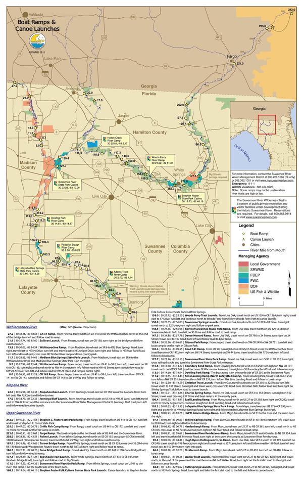
SRWMD poster of boat ramps and canoe launches on the Suwannee River Wilderness Trail. - The SRWMD Boating and Canoeing web page has important river level information.
- Thanks to Florida State Parks for an excellent overview, including links to a paddling guide, and a two-page map. Plus a float plan you should file. And a list of outfitters.
- A very unusual and popular feature of the SRWT is the five River Camps, with hot and cold running water, showers, bathrooms, and elevated sleeping platforms with screens.
- The SRWT paddling guide includes very helpful Safety and etiquette tips.
- Thanks to Suwannee River Water Management District (SRWMD) for numerous maps of numerous types in numerous formats.
- Blog post 10 April 2011, Kayak the Suwannee River – Fargo Ga to the Fla Gulf (days 1-2) .
- Paddle Florida, Upper Suwannee River.
- Suwannee Adventures, Paddle Guide for Lower Suwannee River.
- U.S. Fish and Wildlife Service Lower Suwannee National Wildlife Refuge Canoe/Kayak Trail.


