
One of only six second magnitude springs in the state of Georgia, McIntyre Spring is about half a mile upstream from where the Withlacoochee River crosses into Florida for the first time. Here it is seen with kayaks, in Google Earth Pro, for May 17, 2025, looking south and downstream.
![[McIntyre Spring with boats, Withlacoochee River --Google Earth Pro, May 27, 2017]](https://www.wwals.net/pictures/2017-05-27--mcintyre-spring-withlacoochee-river-google-earth-pro/fbmany.jpg)
McIntyre Spring with boats, Withlacoochee River –Google Earth Pro, May 27, 2017
Previously I speculated that the kayaks in this Google Earth Pro map were from the WWALS paddle of October 14, 2017. Since then, Google Earth Pro has supplied a more specific date of May 27, 2017 for this map, so the dates do not seem to match.
Brooks County claims the entire river to its left (usually east) bank, so McIntyre Spring is in that county. It is also on private land, inaccessible by road without permission.
To see McIntyre Spring in the river, the water level must be low. Preferably no higher than about 1.75 feet (85.26 NAVD) on the US 84 Quitman gage, and about 6.57 (53.08 NAVD) on the the Pinetta gage.
Those were the readings on July 9, 2016.
![[WWALS banner at McIntyre Spring 30.6416416, -83.3660354]](https://www.wwals.net/pictures/2016-07-09--nankin-ga-fl-line/KIMG5948.jpg)
WWALS banner at McIntyre Spring 30.6416416, -83.3660354
McIntyre Spring is 4 and a half miles downstream from Clyattville-Nankin Boat Ramp and four and a third miles upstream from State Line Boat Ramp, aka Mozell Spells, below which the river goes permanently into Florida.
Beware that there are many shoals between McIntyre Spring and State Line Boat Ramp. State Line Shoals, which is actually in Florida before the river goes back north briefly into Georgia, is sometimes Whitewater Class II.
McIntyre Spring has 4610 feet of explored cave. Don’t try that unless you are an experienced cave diver like Guy Bryant, who mapped that cave system, and who took video of a dive there on November 18, 2017.
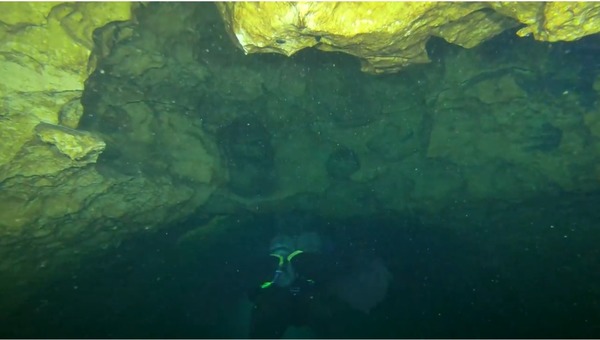
Photo: Guy Bryant
Here’s a more current map with imagery apparently from March 28, 2024. Note that this map has north at the top.
![[Map: Mcintyre Spring Withlacoochee River --WLRWT 2025-10-18]](https://www.wwals.net/pictures/2017-05-27--mcintyre-spring-withlacoochee-river-google-earth-pro/2025-10-18--map-mcintyre-spring-withlacoochee-river-wlrwt.jpg)
Map: Mcintyre Spring Withlacoochee River
in the WWALS
map of the Withlacoochee and Little River Water Trail (WLRWT)
-jsq, John S. Quarterman, Suwannee RIVERKEEPER®
You can help with clean, swimmable, fishable, drinkable, water in the 10,000-square-mile Suwannee River Basin in Florida and Georgia by becoming a WWALS member today!
https://wwals.net/donations/
Short Link:
Pingback: Cleanup and outing, Nankin, Mcintyre and Arnold Springs, Mozell Spells, Withlacoochee River 2017-10-14 | WWALS Watershed Coalition (WWALS) is Suwannee RIVERKEEPER®