
Please vote for clean water!
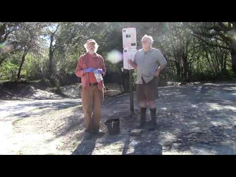
Suwannee Riverkeeper John S. Quarterman and WWALS Science Committee Chair Dr. Tom Potter took a moment from water quality sampling at Knights Ferry Boat Ramp on the Withlacoochee River to make these videos to ask everyone to vote for clean water.
Vote for people who will fully fund the Florida Department of Environmental Protection and the Georgia Environmental Protection Division so they can do some river sampling themselves, and watch over not only Valdosta, but also Quitman, Adel, Tifton, Rochelle, and Ashburn, all of which have spilled sewage into the Suwannee River Basin this year.
Vote for people who will protect the Okefenokee Swamp from strip mining and other threats.
We could also mention Nestlé, phosphate mines, coal ash, and many other issues.
We’ve never met anyone who wants to drink dirty water. So please vote for clean water! Continue reading
![[Chart, State Line, Boomerang, FL-6]](/pictures/2020-10-22--wq/many.jpg)
![[KF, Nankin, State Line, Results, Swim Guide, plate]](https://www.wwals.net/pictures/2020-10-15--wq/many.jpg)
![[Charts and Map: Ashburn spills to GA-FL line]](https://www.wwals.net/pictures/2020-09-27--ashburn-spills/many.jpg)
![[Green Swim Guide and test results]](https://www.wwals.net/pictures/2020-10-08--wq/many.jpg)
![[Withlacoochee, Quitman spill, Running Springs, Suwannee]](https://www.wwals.net/pictures/2020-04-24--quitman-spill-wq/many.jpg)
![[Lifted, Green on Swim Guide, Sources]](https://www.wwals.net/pictures/2020-10-05--wq/many.jpg)
![[Water Quality Testing]](https://www.wwals.net/pictures/2020-08-18--suwrk-steve-nichols-radio/5testing.jpg)
![[Flyer: Cleanup on three rivers, many creeks]](https://www.wwals.net/pictures/2020-10-10--tri-river-cleanup/trioflyer.jpg)
![[Little, New, Withlacoochee, Summary, Alapaha River]](https://www.wwals.net/pictures/2020-09-30--sewage-spills-suwannee-river-basin/many.jpg)
![[Chart, State Line, Swim Guide, Advisory]](https://www.wwals.net/pictures/2020-10-02--wq/many.jpg)