
Update 2016-10-10: Going beyond the ones named in FERC’s commence order, this blog post includes maps for ALL RIVER CROSSINGS IN ALL THREE STATES!
Update 2016-10-10: All 527 of Sabal Trail’s April 2016 alignment maps are now available in small, big, huge, and PDF formats, courtesy of Lowndes Area Knowledge Exchange (LAKE): follow this link to the LAKE website.
Nevermind that
historic 128 to 34 Georgia House vote against river-drilling easements.
 The Georgia Attorney General’s office declined to defend lawsuits in
county Superior Courts (including Lowndes County, GA), and judges gave Sabal Trail the easements.
Then the U.S. Army Corps of Engineers issued its permit.
So Thursday John Peconom of FERC told Sabal Trail to start drilling under
Georgia’s Chattahoochee,
Flint, Ochlockonee, and
Withlacoochee Rivers,
as well as
Hannahatchee Creek.
They avoided Okapilco Creek by
planning on plowing through
Hog Creek just upstream in Colquitt County.
The Georgia Attorney General’s office declined to defend lawsuits in
county Superior Courts (including Lowndes County, GA), and judges gave Sabal Trail the easements.
Then the U.S. Army Corps of Engineers issued its permit.
So Thursday John Peconom of FERC told Sabal Trail to start drilling under
Georgia’s Chattahoochee,
Flint, Ochlockonee, and
Withlacoochee Rivers,
as well as
Hannahatchee Creek.
They avoided Okapilco Creek by
planning on plowing through
Hog Creek just upstream in Colquitt County.

Only Georgia rivers are included in FERC’s particular commence order; not Alabama’s Tallapoosa River, Oaktasasi Creek, or Hillabee Creek, and not Florida’s Suwannee River, Santa Fe River, Withlacoochee South River, or Shingle Creek. But don’t be surprised when Mr. Peconom, doling out go-aheads bit by bit, gets around to targetting those streams as well. Profit for a pipeline company from Houston, Texas is, after all, more important to FERC than our rivers, aquifer, drinking water, or property rights.
 Yes, there are things you can do, listed at the end of
Federal permits inflame opposition to Sabal Trail fracked methane pipeline boondoggle WWALS PR 2016-08-16
Yes, there are things you can do, listed at the end of
Federal permits inflame opposition to Sabal Trail fracked methane pipeline boondoggle WWALS PR 2016-08-16
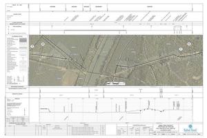
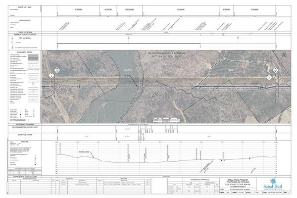
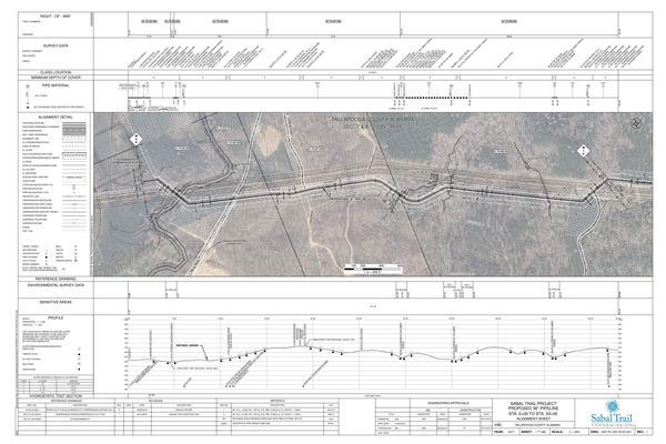
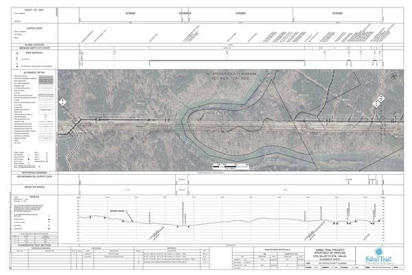
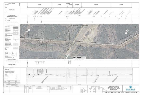
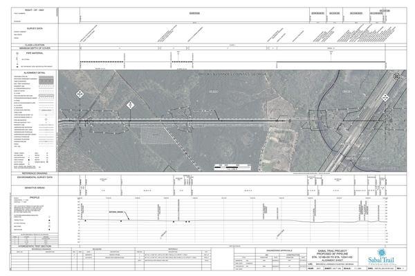
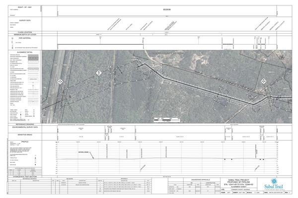
People wanted to know exactly where are these river crossings.
See the maps shown here (click on any one of them for a larger image),
pulled from Sabal Trail’s alignment sheets of 7 April 2016,
filed with FERC as
 Accession Number 20160407-5081,
“Sabal Trail Transmission, LLC submits its Implementation
Plan—Supplemental Information for the Sabal Trail Project
under CP15-17.”
Accession Number 20160407-5081,
“Sabal Trail Transmission, LLC submits its Implementation
Plan—Supplemental Information for the Sabal Trail Project
under CP15-17.”
John Peconom’s letter refers to those April alignment sheets,
and his letter was filed with FERC 25 August 2016 as
Accession Number 20160825-3045,
 “Letter order granting Sabal Trail Transmission, LLC’s 8/19/16
request to commence construction of certain Phase 1 facilities for
the Sabal Trail Project under CP15-17.”
“Letter order granting Sabal Trail Transmission, LLC’s 8/19/16
request to commence construction of certain Phase 1 facilities for
the Sabal Trail Project under CP15-17.”
The full text of his letter is below, followed by the maps; click on any one of them to get a bigger one.
-jsq
You can join this fun and work by becoming a WWALS member today!
2
FEDERAL ENERGY REGULATORY COMMISSION
WASHINGTON, D.C. 20426
OFFICE OF ENERGY PROJECTS
In Reply Refer To:
OEP/DG2E/Gas Branch 3
Sabal Trail Transmission, LLC
Sabal Trail Project
Docket No. CP15-17-000
§375.308(x)
August 25, 2016
Ms. Lisa A. Connolly
General Manager, Rates and Certificates
Sabal Trail Transmission, LLC
5400 Westheimer Court, Suite 6N61
Houston, TX 77056
Re: Authorization to Commence Construction of Previously Excluded Phase 1 Facilities
Ms. Connolly:
In accordance with the Federal Energy Regulatory Commission’s (Commission) February 2, 2016 Order Issuing Certificates and Approving Abandonment (Order), I grant Sabal Trail Transmission, LLC’s (Sabal Trail) August 19, 2016 request to commence construction of certain Phase 1 facilities as identified in the following table1.
Start Station No.
End Station No.
Project Component Description
4552+54
4570+54
Chattahoochee River Crossing
4818+72
4832+56
Hannahatchee Creek Crossing
8588+62
8625+42
Flint River Crossing
10513+57
10531+57
Ochlockonee River Crossings (2)
12222+21
12261+06
Withlacoochee River Crossing
This authorization is based on my review of Sabal Trail’s Request for Notice to Proceed; its compliance with the environmental conditions of the Commission’s Order as described in its Implementation Plan filed on March 11, 2016, and supplemented on April 7, 2016, July 21, 2016, August 11, 2016, and August 15, 2016; and its documentation of the necessary federal authorizations applicable to the requested activities.
I remind you that Sabal Trail must comply with all applicable terms and conditions of the above referenced Order. If you have any questions regarding this authorization, please contact me at (202) 502-6352.
Sincerely,
John V. Peconom
Environmental Project Manager
cc: Public File, Docket No. CP15-17-000
1 The station numbers correspond with the construction alignment sheets (Revision 1) filed with the Commission on April 7, 2016.
Spread 1: Alabama

Spread 2: Stewart to Colquitt Co., GA

Spread 3: Mitchell to Lowndes Co., GA

Spread 4: Suwannee, Gilchrist, Alachua, Levy, Marion Co., FL

Spread 5: Gilchrist to Lake & Citrus Co., FL

Spread 6: Sumter to Osceola Co., FL

Tallapoosa River HDD, Tallapoosa Co., AL
Oaktasas Creek, Alexander City Compressor Station, Tallapoosa Co., AL
Hillabee Creek HDD, Tallapoosa Co., AL
Hillabee Creek @ AL 22, Tallapoosa Co., AL
Chattahoochee River HDD, Russell Co. AL, Stewart Co., GA

Hannahatchee Creek HDD, KMI Pipeline, Chattahoochee Valley Trail, Stewart Co., GA

Norfolk Southern RR, Dougherty Co., GA

West Oarkridge Dr., Dougherty Co., GA

KMI Pipeline, Dixie Pipeline, Kreg Ave.,, Flint River HDD Begins, Dougherty Co., GA

Flint River HDD, Dougherty Co., GA

Ochlockonee River HDD, Colquitt Co., GA

Ice House America, Colquitt Co., GA

Hog Creek @ Crosby Road, Colquitt Co., GA

Withlacoochee River HDD, Brooks Co. & Lowndes Co., GA
U384 & Withlacoochee River HDD, KMI Pipeline, Lowndes Co, GA
Suwannee River HDD, Hamilton Co. & Suwannee Co., FL

Suwannee River HDD, Suwannee Co., FL

Hildreth Compressor Station, Suwannee Co., FL

FGT Suwannee M&R Station, Suwannee Co., FL

Santa Fe River HDD, Suwannee Co. & Gilchrist Co., FL

Santa Fe River HDD end, Gilchrist Co., FL

Withlacoochee South River HDD, Marion & Citrus Co., FL

Dunnellon Compressor Station, Marion Co., FL

Shingle Creek HDD, Hunters Creek Pipeline, Osceola Co., FL

Dyer Blvd. HDD, Hunters Creek Pipeline, Osceola Co., FL

Thacker Ave., Hunters Creek Pipeline, Osceola Co., FL

Short Link:
Pingback: WWALS Outings, Rivers, and Pipeline on Chris Beckham drive-time radio WVGA 105.9 FM 8:00 AM 2016-09-02 | WWALS Watershed Coalition