
Update 2016-03-03: Please see Streamer on the Suwannee, Withlacoochee, and Alapaha.
 Here in our WWALS watersheds
in south central Georgia,
instead of a single big river like the Flint or Altamaha, our many
small blackwater streams meander through cypress swamps and remnants
of longleaf pine forests. Tannin from oak roots produces the tea color
that is one of many attractive features of our streams.
Here in our WWALS watersheds
in south central Georgia,
instead of a single big river like the Flint or Altamaha, our many
small blackwater streams meander through cypress swamps and remnants
of longleaf pine forests. Tannin from oak roots produces the tea color
that is one of many attractive features of our streams.
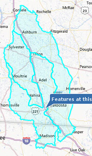
Maybe you, like me, have trouble keeping track of the watersheds of the Willacoochee, Withlacoochee, Alapaha and Little River Systems. U.S. EPA has much useful information about every U.S. watershed. On the right is a map I got EPA’s My WATERS Mapper to make by clicking on a point near Valdosta (a point just north of Tifton also works) that was close to all three WWALS watersheds known to that Graphical Information System (GIS):
- Alapaha Watershed — 03110202
- Withlacoochee Watershed — 03110203
- Little Watershed — 03110204