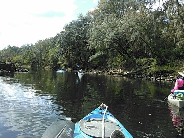
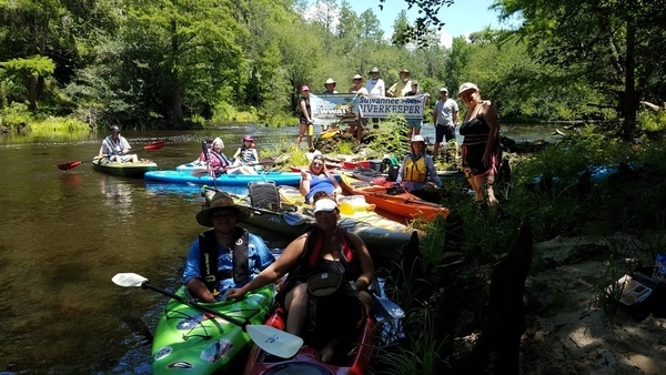
Author Archives: jsq

Here

Lots more pictures now posted of this sunny Suwannee River outing past springs and sand like snow, plus Hands Across the Sand.

 -jsq, John S. Quarterman, Suwannee RIVERKEEPER®

You can join this fun and work by becoming a WWALS member today!

Wade Spring, 7 miles east of Quitman, GA, May 2017

Local cave diver Aaron Sirmons took these pictures and videos of the formerly famous Wade Springs of Brooks County, Georgia, between Blue Springs Road and the railroad, west of the Withlacoochee River. He has a letter of permission from the landowner.

Concentric circles, late March 2017

Concentric circles, late March 2017

Almost dry, May 2017

Continue reading

Revised Hydrogeologic Framework of the Floridan Aquifer System 2016-03

Updated 2026-04-23: Improved figure implementation, added springs map, and for desalination see also https://wwals.net/issues/wfnf.

Salt water intrusion inland is worse than you think, including the “Apalachicola salinity feature” up to the GA-FL line and east through Lowndes County, with a special additional brackish Valdosta feature. Central north Florida is an island of fresh groundwater surrounded by entire saline Florida coast around from Alabama plus across to Brunswick, GA, then again from Savannah up past Charleston. South of Lakeland, FL the map is all red for saline.

[Salt water intrusion inland is worse than you think, Apalachicola salinity feature, and all the coasts of Florida]
Salt water intrusion inland is worse than you think, Apalachicola salinity feature, and all the coasts of Florida

Apparently using the data preliminarily mapped earlier in the Florida Well Salinity Study, geologists from three states connected the dots in Revised Hydrogeologic Framework of the Floridan Aquifer System in Florida and Parts of Georgia, Alabama, and South Carolina, By Continue reading

Aerials: Woods Ferry Tract to Suwannee Springs 2016-11-23

These aerial photographs by Beth Gammie cover the route of the Saturady 20 May 2017 WWALS Outing down the Suwannee River from Woods Ferry Tract Launch to Suwannee Springs. She took them for WWALS 23 November 2016, on a Southwings flight piloted by Roy Zimmer. They’re all looking from Hamilton County south (or west) across the Suwannee River into Suwannee County.

Woods Ferry Tract Launch

Woods Ferry Tract Launch

I have pulled out a few detail shots, of Woods Ferry Tract Launch and of Suwannee Springs.

Suwannee Springs bathhouse

Continue reading

Woods Ferry to Suwannee Springs, Outing and Hands Across the Sands, Suwannee River 2017-05-20

Update 2023-04-13: Pictures.

Due to low water, we’re moving the May 20th outing downstream! With lunch, swim stops, and bon-bons, of course. Bring bug spray and the usual personal flotation device, boat paddles, food, drinking water, warm clothes, and first aid kit. If you don’t have a boat, there are many outfitters, or let us know and many of us have spare boats.

Two outfitters advise there should be enough water on this route to avoid much boat dragging. There is a slight 30% possibility of afternoon thunder showers. Same date, same time, same river: just a bit downstream.

When: 9AM Saturday May 20, 2017, meet to shuttle
10AM: Start paddling
12PM noon: Stop for Hands Across the Sand
   “Say NO to dirty fuels and YES to clean energy”
2-3PM: Finish some time around then

Put In: Mile 158.0, Woods Ferry Tract Launch, in Suwannee County, Florida

GPS of Entrance: to Woods Ferry Tract 30.343508, -82.855187

Paddle Distance: 8.0 river miles

Paddle Duration: 4 hours

Event: facebook, meetup

Shuttle route

Directions to Put In: From Live Oak, travel north on Continue reading