
Looks like we may finally see Action stage tomorrow on the Withlacoochee River above Valdosta @ Skipper Bridge Road. This is upstream from Valdosta’s Withlacoochee Wastewater Treatment Plant, so it’s a good thing that didn’t spill during Irma. The Alapaha River at Statenville peaked Tuesday and probably would be a fine ride (what shoals?) today. The New and The Santa Fe Rivers are still flooding, and that’s still raising the Suwannee River all the way to the Gulf, and there’s minor flooding all the way up at Fargo, so another surge of high levels may follow on the Suwannee. The I-75 Santa Fe River bridge never did close.

2017-09-17 Withlacoochee River above Valdosta @ Skipper Bridge Road
The Suwannee River at White Springs peaked Tuesday. At Branford it’s about to peak on this seventh day after Hurricane Irma, while it’s in Action stage at Wilcox and Fowlers Bluf and expected to continue up all this week.

2017-09-17 Suwannee River at Fowlers Bluff
The Santa Fe River peaked Friday at Fort White, and still is in Moderate flood. Current road closures can be found on FL511.

2017-09-17 Santa Fe River near Fort White
The New River near Lake Butler after its record-breaking levels is still in minor flood a week out. You can tell the Union County, Florida Comissioners Monday that it’s not a good place for a phosphate mine.

2017-09-17 New River near Lake Butler
Below are images for each gage in the Suwannee River Basin that has projections, plus a few. Since Irma came from the south, for each gage from downstream to upstream, here are:
- a static image from Sunday, 10 September 2017 as Irma was arriving,
- a static image from Thursday, 14 September 2017, after Irma, but with some gages still going up while others go down, and
- a static image from Sunday, 17 September 2017, with the Withlacoochee and Suwannee still rising, and
- a live image of current conditions, which will increasingly diverge from Thursday’s image.
Click on any image for a larger version.
Suwannee River
Suwannee River Water Management District (SRWMD) has a frequently-updated table of levels for all these and the other gages on these rivers.
National Weather Service has a table with links to all its gages on the Suwannnee and its tributaries the Withlacoochee and Little Rivers.
Suwannee River at Fowlers Bluff
This one touched the Action stage, and now looks like it’s finally going to go halfway up to the Minor flood stage.

2017-09-10 Suwannee River at Fowlers Bluff

2017-09-14 Suwannee River at Fowlers Bluff

2017-09-17 Suwannee River at Fowlers Bluff

Live Suwannee River at Fowlers Bluff
Suwannee River at Wilcox @ US 19
Well, I missed this one. Looks like it might peak in Minor flood by this Friday, September 12, 2017.
So there is no static image from Sunday.
Why is it called Wilcox and not Fanning Springs, anyway?
2017-09-10 Suwannee River at Wilcox @ US 19

2017-09-14 Suwannee River at Wilcox @ US 19
Thanks to Trip Lancaster who took a screenshot.

2017-09-17 Suwannee River at Wilcox @ US 19

Live Suwannee River at Wilcox @ US 19
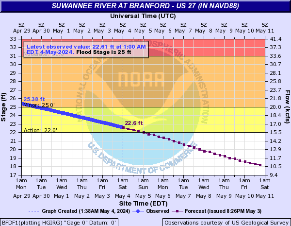
Suwannee River at Branford @ US 27
The projection was about 16.5 feet and it was about 15.69 on Monday the 14th: pretty close. But now it’s up to 20.46 feet and maybe finally peaking.

2017-09-10 Suwannee River at Branford @ US 27

2017-09-14 Suwannee River at Branford @ US 27

2017-09-17 Suwannee River at Branford @ US 27
Live Suwannee River at Branford @ US 27
Suwannee River near Suwannee Springs
Was projected to hit Minor flood about now, but hasn’t even reached Action stage. Looks like it peaked at 58.56 feet Thursday, well below Action stage at 61 feet.

2017-09-10 Suwannee River near Suwannee Springs

2017-09-14 Suwannee River near Suwannee Springs

2017-09-17 Suwannee River near Suwannee Springs

Live Suwannee River near Suwannee Springs
Suwannee River at White Springs
Went up to Minor flood faster than projected, peaked at 76.49 feet Tuesday morning, and is down to 72.6 feet Sunday Sept. 17th. You could paddle over Big Shoals with no rapids, but be sure to have search and rescue ready at the speed the water is going.

2017-09-10 Suwannee River at White Springs

2017-09-14 Suwannee River at White Springs

2017-09-17 Suwannee River at White Springs

Live Suwannee River at White Springs
Withlacoochee River
All the Withlacoochee and Little River gages are shown live on the Withlacoochee and Little River Water Trail (WLRWT) water levels page.
National Weather Service has a table with links to all its gages on the Suwannnee and its tributaries the Withlacoochee and Little Rivers.
Withlacoochee River near Pinetta @ CR 150
Was projected to hit Action stage at 59 feet about now, but was only 54.64 feet Thursday the 14th. Still rising at 55.15 feet today, Sunday the 17th.

2017-09-10 Withlacoochee River near Pinetta @ CR 150

2017-09-14 Withlacoochee River near Pinetta @ CR 150

2017-09-17 Withlacoochee River near Pinetta @ CR 150

Live Withlacoochee River near Pinetta @ CR 150
Withlacoochee River near Quitman @ US 84
Was projected to be about 97 feet by Thursday, just below Action stage and rising, but was only 88.61. Still rising at 92.41 feet today, Sunday the 17th.

2017-09-10 Withlacoochee River near Quitman @ US 84

2017-09-14 Withlacoochee River near Quitman @ US 84

2017-09-17 Withlacoochee River near Quitman @ US 84

Live Withlacoochee River near Quitman @ US 84
Withlacoochee River above Valdosta @ Skipper Bridge Road
Was projected to be in Minor flood at about 137 feet by Thursday the 14th, but was well below Action stage at 127.32. What’s with the strange jumping up and down? Log jams? It’s still rising at 130.1 feet today, Sunday the 17th, and may finally break Action stage at 131 feet.

2017-09-10 Withlacoochee River above Valdosta @ Skipper Bridge Road

2017-09-14 Withlacoochee River above Valdosta @ Skipper Bridge Road

2017-09-17 Withlacoochee River above Valdosta @ Skipper Bridge Road

Live Withlacoochee River above Valdosta @ Skipper Bridge Road
Alapaha River
All the Alapaha River gages are shown live on the Alapaha River Water Trail (ARWT) water levels page.
National Weather Service has a table with links to live gages for the Alapaha River.
Alapaha River at Statenville @ US 84
Was supposed to peak above Moderate flood at 100 feet by now, but peaked just below 84 feet Tuesday, well below Action stage of 90 feet, and was down to about 83 feet Thursday. Is 82.59 feet today, Sunday the 17th. Probably good paddling about now.

2017-09-10 Alapaha River at Statenville @ US 84

2017-09-14 Alapaha River at Statenville @ US 84

2017-09-17 Alapaha River at Statenville @ US 84

Live Alapaha River at Statenville @ US 84
Santa Fe River
National Weather Service has a table with links to its gages on the Santa Fe River and its tributary the New River.
Santa Fe River near Hildreth
Was supposed to be about 12.5 feet and rising by Thursday. Instead it was 16.33 feet near Action stage of 18 feet, expected to burst Minor flood of 20 feet on Friday and peak just below Moderate flood of 24 feet on Monday. Actually it’s peaking near 21.19 feet today, Sunday Sep 17th, expected to drop out of flood Tuesday and out of Action Thursday.

2017-09-10 Santa Fe River near Hildreth

2017-09-14 Santa Fe River near Hildreth

2017-09-17 Santa Fe River near Hildreth

Live Santa Fe River near Hildreth
Santa Fe River at Three Rivers Estates
Was expected to be about 20 feet Monday, peaking around Moderate flood at 21 feet Thursday. Actually was 18.22 feet Thursday, still in Minor flood, expected to peak at 25.2 feet in Major flood on Friday. It peaked Saturday at 24.55 feet in Major flood. Sunday Sept. 17th it’s 24.28 feet, expected do drop out of Moderate Wednesday but to still be in Minor flood Friday.

2017-09-10 Santa Fe River at Three Rivers Estates

2017-09-14 Santa Fe River at Three Rivers Estates

2017-09-17 Santa Fe River at Three Rivers Estates

Live Santa Fe River at Three Rivers Estates
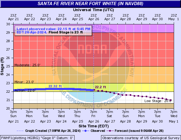
Santa Fe River near Fort White
Was expected to be 28 feet Thursday, peaking just below 29 feet Major flood. Actually it was 32.59 feet, expected to peak above 36 feet on Friday. Peaked at 34.46 feet on Friday, just below the record of 35.4 feet. Sunday Sept. 17th it’s down to 32.82 feet, expected to fall out of Major flood Wednesday but still to be in Minor flood Friday and presumably Satuday.

2017-09-10 Santa Fe River near Fort White

2017-09-14 Santa Fe River near Fort White

2017-09-17 Santa Fe River near Fort White
Live Santa Fe River near Fort White
New River
National Weather Service has a table with links to its gages on the Santa Fe River and its tributary the New River.
The tributary of the Santa Fe River between Union and Bradford Counties, Florida, not the tributary of the Withlacoochee River between Cook and Berrien Counties, Georgia (that Georgia New River has no gages).
New River near Lake Butler
This one in Union County didn’t need a projection to show water already rising, at 90 feet Sunday afternoon, in Action stage. It peaked Tuesday way into Major flood at 98.55, above the previous record of 98.2 feet. Thursday it was about 95 feet, still above Major flood level of 94 feet. Sunday Sept 17th down to 91.87 feet, still in Minor flood.

2017-09-10 New River near Lake Butler

2017-09-14 New River near Lake Butler

2017-09-17 New River near Lake Butler

Live New River near Lake Butler
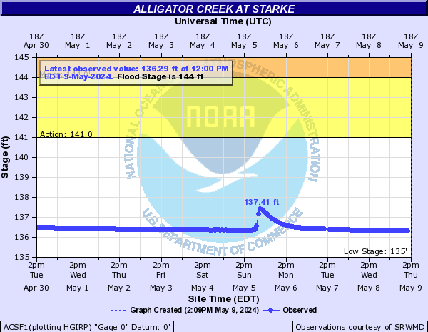
Alligator Creek at Starke
This one in Bradford County was already way into Major flood Sunday at 146.1 feet, above the previous record of 144.8 feet. It kept going up to 147.98 Monday. Then there was some weird discontinuity, after which it continued dropping, to just below Action stage of 137 feet on Thursday. Sunday Sept. 17th it’s out of action stage and almost out of water at 135 feet.

2017-09-10 Alligator Creek at Starke

2017-09-14 Alligator Creek at Starke

2017-09-17 Alligator Creek at Starke
Live Alligator Creek at Starke
water.weather.gov
These images and maps come from the National Weather Service Advanced Hydrologic Prediction Service.
Gage Map
Here are all these gages and the rest for all these rivers on a map. For Sunday, like for Friday, the gage map shows New River and the Santa Fe River in flood. Plus the flooding is moving down the Suwannee River, with more coming way up at Fargo.
Click through to the live map.

2017-09-10 Gage Map
I didn’t take a static image for Thursday.
So there’s no image for that day.
2017-09-14 Gage Map

2017-09-15 Gage Map

2017-09-17 Gage Map
The live map is JavaScript, so there’s no way to embed it here. Instead, follow this link.
Boating will be quite fast on some rivers this week, but probably you want to stay off the Santa Fe and New Rivers.
-jsq, John S. Quarterman, Suwannee RIVERKEEPER®
You can join this fun and work by becoming a WWALS member today!
Short Link:
Pingback: River Gage Projections after Hurricane Irma 2017-09-14 | WWALS Watershed Coalition (Suwannee RIVERKEEPER®)