
 What’s going on at the end of Sabal Trail’s Citrus County Line
at Duke’s new natural gas plant in Crystal River, Florida?
What’s going on at the end of Sabal Trail’s Citrus County Line
at Duke’s new natural gas plant in Crystal River, Florida?
The End of Line is the square in the upper left of the picture. But what’s all that equipment just east across the access road at 14001 West Power Line Street, Crystal River, FL, 28.963298, -82.667413? According to the Citrus County Property Appraiser, that other property is one small corner of a huge tract owned by HCR LIMESTONE INC, ATTN HOLCIM TAX DEPARTMENT, 201 JONES RD, WALTHAM MA 02451.
Meanwhile, there’s no activity at the official location of Strom Inc.’s Crystal River LNG export operation, at 6700 N Tallahassee Rd, Crystal River, FL 34428. Strom’s 2014-10-21 LNG export approval from the U.S. DoE Office of Fossil Energy (FE) says:
“According to Strom, the Project will be constructed on a property site approximately 15 acres in size. Strom states that it is engaging in a purchase agreement to acquire the property, and possibly to acquire neighboring properties.”
The 1600 N. Tallahassee Road location is about 15 acres, but so is that plot just across from the Citrus County End of Line, which could be considered “neighboring”.
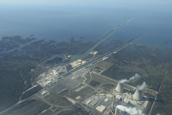
Also, until I saw the aerial below across Duke’s plants down the two canals to the Gulf, I had not realized how convenient that would be for an LNG export operation like Strom.
Below are some aerial pictures taken by Mark Skogman on a Southwings flight piloted by Roy Zimmer of Southwings for WWALS. Also on the flight and sending back other pictures were navigator Andrea Rea and Jim Tatum. And there’s a Google map showing the locations.
-jsq, John S. Quarterman, Suwannee RIVERKEEPER®
You can join this fun and work by becoming a WWALS member today!
Pictures
US-19, W Power Line St, Crystal River, FL, 28.9595700, -82.6302000

Strom Inc. site
All the photographers just missed getting a picture of the Strom, Inc. site (it happens).
Here’s a map of where Strom is located a bit west of US-19, along W. Power Line Road, which continues down to the location of Duke’s new natural gas plant and then Duke’s nuke and coal plant, according to the Citrus County Property Appraiser:

Duke nuke and gas plant down Power Line Road from Strom location (the blue box).
Here’s a more detailed map from the Citrus County Property Appraiser:

Crystal River Quarries, W. Power Line St., Crystal River, FL, 28.9618230, -82.6396950

W. Power Line St. to end of Citrus County Line, Crystal River, FL, 28.9616920, -82.6494370

Duke natural gas and nuclear plants, Crystal River, FL, 28.9619640, -82.6579770

End of Sabal Trail Citrus County Line at Duke natural gas plant, Crystal River, FL, 28.9645270, -82.6695110

Detail, End of Sabal Trail Citrus County Line, 28.9643640, -82.6679600

Duke nuke and coal plant, Crystal River, FL, 28.9664790, -82.6986510

Duke coal ash ponds? W. Power Line St, Crystal River, FL, 28.9604900, -82.6799080

E. across Duke nuke and coal to natural gas and end of Sabal Trail Citrust County Line, 28.9612000, -82.7038460

Duke and two canals to the Gulf, Crystal River, FL, 28.9420800, -82.7818000
Google Map
Follow this link for the interactive google map, or it’s also embedded below.
-jsq, John S. Quarterman, Suwannee RIVERKEEPER®
You can join this fun and work by becoming a WWALS member today!
Short Link: