Update 2023-04-13: Pictures.
Due to low water, we’re moving the May 20th outing downstream! With lunch, swim stops, and bon-bons, of course. Bring bug spray and the usual personal flotation device, boat paddles, food, drinking water, warm clothes, and first aid kit. If you don’t have a boat, there are many outfitters, or let us know and many of us have spare boats.
Two outfitters advise there should be enough water on this route to avoid much boat dragging. There is a slight 30% possibility of afternoon thunder showers. Same date, same time, same river: just a bit downstream.
When:
9AM Saturday May 20, 2017, meet to shuttle
10AM: Start paddling
12PM noon: Stop for Hands Across the Sand
“Say NO to dirty fuels and YES to clean energy”
2-3PM: Finish some time around then
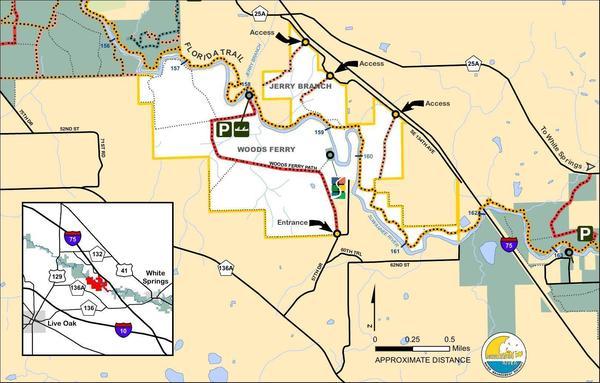
Put In: Mile 158.0, Woods Ferry Tract Launch, in Suwannee County, Florida
GPS of Entrance: to Woods Ferry Tract 30.343508, -82.855187
Paddle Distance: 8.0 river miles
Paddle Duration: 4 hours
Directions to Put In:
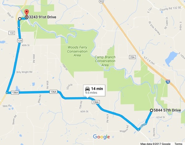
From Live Oak, travel north on
US 129 to CR 136A; turn right; travel
east to 57 Drive; turn left and continue north to Woods Ferry
Path; follow Woods Ferry Path to Woods Ferry Tract Launch.
Do NOT go upstream to Woods Ferry Camp Boat Ramp;
we won’t be there!
Or meet up with Phil Hubbard at the Love’s Truck Stop at exit 451 at 8:00; he will depart from there at 8:15.
GPS of Put In:
Do NOT use these coordinates for road routing; 30.36200, -82.86833;
online maps will take you to the wrong side of the river!

SRWMD
Map
of
Woods Ferry Tract.
See also the aerial photographs by Beth Gammie.
Take Out:
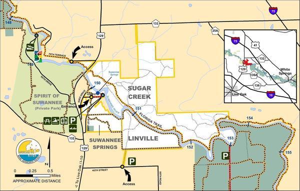
Mile 150.0, Suwannee Springs Launch,
From Live Oak, travel north on US 129 to 93rd Drive; turn right; travel north to 32nd Street; turn right and follow to park area.
Do NOT take 91st Lane: it does not go to the entrance.
GPS of Take Out: 30.39416, -82.93383

SRWMD Map of
http://www.srwmd.state.fl.us/index.aspx?nid=168″>Suwannee Springs Tract.
See also the aerial photographs by Beth Gammie.
Shuttle Distance: 9 miles one way
Shuttle Duration: 16 minutes one way, 40 minutes total
Gage: White Springs, FL, which on May 17th was at 48.71 feet, with flood at 76 feet and empty at about 48 feet.
Host and Contact: WWALS Outings Committee Chair Phil Hubbard, (229) 740-2016
Maybe you’d like to apply to join the
WWALS Outings Committee.
No boat? No problem! Let us know in advance and probably somebody can loan you one. Or there are many outfitters; see separate web page.
Backup: in case of high or low water is to hike Big Shoals from Big Shoals Tract Launch, 30.352414, -82.687889: from White Springs, travel north on CR 135 to SE 94 Street (Godwin Bridge Road); turn right and follow road to Big Shoals.
For more outings and events as they are posted, see the WWALS calendar.
-jsq, John S. Quarterman, Suwannee RIVERKEEPER®
You can join this fun and work by becoming a WWALS member today!
Short Link:


Pingback: White Springs to Blue SInk Swift Creek Launch, Suwannee River, 2017-05-20 | WWALS Watershed Coalition (Suwannee RIVERKEEPER®)
Pingback: Water low but passable, White Springs to Swift Creek, Suwannee River 2017-05-20 | WWALS Watershed Coalition (Suwannee RIVERKEEPER®)
Pingback: Aerials: Woods Ferry Tract to Suwannee Springs 2016-11-23 | WWALS Watershed Coalition (Suwannee RIVERKEEPER®)
Be sure to follow directions and not GPS coordinates. If you are directionally challenged, you can meet me at the Loves Truck Stop at I-75 exit 451 at 8:00 AM and depart at 8:15 AM. The put in is 30 minutes from this exit.