
Climbing to Five Holes caves


Bring bon-bons, lights, and boats to
Banks Lake, just west of Lakeland, Georgia,

7PM Saturday
August 29th 2015
for the first WWALS Moonlight Paddle and Bon-Bon Eating Contest. Your host, Chris Mericle, has arranged a special after-hours permit for this outing. Join us at
Banks Lake Outdoors,
1099 W Main St.,
Lakeland, GA 31635.
This is part of our continuing exploration of the Alapaha River Water Trail. Printable PDF flyer. facebook event.
Strictly speaking, a bon-bon is Continue reading
Expedition leader Chris Mericle reports he’s gotten the Suwannee River State Park vehicle entrance fees waived for this weekend’s outing, plus a permit
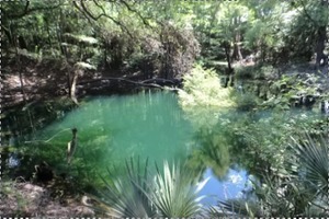
…to view a unique closed area of the park called “5 Holes”. 5 Holes is a series of karst windows leading to a spring. When the water level is right you can walk through a semi-cavern from the river up the spring run to the spring.
So meet us 8AM tomorrow morning, Saturday, August 15h, 2015 at Gibson Park!
James Garrett posted some Continue reading
Drilling down in Brooks County, under the Withlacoochee River,
 the CSX Railroad,
and Old Quitman Highway, surfacing in Lowndes County, Sabal Trail has moved its proposed Withlacoochee HDD crossing upstream.
The actual river crossing appears to be at about
30.795273, -83.452722.
the CSX Railroad,
and Old Quitman Highway, surfacing in Lowndes County, Sabal Trail has moved its proposed Withlacoochee HDD crossing upstream.
The actual river crossing appears to be at about
30.795273, -83.452722.
This is all according to Continue reading
The
Florida Springs Council (FSC) is concerned about Bill Gates,
 Lakeland Sands and others investing in Florida and south Georgia Land
for industrial farming operations, reports
Chris Mericle, WWALS delegate to FSC.
FSC, like WWALS, would like to know more, and is trying to contact Bill Gates
to start a dialog about sustainable farming practices.
Lakeland Sands and others investing in Florida and south Georgia Land
for industrial farming operations, reports
Chris Mericle, WWALS delegate to FSC.
FSC, like WWALS, would like to know more, and is trying to contact Bill Gates
to start a dialog about sustainable farming practices.
For example, Chris reports:
There is a 300 acre parcel of Lakeland Sands property here in Hamilton Co. that has been cleared of the forest that was there except for a small island of trees in the center. Within this island of trees is a true hydrogeological wonder. A beautiful spring boils from the ground, the spring pool is Continue reading
Do we want to risk Sabal Trail’s fracked methane pipeline blowing out
under the Suwannee or Withlacoochee Rivers like
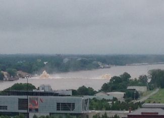 Spectra’s Texas Eastern Pipeline blew out under the Arkansas River in May?
WWALS doesn’t, which is why we filed the
petition to Florida’s Department of Environmental Protection
asking them not to issue a permit for Sabal Trail.
Spectra’s Texas Eastern Pipeline blew out under the Arkansas River in May?
WWALS doesn’t, which is why we filed the
petition to Florida’s Department of Environmental Protection
asking them not to issue a permit for Sabal Trail.
The Little Rock blowout is one of several recent Spectra incidents Dan Christensen finds today in FloridaBulldog.org, Pipeline company with tie to Gov. Scott, and state backing, has history of accidents, Continue reading