
Drilling through fragile sinkhole-prone
 karst limestone under the Withlacoochee River (or the Suwannee River,
or the Santa Fe River): what could possibly go wrong?
Sabal Trail now proposes to move off of the Withlacoochee River in
Florida, but still plans to cross the Withlacoochee in Georgia,
and to cross the Suwannee and Santa Fe Rivers, all of which have
the same hydrogeology.
You can talk directly to Sabal Trail and FERC at the
Open House in Jasper, Florida, 5-7PM Tuesday 21 October 2014,
and you can join WWALS where the Alapaha River
disappears entirely into a sinkhole,
at the
Alapaha Sink, 2PM Sunday 26 October 2014.
karst limestone under the Withlacoochee River (or the Suwannee River,
or the Santa Fe River): what could possibly go wrong?
Sabal Trail now proposes to move off of the Withlacoochee River in
Florida, but still plans to cross the Withlacoochee in Georgia,
and to cross the Suwannee and Santa Fe Rivers, all of which have
the same hydrogeology.
You can talk directly to Sabal Trail and FERC at the
Open House in Jasper, Florida, 5-7PM Tuesday 21 October 2014,
and you can join WWALS where the Alapaha River
disappears entirely into a sinkhole,
at the
Alapaha Sink, 2PM Sunday 26 October 2014.
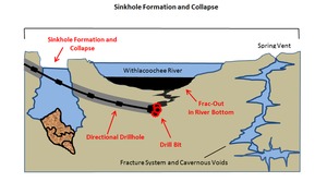
Here are before and after diagrams by
David Brown, 22 August 2014,
 in his
Hydrogeology Report: Sabal Trail methane pipeline crossing of Withlacoochee River.
Sabal Trail proses to use horizontal directional drilling or HDD
under these rivers, which already have springs, sinkholes, and caves
in copious fracture systems.
in his
Hydrogeology Report: Sabal Trail methane pipeline crossing of Withlacoochee River.
Sabal Trail proses to use horizontal directional drilling or HDD
under these rivers, which already have springs, sinkholes, and caves
in copious fracture systems.
What happens if the drill bit encounters one or more of those? Potentially sinkhole formation, or collapse into an underground cavern. Such a hydrofracture, or frac-out would form a hole from the surface into the Floridan Aquifer, which is the source of all our drinking water.

Cross-section of the proposed HDD crossing of the Withlacoochee River and hypothetical karst features that could result in a hydrofracture (frac-out).

Potential sinkhole or collapse feature forming as a result of the proposed HDD crossing of the Withlacoochee River.
 Here is Chris and Deanna Mericle’s
video of springs and sinkholes
on the Withlacoochee River near where Sabal Trail proposes to drill.
Many of us paddled up to those springs and felt their cool waters
21 September 2014.
FERC and Sabal Trail drove and walked there
9 September 2014.
Here is Chris and Deanna Mericle’s
video of springs and sinkholes
on the Withlacoochee River near where Sabal Trail proposes to drill.
Many of us paddled up to those springs and felt their cool waters
21 September 2014.
FERC and Sabal Trail drove and walked there
9 September 2014.
 Partly due to this very hydrogeology report,
Sabal Trail now proposes
to move off of the Withlacoochee River in Hamilton County, Florida.
Partly due to this very hydrogeology report,
Sabal Trail now proposes
to move off of the Withlacoochee River in Hamilton County, Florida.
But it does not propose to move off the Withlacoochee River in Brooks or Lowndes Counties, Georgia.
 The USGS warned us way back in 1999 that
the Withlacoochee River already leaks into the Floridan Aquifer,
especially just north of Valdosta, not far from Sabal Trail’s
Alternative 4.
That’s why Valdosta’s wells are 400 feet deep: to get underneath
the level of the Floridan Aquifer that receives that river water.
And
Prof. Don Thieme showed WWALS at VSU 9 October 2013
the
Cherry Creek Sink,
which he said formed within about a month next to the Withlacoochee River.
The USGS warned us way back in 1999 that
the Withlacoochee River already leaks into the Floridan Aquifer,
especially just north of Valdosta, not far from Sabal Trail’s
Alternative 4.
That’s why Valdosta’s wells are 400 feet deep: to get underneath
the level of the Floridan Aquifer that receives that river water.
And
Prof. Don Thieme showed WWALS at VSU 9 October 2013
the
Cherry Creek Sink,
which he said formed within about a month next to the Withlacoochee River.
 As you can see, it is quite a bit bigger than Cherry Creek,
and it goes down into the aquifer.
As you can see, it is quite a bit bigger than Cherry Creek,
and it goes down into the aquifer.
Why would it matter if a drill caused another sinkhole, when there are already so many? See above about Valdosta had to drill its wells hundreds of feet deeper. How many other wells might a new frac-out aquifer window contaminate? And with what drilling fluids from a company previously fined $15 million by the EPA for PCB spills at 89 sites, and another $18.6 million by Pennsylvania plus $200 million for cleanup?
The Suwannee and Santa Fe Rivers are also in the same geological formations.
You can come to the Sabal Trail Open House in Jasper, FL 5-7PM Tuesday 21 October 2014 and tell Sabal Trail and FERC and the news media what you think of that.
 Plus you don’t have to go anywhere to
file an ecomment with FERC,
or to
contact your local, state, or national elected and appointed officials
or to write a letter to the editor of your newspaper or to call in to
a radio talk show.
Plus you don’t have to go anywhere to
file an ecomment with FERC,
or to
contact your local, state, or national elected and appointed officials
or to write a letter to the editor of your newspaper or to call in to
a radio talk show.
Come see a sinkhole swallow a river whole, at the Alapaha Sink, 2PM Sunday 26 October 2014. No boats required: this is a walking outing.
-jsq
Short Link:
Pingback: GWC DD#9: Sabal Trail pipeline threatens Withlacoochee River and Floridan Aquifer - WWALS Watershed Coalition
Pingback: WCTV on Sabal Trail pipeline activism | On the LAKE front