Tag Archives: Georgia Department of Transportation

Fundraising for Water Trail signs

Update 2025-06-04: Prices for road signs have tripled (due to price of steel tripling) and at-water signs also cost more.

Update 2019-11-08: Donate through GA Gives, including if you wish for Brochures.

Update 2019-04-26: Price of metal signs at the water at boat ramps and landings. Just the signs, Westbound

Update 2018-04-27: Pictures of Lakeland Boat Ramp signs in the ground.

Update 2018-03-15: People want to know how much the signs cost:

  • Road Signs
    • $150 $500 road signs for one signpost (one direction)
    • $300 $1,000 pair of road posts with signs for a landing or boat ramp
  • Signs at the water near a boat ramp or landing: if you donate for a specific location, your logo can go on the signs there, and on the water trail brochures and web pages
    • $600 one park-style kiosk, or
    • $50 $70 pair of metal signs with 4×4 post, bolts, and concrete.

Any amount of donation helps put up the road signs that let people know the Alapaha River Water Trail (ARWT) exists and directs them to the landings, as well as the kiosks that inform people about what to expect nearby, so we get more people paddling the Alapaha River who will take care of the river.

The pair of metal signs at the water also work for the Withlacoochee and Little River Water Trail (WLRWT). Here is an example pair of metal signs at the water for Troupville Boat Ramp:

[Side by Side]
Side by Side

The Alapaha River Water Trail (ARWT) is a reality. We are ordering have bought the road signs from the Georgia Department of Transportation (GDOT) which has planted them on roads leading to landings, and we need to pay for them. We have a small amount of money from Continue reading

For development, or not needed? US 84 widening from Homerville to Waycross

This paragraph sums it up:

300x388 Wetlands 29 and 31, in RE: SAS-2014-00862, Proposed U.S. Highway 84 Widening, by Gilbert B. Rogers, for WWALS.net, 28 May 2015 The project’s stated purpose in the EA is “economic development,” as part of the Governor’s Road Improvement Program created in the 1980s. See EA at 4. The NEPA regulations promulgated by the Council on Environmental Quality (“CEQ”) require agencies to examine the indirect impacts of projects — those growth-inducing impacts caused by a project, such as changes in land use and development patterns. 40 C.F.R. § 1508.8(b). Yet over and over, when purporting to examine the project’s potential for indirect impacts on various natural resources, the EA repeats, “The proposed project is not expected to precipitate substantial development along the corridor.”

Other questions include, why not use a narrower median? Why not leave trees on the median?

Below is the full text of the letter Continue reading

Widening US 84 from Homerville to Waycross

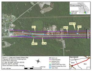
300x232 Figure 4.1: State and Federal Waters Map, in US 84 four-laning from Homerville to Waycross, by John S. Quarterman, for WWALS.net, 28 April 2015 GDOT and the Army Corps want to widen U.S. 84 from Homerville to Waycross. Since it appears that US 84 is already four lane from Thomasville through Quitman and Valdosta to Homerville, and from Waycross onwards northeast, this would be the remaining gap. The public notice says little or nothing about why this road work might be needed.

U.S. Army Corps of Engineers, Public Notice, 28 April 2015, SAS-2014-00862 (SP-WMR), Widening and Reconstruction of U.S. Highway 84, with PDF. Since that notice says it expires in a month, there’s also a copy of the PDF on the WWALS website, including this location information: Continue reading