Tag Archives: karst limestone

Karst Hazard Mitigation, George C. Fisher to Lowndes County Commission 2026-10-13

George Fisher sent this paper, asking for WWALS to publish it before he presents it to the Lowndes County Commission at their Regular Session this evening, Tuesday, October 13, 2026, at 5:30 PM, 327 North Ashley Street, Valdosta, GA 30601.

https://www.l-a-k-e.org/blog/?p=26113

You can also come speak in Citizens Wishing to Be Heard.

Since George’s paper is about water issues, I’m posting it.

George is not a WWALS member, and all opinions in his document are his.

[Karst Hazard Mitigation, George C. Fisher, to Lowndes County Commission, 2026-10-13]
Karst Hazard Mitigation, George C. Fisher, to Lowndes County Commission, 2026-10-13

[To:] Lowndes County Board of Commissioners Meeting
October 13, 2026
George C. Fisher
Subject: Karst Hazard Mitigation

Map of Karst Locations in the US (Epstein et al 2002)

Proposed Action Request

Continue reading →

Lowndes County did no groundwater sinkhole study, yet asserts there have been only five sinkholes in the past 75 years 2026-09-25

Lowndes County may start doing a ground study of sinkholes in 2027, after not doing one that should have wrapped up in 2021.

How can the county write an effective datacenter ordinance with no study of sinkholes in the karst-limestone underlying Lowndes County? Sinkholes such as have sunk a county road and forced Valdosta to dig its water wells deeper?

As the county’s recently-adopted Hazard Mitigation Plan says on page 71,

The region immediately north and northwest of the City of Valdosta is an active, heavily documented covered-karst zone. Because the overlying soil and sand layers are relatively thin or permeable here, acidic rainwater and river overflow rapidly dissolve the underlying limestone. This causes high sinkhole susceptibility. Places like Snake Nation Road northwest of Valdosta have suffered severe road-swallowing sinkholes because of this collapsing bedrock.

That is the region with the rezoned M-1 property likely for a hyper-scale AI datacenter.

[Lowndes County did no groundwater sinkhole study, yet says there were only five sinkholes in the past 75 years]
Lowndes County did no groundwater sinkhole study, yet says there were only five sinkholes in the past 75 years

The new Hazard Mitigation Plan that the county adopted on September 22, 2026, asserts that only five sinkholes have been reported between January 1, 1950, and July 31, 2026.

I have personally seen more new sinkholes than that in the past dozen or so years. Including the Rustic Ridge Road sinkhole that County Manager Paige Dukes refered to as “a cavern” yet is not included in this Plan’s list of sinkholes. Also the Cherry Creek Sink that appeared in the Withlacoochee River within a few months in 2013. And the sinkhole under a garage on Norman Hall Road that formed around 2012.

Yet the Lowndes County Commissioners and Staff plan to complete a datacenter ordinance before their 60-day datacenter moratorium expires on October 16, 2026.

How can Lowndes County write a proper ordinance that takes into account sinkholes when, as the Plan also says:

The risk of developing caverns underground and close to the surface is unknown in Lowndes County. In southern Lowndes County, several sizable lakes formed from sinkholes. Smaller sinkholes have occurred in Valdosta. Because data and analysis are lacking, the true risk is unknown.

On September 25, 2026, I sent an open records request to Lowndes County: Continue reading →

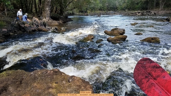
Shoals into out of Florida, Withlacoochee River 2017-10-14

The Withlacoochee River goes into and out of Florida twice before it makes up its mind. We saw karst, shoals, and rapids, into Florida and back to Georgia all downstream, Valdosta Railway Trestle, Madison County Four Freedoms Trail, and exotic invasive Japanese Climbing Fern, on a fall day on the Withlacoochee River with WWALS.

[White water, 2017-10-14, 13:58:34, 30.63457, -83.34178 --jsq for WWALS]
White water, 2017-10-14, 13:58:34, –jsq for WWALS 30.6345700, -83.3417800

This is Part 2, after Continue reading →

Dirty Dozen, sinkhole, aquifer, drinking water, and corrosion –WWALS to FERC about Sabal Trail

“There is no reason anyone in WWALS’ watersheds should accept any risk for the profit of Williams Company, Spectra Energy, and FPL, when any need for the Sabal Trail pipeline is unproven, and in any case the pipeline does not serve anyone in Georgia.”

Filed with FERC 15 November 2014, and appeared in FERC’s ecomment system 17 November 2014 (PDF).

WWALS Watershed Coalition, Inc.
3338 Country Club Road #L336
Valdosta, GA 31605
15 November 2014

VIA ELECTRONIC FILING
Ms. Kimberly Bose
Federal Energy Regulatory Commission
888 First Street NE
Washington, DC 20426

Re: Southeast Market Pipelines Project,
Sabal Trail Transmission, LLC Docket No PFl4-1-000
Williams Transco Hillabee Expansion Project, LLC Docket No PFl4-6-000

Dear Ms. Bose,

I applaud FERC for getting Sabal Trail to move off of the Withlacoochee River in Hamilton County, Florida. However, the same karst limestone geology underlies the same Withlacoochee River and the Floridan Aquifer in Brooks and Lowndes Counties, Georgia, and WWALS Watershed Coalition continues Continue reading →