Wondering why Valdosta is having an overflow problem? It was rain on Valdosta, and north of Valdosta.
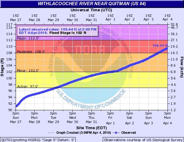
Not so much northwest on the Little River, nor even west on Okapilco Creek: Continue reading

Wondering why Valdosta is having an overflow problem? It was rain on Valdosta, and north of Valdosta.
Not so much northwest on the Little River, nor even west on Okapilco Creek: Continue reading
More than 1,000 acres through September 2014, in parcels already adding up to more than 250 acres, or in contiguous or nearby parcels that can be combined, all bought by Lakeland Sands LLC.
 On SE Farm Road and FL 63, between Madison and Lee, 30.423520, -83.353757,
parcels 01-1S-09-0843-000-000 (374 acres),
06-1S-10-1192-000-000 (568.35 acres),
05-1S-10-1187-000-000 (363.161 acres),
07-1S-10-1197-000-000 (316.13 acres),
08-1S-10-1199-000-000 (259 acres)
12-1S-09-0892-001-000 (67.27 acres)
12-1S-09-0893-000-000 (224.68 acres),
and
11-1S-09-0884-000-000 (162.93 acres),
for
2335.52 acres
total in just those eight parcels.
All eight marked as timberland: we’ll see how long that lasts.
Plus 12-1S-09-0892-002-0A2 (39.12 acres) of pastureland in between.
These parcels surround a couple of City of Madison parcels Continue reading
On SE Farm Road and FL 63, between Madison and Lee, 30.423520, -83.353757,
parcels 01-1S-09-0843-000-000 (374 acres),
06-1S-10-1192-000-000 (568.35 acres),
05-1S-10-1187-000-000 (363.161 acres),
07-1S-10-1197-000-000 (316.13 acres),
08-1S-10-1199-000-000 (259 acres)
12-1S-09-0892-001-000 (67.27 acres)
12-1S-09-0893-000-000 (224.68 acres),
and
11-1S-09-0884-000-000 (162.93 acres),
for
2335.52 acres
total in just those eight parcels.
All eight marked as timberland: we’ll see how long that lasts.
Plus 12-1S-09-0892-002-0A2 (39.12 acres) of pastureland in between.
These parcels surround a couple of City of Madison parcels Continue reading
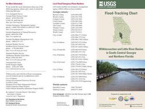 An interesting flyer pointed out by Emily Davenport,
Storm Water Utilities Director, City of Valdosta.
It has many useful
contacts on the front,
and
tips on the back (don’t walk or drive through flood waters)
but the most useful part is
inside,
where the flood-tracking chart is, in
Flood-tracking chart for the Withlacoochee and Little River Basins in south-central Georgia and northern Florida,
2014, by Gotvald, Anthony J.; McCallum, Brian E.; Painter, Jaime A.,
USGS General Information Product: 155.
An interesting flyer pointed out by Emily Davenport,
Storm Water Utilities Director, City of Valdosta.
It has many useful
contacts on the front,
and
tips on the back (don’t walk or drive through flood waters)
but the most useful part is
inside,
where the flood-tracking chart is, in
Flood-tracking chart for the Withlacoochee and Little River Basins in south-central Georgia and northern Florida,
2014, by Gotvald, Anthony J.; McCallum, Brian E.; Painter, Jaime A.,
USGS General Information Product: 155.
Here are the gages mentioned in the chart, with links to the live USGS FloodTracking pages, Continue reading