Tag Archives: flood

No testing due to rivers in flood and hurricane obstructions in roads 2023-08-31

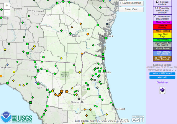
For the first time in years, there is no WWALS weekly water quality report this week.

[Rivers in flood, deadfall on power lines on road]
Rivers in flood, deadfall on power lines on road

We did not sample yesterday, because:

  • After Hurricane Idalia, many roads are still obstructed by downed trees and power lines.
  • The Withlacoochee River was in flood, and the Alapaha is heading up there.

For the above reasons, we would not recommend fishing, swimming, or boating this weekend on the Withlacoochee or Alapaha Rivers. The Little River is not in flood, but it’s pretty high and fast. On all three rivers, in addition to the usual flood issues, there are likely to be new deadfalls.

The Santa Fe, Ichetucknee, and Suwannee Rivers were much less affected, so if you want to go out this weekend, please go there.

The only sewage spill so far reported in the Suwannee River Basin in Georgia or Florida is Continue reading

Flooding on the Suwannee River at Suwannee Springs –SRWMD 2021-09-23

Like me, you may be wondering what is going on at Suwannee Springs since I first reported on the debris there after the July 2020 flooding. In January 2021, the answer was SRWMD would finishing removing the debris “in a few weeks, not months.”

Unfortunately, then there was repeated flooding, and in between floods the COVID-19 pandemic interfered.

So yesterday I asked again, and today Edwin McCook took this picture:

[Flooding on the Suwannee River at Suwannee Springs on 9/23/2021. Suwannee; Springs gauge 53.86'. Photo: Edwin McCook, SRWMD]
Flooding on the Suwannee River at Suwannee Springs on 9/23/2021. Suwannee; Springs gauge 53.86′. Photo: Edwin McCook, SRWMD

As you can see, the river water is close to the top of the spring wall.

Edwin says once the water recedes, the Suwannee River Water Management District (SRWMD) will continue planning to remove the debris. They had already reviewed options back in January, so they have a leg up on that planning.

More when I know more.

Meanwhile, the Suwannee Springs USGS gauge reads 53.86′.

That’s well below flood stage, which is 60′. However, you can see by the picture that working inside the spring wall would be difficult with the water that high. Continue reading

Withlacoochee River flood paddle 2021-02-27

Update 2023-02-15: Paddling in the treetops 2023-02-13 and for real two years ago 2021-02-27 2023-02-13.

Some of us paddled anyway back in February, after we first rescheduled the Mayor’s Paddle, which is coming up next weekend, Saturday, March 27, 2021. Two months earlier, it was smooth sailing for experienced paddlers. The overhanging branches would have been a problem for novices, and there were very few places to get out if you did capsize.

But the Withlacoochee River should be just right by this Saturday, so come on along!
https://wwals.net/?p=54923

You’ll get to see the Little River Confluence, future site of Troupville River Camp, when it’s not underwater, as well as the Withlacoochee Wastewater Treatment Plant Outfall (of clean treated water), Millrace Creek and other creeks, as well as three bridges, including our takeout just below Spook Bridge. Thanks to The Langdale Company for access there and at the lunch stop.

WWALS is happy to have Valdosta Mayor Scott James Matheson as our guest. He will speak before we paddle, as will Lowndes County Chairman Bill Slaughter. We are inviting nearby county and city officials in Georgia and Florida, as well as statehouse and Congress members. Each elected official will get three minutes to speak.

[Left: Smooth paddling, Mayor at WWTP Outfall, Sunny overhanging limbs, Buzzards, Lunch stop with Russell's turtle, Spook Bridge]
Left: Smooth paddling, Mayor at WWTP Outfall, Sunny overhanging limbs, Buzzards, Lunch stop with Russell’s turtle, Spook Bridge

[Need a bigger boat, Mayor?, 09:06:29, 30.8515344, -83.3478232]
Need a bigger boat, Mayor?, 09:06:29, 30.8515344, -83.3478232

I will say a few words about advocacy, especially water quality testing. Expedition leader Bobby McKenzie will give the safety lecture. Then we will paddle!

Click on any small picture to see a larger one. Continue reading

Spook Bridge in minor flood, Withlacoochee River 2021-02-23

The Withlacoochee River is a tad high for novice paddlers.

[Takeout flooded, eddies upstream, boat parking flooded, muddy entrance road]
Takeout flooded, eddies upstream, boat parking flooded, muddy entrance road

Yesterday the Withlacoochee River was at 107.5′ NAVD 1988 (feet above sea level), or 24′ old-style above the riverbed. Minor flood stage starts at 104′, and Action stage at 99′. With no more rain predicted this week, currently it’s expected to be down about 100.5′ by Saturday noon. Continue reading

Suwannee Springs flood debris 2021-01-12

Update 2021-09-23 Flooding on the Suwannee River at Suwannee Springs –SRWMD 2021-09-23.

Many people have wondered when SRWMD will finish cleaning the debris out of Suwannee Springs from the flood last July. Probably in a few weeks, not months.

Yesterday at the invitation of Edwin McCook of the Suwannee River Water Management District I went to see the problem. He and I and his consultant discussed the problem.

As you can see, getting that rammed-in driftwood out of all that dirt and sand would be quite a task to do by hand. Edwin decided to start with larger equipment. The catch is how to get it in there, and what can fit. He and the consultant are working up a plan.

There will still be need for volunteers to do manual cleanup, since the big equipment can’t get everything. Stay tuned, and we’ll let you know when that will happen. It will probably be several weeks yet.

[Down the steps]
Down the steps

Continue reading

Suwannee Springs work in progress 2020-07-22

Update 2021-01-13: It’s complicated, but a plan is in the making, and volunteers will be wanted in a few weeks.

The Suwannee River Water Management District (SRWMD) is removing the debris from Suwannee Springs that was left by recent flooding of the Suwannee River.

[Four views of Suwannee Springs]
Four views of Suwannee Springs

When I spoke to Edwin McCook, SRWMD Sr. Land Management Specialist, yesterday, he mentioned that SRWMD is looking into further improvements beyond just the debris removal and fixing the staircase mentioned in the SRWMD PR below. It will probably take a few weeks to decide what more can be done. When we know more, I’ll post more. Continue reading

2009 Withlacoochee River flooding of caterer location for Paddle Georgia Final Feast 2009-04-09

The Withlacoochee River hasn’t risen like this since The Salty Snapper moved in, which is good, since they’re catering the Final Feast tonight on the Suwannee River in Suwannee County, Florida for the last day of #PaddleGA2019, after we paddle in at the Hal W. Adams Bridge Boat Ramp in Lafayette County.

[Canoe to the door]
Canoe to the door

Donald O. Davis of the Lowndes County Historical Society writes:

The caterer’s building and the 2009 Withlacoochee flood. The original long-running restaurant in the location was JP Muldoons. The Salty Snapper opened in 2015.

[WLRWT]
Map: WWALS google map of the Withlacoochee and Little River Water Trail (WLRWT).
The Salty Snapper is just east of Continue reading

Suwannee tributaries flooding 2018-08-07

Once again, as during Hurricane Irma, recent rains are causing flooding on Suwannee River tributaries.

Suwannee River Basin, Map

The Withlacoochee River at Skipper Bridge and at US 41 (North Valdosta Road) is in Near Flood Stage, as is the Suwannee River at Fargo, and the New River near Lake Butler.

Already in Minor Flooding are Continue reading

Impervious surface from development causes flooding

Could similar development in the Suwannee River watershed have something to do with the 700-year floods in 2009 and 2013?

Georgia State University, PR, December 6, 2017 Researchers Find Urban Development Dramatically Increases Stream Flow,

Fig. 1 watersheds

…Between 1992 and 2011, the amount of developed land in these watersheds also doubled, almost entirely at the expense of forest land.

In both watersheds, this urbanization led to Continue reading

Sinkhole, Sabal Trail, Okapilco Creek, Brooks County, GA 2017-09-19

Update 2017-09-21: Yes, I reported it to GA-EPD, et al. (PDF), and here are facebook photos of most of the images below.

How close to exposed is Sabal Trail’s pipe? This sinkhole is at least a foot deep, maybe two or more, and Sabal Trail only buried their pipe three feet deep, despite requests by Brooks, Colquitt, and Lowndes Counties to bury it deeper.

At sinkhole, Sinkhole

N of sinkhole, Sinkhole

Is that fill material exposed Continue reading