Tag Archives: Pinetta

River Low, Action, and Flood Stages 2023-02-16

“What does “action stage” mean?” asked Christy Yates on facebook about Paddling in the treetops 2023-02-13 and for real two years ago 2021-02-27 2023-02-13.

This is relevant to the upcoming Fourth Annual Mayor and Chairman’s Paddle, Withlacoochee River 2023-03-04.

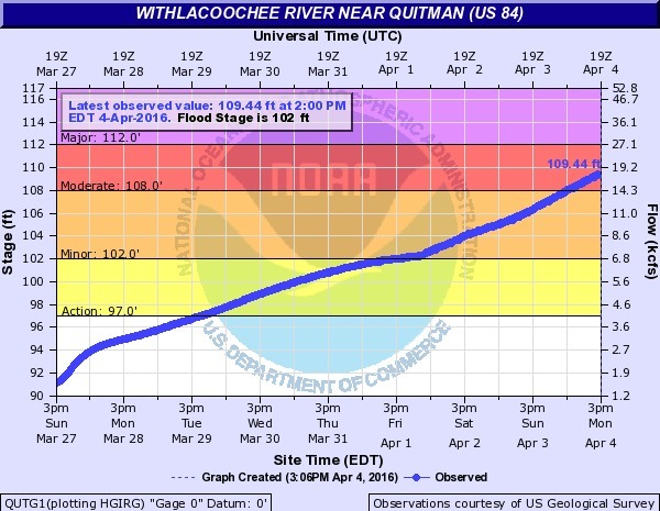
I answered: Basically, watch out, the river is high. More formally: “Action Stage – the stage which, when reached by a rising stream, represents the level where the NWS or a partner/user needs to take some type of mitigation action in preparation for possible significant hydrologic activity. The type of action taken varies for each gage location. Gage data should be closely monitored by any affected people if the stage is above action stage.

[Stages, US 84 Gauge, Treetop paddling]
Stages, US 84 Gauge, Treetop paddling

See below for National Weather Service (NWS) terminology, which also defines several stages of flooding: minor, moderate, and major. That definitions web page is from Alaska, and it includes something called “bankfull stage” that I’ve never seen used around here. The rest of it is the same as in the Suwannee River Basin.

Right now paddling the Withlacooche River would be up in the branches like this picture, but higher. Don’t worry: the water level will probably go back down before March 4th. Continue reading

Four Freedoms Trail, Madison, FL to Withlacoochee River

Paddling down the Withlacoochee River from Nankin to Mozell Spells, the remains of the Valdosta Railway Bridge mark on the right bank the north end of the Four Freedoms Trail, one of the few hiking trails on the Withlacoochee and Little River Water Trail (WLRWT):

Valdosta Railway trestle
Photo: John S. Quarterman for WWALS, 9 July 2016.

The Four Freedoms Trail in Madison County was constructed as a joint effort between Continue reading

State line to Sullivan Launch, Withlacoochee River 2016-10-09

Sunday morning on the tea-colored Withlacoochee River in north Florida in fall: come join us!

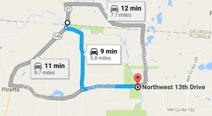
Shuttle When: 10AM Sunday October 9th 2016

Put in: Madison Highway on the Georgia side, also known as GA 31 Ramp (SRWMD) or State Line Ramp (GA DNR) or CR 145 Bridge Launch (FDEP). 30.635933, -83.311103

Directions: Continue reading

Flooding at Valdosta, 2016-04-04

Wondering why Valdosta is having an overflow problem? It was rain on Valdosta, and north of Valdosta.

US 84, Withlacoochee River

Not so much northwest on the Little River, nor even west on Okapilco Creek: Continue reading

Water Resources of the upper Suwannee River Watershed

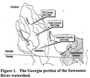
Even the trend of sinking groundwater levels hasn’t changed a lot in the Georgia parts of WWALS’ watersheds of the Withlacoochee, Alapaha, and upper Suwannee Rivers. Figure 1: Georgia Watersheds Thanks to Tom Potter for the pointer, and we’re inviting someone to talk about this subject at the Withlacoochee and Little River Water Trail Workshop at VSU February 27th, 2016.

WATER RESOURCES OF THE UPPER SUWANNEE RIVER WATERSHED, by Mary M. Davis1 and David W. Hicks2,

1 Ecologist, Continue reading

USGS Flood-Tracking Chart for Withlacoochee and Little River Basins

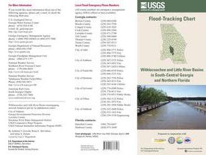
An interesting flyer pointed out by Emily Davenport, Storm Water Utilities Director, City of Valdosta. It has many useful contacts on the front, and tips on the back (don’t walk or drive through flood waters) but the most useful part is inside, where the flood-tracking chart is, in Flood-tracking chart for the Withlacoochee and Little River Basins in south-central Georgia and northern Florida, 2014, by Gotvald, Anthony J.; McCallum, Brian E.; Painter, Jaime A., USGS General Information Product: 155.

Here are the gages mentioned in the chart, with links to the live USGS FloodTracking pages, Continue reading