Rivers and streams cover more of the earth’s surface than previously thought,
and likely interchange more CO2 and other gases with the atmosphere
than previously thought.
WWALS Science Committee Chair Tom Potter found this paper.
George H. Allen and Tamlin M. Pavelsky,
Science, 28 Jun 2018, DOI: 10.1126/science.aat0636
Global extent of rivers and streams,
Abstract
The turbulent surfaces of rivers and streams are natural hotspots of
biogeochemical exchange with the atmosphere. At the global scale,
the total river-atmosphere flux of trace gasses such as CO2 depends
on the proportion of Earth’s surface that is covered by the fluvial
network, yet the total surface area of rivers and streams is poorly
constrained. We used a global database of planform river
hydromorphology and a statistical approach to show that global river
and stream surface area at mean annual discharge is 773,000 ±
79,000 km2 (0.58 ± 0.06%) of Earth’s non-glaciated land surface, an
area 44 ± 15% larger than previous spatial estimates. We found that
rivers and streams likely play a greater role in controlling
land-atmosphere fluxes than currently represented in global carbon
budgets.

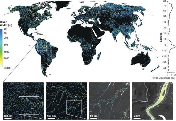
Fig. 1. The Global River Widths from Landsat (GRWL) Database
contains more than 58 million measurements of planform river
geometry. The line plot on the right shows observed river coverage
as a percentage of land area by latitude, and the bottom insets show
GRWL at increasing zoom. The rightmost inset shows GRWL orthogonals
over which river width was calculated, with only every eighth
orthogonal shown for clarity.
You can see the lower Suwannee River in the above figure.
The authors zoom in on the Amazon
River Basin in Brazil, but those last two zooms could easily be Continue reading →
![[Plastic bag bans keep trash out of rivers and the sea --a study in Science, June 19, 2025]](https://www.wwals.net/pictures/2025-06-19--plastic-bag-ban-benefits-science/fbmany.jpg)


