Downstream from Valdosta and Tifton on the Withlacoochee River, and downstream from Fitzgerald on the Willacoochee River: room for improvement in fecal coliform,
 said the Georgia Environmental Protection Division in a draft report issued Friday.
The comment deadline is January 20th, 2016.
On a quick read, the various wastewater treatment plants do not seem to be the main source of the contamination.
Other likely culprits include leaking septic tanks, concentrated livestock operations, and landfills and land application sites, both closed and operating.
Also notice the proposed Sabal Trail fracked methane pipeline would cross most if not all of these TMDL locations in Lowndes County.
Would drilling under the Withlacoochee River and open cuts in these areas help the TMDL problem?
Here’s the NOTICE OF AVAILABILITY OF PROPOSED TOTAL MAXIMUM DAILY LOADS FOR WATERS AND POLLUTANTS OF CONCERN IN THE STATE OF GEORGIA November 20, 2015, which includes:
Notice is hereby given that the State of Georgia has developed proposed Total Maximum Daily Loads (TMDLs) for fecal coliform for a number of segments of rivers and streams in the Satilla and Suwannee River Basins.
Section 303(d)(1)(C) of the Clean Water Act (CWA), 33 U.S.C. 1313(d)(1)(C), and the U. S. Environmental Protection Agency implementing regulation, 40 C.F.R. 130.7(c)(1), require the establishment of TMDLs for waters identified in accordance with Section 303(d)(2)(A) of the CWA. Each TMDL is to be established at a level necessary to implement applicable water quality standards with seasonal variations and a margin of safety. TMDLs are proposed for the following waters:
Satilla River Basin
Alabaha River, Hurricane Creek to Tan Trough Creek
East River, Academy Creek to Brunswick River
Otter Creek, Long Branch to Griffin BranchSuwannee River Basin
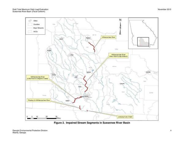
Jumping Gully Creek, Bevel Creek to State Line
Tributary to Withlacoochee River #2, Headwaters to Withlacoochee River
Willacoochee River, Turkey Branch upstream SR90/US Hwy 319 N of Ocilla to SR 90, SE of Ocilla
Withlacoochee River, Little River to Okapilco Creek
Withlacoochee River, New River to Bay Branch
The Satilla River is of course Satilla Riverkeeper territory.
The Suwannee River Basin in Georgia is WWALS territory.
The Notice links to the detailed descriptions. Then the Notice continues:
Written comments are welcomed. To insure their consideration, written comments should be received on or before 4:00 p.m., January 20, 2016. Written comments should be addressed to: Mr. Jac Capp, Branch Chief, Watershed Protection Branch, 2 Martin Luther King Jr. Drive, Suite 1152, Atlanta, Georgia 30334. Comments may be emailed to EPDComments@dnr.state.ga.us. If you choose to e-mail your comments, please be sure to include the words “TMDL Comments” somewhere in the subject line to help ensure that your comments will be forwarded to the correct staff.
For technical information contact Mr. Josh Welte, TMDL Modeling and Development Unit, Watershed Planning and Monitoring Program, (404) 463-4948.
After a review of comments, a final decision on each of the proposed TMDLs will be made and the proposed TMDL will be submitted to the USEPA for approval.
Please bring the foregoing to the attention of persons whom you believe will be interested in this matter.
The Suwannee Draft Fecal Coliform TMDL (November 2015) is on the state’s website, and also on the WWALS website.
Here’s the key table. Those are some large recommended reductions, from 70% for the Willacoochee River to 80% for Jumping Gully Creek!
| Stream Segment | Current | TMDL Components | Percent | ||||
|---|---|---|---|---|---|---|---|
|
Load
(counts/ 30 days) |
WLA
(counts/ 30 days) |
WLAsw
(counts/ 30 days) |
LA
(counts/ 30 days) |
MOS
(counts/ 30 days) |
TMDL
(counts/ 30 days) |
Reduction | |
| Jumping Gully Creek | 4.64E+12 | – | 2.91E+09 | 8.12E+11 | 9.06E+10 | 9.06E+11 | 80 |
| Tributary to Withlacoochee River #2 | 1.05E+12 | – | – | 2.48E+11 | 2.76E+10 | 2.76E+11 | 74 |
| Willacoochee River | 2.62E+14 | 1.15E+12 | – | 6.93E+13 | 7.83E+12 | 7.83E+13 | 70 |
| Withlacoochee River, Little River to Okapilco Creek | 1.04E+13 | 1.34E+12 | 9.43E+09 | 1.06E+12 | 2.68E+11 | 2.68E+12 | 74 |
| Withlacoochee River, New River to Bay Branch | 1.24E+14 | 1.68E+11 | 6.51E+10 | 2.90E+13 | 3.25E+12 | 3.25E+13 | 74 |
Figure 2. Impaired Stream Segments in Suwannee River Basin
For where those segments are, see Figure 2:
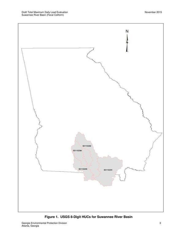
Figure 1. USGS HUCs for Suwannee River Basin
For any readers not familiar with those cities or streams, see the location map in Figure 1:
You may recognize those Hydrologic Unit Codes (HUCs) as the ones that define total WWALS territory in the application to Waterkeeper to include the upper Suwannee River HUC that Waterkeeper® Alliance accepted 15 July 2015. Note there are no TMDL recommendations in the upper Suwannee River HUC, and none in the Little River HUC nor on the Alapaha River proper. All the TMDL recommendations are downstream from cities or industry.
-jsq
You can join this fun and work by becoming a WWALS member today!
Short Link:


