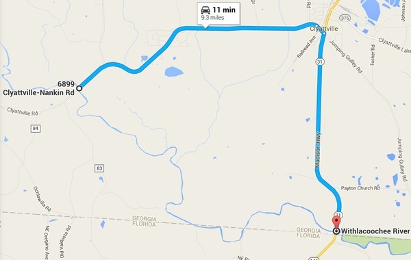
Shoals, creeks, and help us find MacIntyre Spring on the Brooks County side of the Withlacoochee River just before Florida.
 When: 8AM Saturday July 9th 2016
facebook event.
Put in: Nankin Boat Ramp, 6899 Clyattville-Nankin Rd, Valdosta, GA 31601, 30.675192, -83.394143.
Take out: Madison Highway Boat Ramp, Madison Highway at the Florida State Line in Lowndes County, Georgia, 30.635933, -83.311103.
Duration: 9.1 miles, about 5 hours.
Shuttle: 11 minutes each way, 45 minutes total
Responsible party: Chris Mericle.
Bring: Boat, paddle, personal flotation device, snacks, drinking water. If you don’t have a boat, let us know, and we can probably rustle one up for you.
This outing is Free! But we encourage you to join WWALS today to support our fun outings and important work: /donations/. See our newsletters, and the press Releases and news. And consider joining the Withlacoochee and Little River Water Trail Committee.
Last time: On 22 June 2013 we foolishly thought this trip would take two hours: ah, no. The water level on the US 84 gage was about 3.25 feet. That’s pretty low, and we definitely got the rapids. There were many swimming stops, as well. Saw a few gators.
According to WWALS member Tom Baird:
The section includes where Clyatt Mill Creek enters, a truly fun set of rapids (two drops) at the Ga – Fla border, a very nice Second Magnitude Spring (that I have yet to find the correct name), the remains of the enormous abandoned trestle over the river of the Georgia & Florida Railroad,
or Ole God Forsaken as it was nicknamed, the ghost town of Olympia on the Georgia side, and several Indian quarry sites. It is along this section that the river cuts deeply enough that the banks switch from sand banks to limerock cliffs.
The spring is probably MacIntyre Spring.
There are shoals right at the state line, so beware, esp. if you’re in a canoe. The book Canoeing and Kayaking Georgia, by Susanne Welander, Bob Sehlinger, and Don Otey (2004) says:
The limestone shoal that forms the foundation of this rapid is jagged; avoid contact with it by running this on the left. Signs of habitation are sparse, although simmers are frequently encountered on bridge crossings and anglers are likely to turn up anywhere. The current is moderate, and other than the small shoals mentioned, deadfalls create the only hazard to navigation.
Water level: Watch the USGS Pinetta gage, which is downstream of the take-out, and for which water.weather.gov has predictions. If it’s going to be above minor flood stage at 14 feet or 74 feet above sea level, we will consider the backup plan instead. The graph below is live, so see for yourself.

Live prediction for
Withlacoochee River near Pinetta (CR 150),
by
National Weather Service.
Backup in case of low or high water:
Where: Stephen Foster State Park Visitors Center to Billies Island
When: 8AM Saturday July 9th 2016
Directions: From Fargo, GA take US 441 South approx. 1 mile, turn left onto GA 177- follow to visitors center
Coming up even sooner
- 8AM Saturday May 21st 2016, Fourth Annual BIG Little River Paddle Race at Reed Bingham State Park on the Little River between Moultrie and Adel, GA.
- 7:30 AM Saturday June 4th 2016, Florida Campsites Ramp to SRSP, Withlacoochee River Paddle.
For more outings and events as they are posted, see the WWALS calendar.
-jsq
You can join this fun and work by becoming a WWALS member today!
Short Link:


Pingback: BIG Little River Paddle Race on Chris Beckham drive-time radio WVGA 105.9 FM 8:00 AM 2016-05-16 | WWALS Watershed Coalition