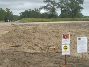
 Does Sabal Trail think black bears can’t walk the short distance from 24th Street, Stagecoach Road, and US 90 to 199th Place?
What about those fox squirrels and indigo snakes?
Gopher tortoises are also more places than people might think.
And what about that sinkhole only about 200 feet from the pipeline at Pilgrim’s Pride on US 90? These two pictures were taken from the same place, looking in opposite directions:
Here are the pictures, from north to south. I actually started on CR 132, but 24th Street is northernmost. I’ve grouped the pictures by the Sabal Trail maps from 7 April 2016, as made available online by Lowndes Area Knowledge Exchange (LAKE), in this order:
- 24th Street
- CR 132 aka Stagecoach Road
- CSX Railroad and Suwannee River State Park entrance
- US 90, Pilgrim’s Pride, sinkholes
- 199th Place, I-10, and the encampment
You’ve seen many of the encampment pictures before, but here are more, and they’re in context with nearby pipeline construction.
Maybe somebody would like to go back to these locations and send pictures of what they look like now. Please stay on public rights of way and strictly legal and peaceful.
24th Street

1657-PL-DG-70197-271, STA. 14157+00 TO STA. 14208+00, 14195+05 CL 24TH STREET, (SUWANNEE RIVER), SUWANNEE RIVER HDD – 1657-PL-DG-45109, HAMILTON & SUWANNEE COUNTIES, FLORIDA

Road Construction Ahead, 30.3979830, -83.1567670

n. to Gopher tortoise and blue pipe, 30.3993080, -83.1526930

n. to Gopher tortoise, black bear, and indigo snake signs, 30.3992800, -83.1525590

s. to signs and more pipe, 30.3991410, -83.1526820

Silt fence, 30.3991480, -83.1524670

WS Limits 14194+10 and beautyberry, 30.3991480, -83.1524500

24th St at 193rd Rd, 30.4004240, -83.1485650
CR 132 aka Stagecoach Road

1657-PL-DG-70197-272, STA. 14208+00 TO STA. 14261+00, 14243+66 CL WESTTOWER ROAD, SUWANNEE COUNTY, FLORIDA

Construction ahead, Stagecoach Road aka 132nd Rd, 30.3918858, -83.1480713

193rd Rd 30.3921870, -83.1486540

Be Prepared to Stop, 30.3992150, -83.1542120

n. to Sabal Trail cut through trees, 30.3919150, -83.1530010

s. to blue pipe beyond power line, 30.3914560, -83.1533650

Blue pipe along power line on West Tower Road, 30.3911860, -83.1529220

Signs and pipe, 30.3918 -83.152922

Indigo snake sign, 30.3918 -83.15293

Gopher tortoise sign, 30.3917 -83.15293

Black bear sign, 30.3917 -83.15291

Fox squirrel sign, 30.3918 -83.15291

Festive entrance to destruction, 30.3919480, -83.1534380

24th St, 30.3914570, -83.1570270
CSX Railroad

1657-PL-DG-70197-273, STA. 14261+00 TO STA. 14314+00, 14291+68 CL WESTTOWER ROAD, SUWANNEE COUNTY, FLORIDA

Blurry white Oklahoma truck that tailed me, 30.3863700, -83.1598060

Entrance, Suwannee River State Park, 30.3789410, -83.1658370

CSX RR, 30.3782040, -83.1659190

e. down CSX RR, 30.3779270, -83.1656780

n. up 201st Path across CSX RR, 30.3777510, -83.1658220

Suwannee River State Park to the left, 30.3773100, -83.1659620

Engine on CSX RR at US 90 side track, 30.3753350, -83.1605480
US 90, Pilgrim’s Pride, sinkholes

1657-PL-DG-70197-274, STA. 14314+00 TO STA. 14367+00, SUWANNEE COUNTY, FLORIDA

Be Prepared to Stop on US 90 at Pilgrims Pride, 30.3747630, -83.1601250

No Trespassing, silt fence, and pipe at Pilgrims Pride, 30.3726110, -83.1554560

Fiber Optic Cable marker beside Sabal Trail at Pilgrims Pride, 30.3721710, -83.1557370

e. to huge sinkhole just s. of US 90 e. of Pilgrims Pride, 30.3720440, -83.1548290

w. to Sabal Trail, less than 200 feet from sinkhole, 30.3721680, -83.1550210

Black truck and white truck tailing, 30.3763360, -83.1739660

Suwannee Plant, 4037 River Road, Duke Energy, 30.3770710, -83.1740020

Elite Construction Entrance to Duke Power Plant, 30.3753530, -83.1745780

Solar panel below power line at Duke Plant, 30.3667620, -83.1776470

Construction equipment in front of Duke Suwannee Plant, 30.3673830, -83.1780200

Power line, 30.3659250, -83.1774170

Buzzard on raccoon road kill, 30.3748550, -83.1747280
199th Place, I-10

1657-PL-DG-70197-275, STA. 14367+00 TO STA. 14420+00, 14 04+ 3 E I-10 F R OU, I-10 (EAST BOUND), I-10 (WEST BOUND), 14405+41 CL I-10 (EAST BOUND), 14404+44 CL I-10 (WEST BOUND), SUWANNEE COUNTY, FLORIDA

50th St @ River Road, 30.3592710, -83.1797470

50th St with black Texas truck tailing, 30.3591040, -83.1798000

199th Pl @ 50th St, 30.3590760, -83.1654590

Pipe on easement, 30.3553940, -83.1606090

Lots of pipe, 30.3554310, -83.1588280

Pipe in the weeds, 30.3551720, -83.1591940

Camp, 30.3537870, -83.1566400

Gregory Payne with AIM flag 30.3535843, -83.1567459

Camp with porta-potty on wheels, 30.3539030, -83.1566550

A peaceful encampment, 30.3533600, -83.1564640

New No Trespassing signs, but no endangered species signs, 30.3554060, -83.1568180

Price Gregory No Access, 30.3553510, -83.1567180

Peaceful demonstrators like Gregory Payne have permission from the landowner, 30.3552780, -83.1567150

Gregory Payne outside Sabal Trail No Trespassing zone, 30.3553680, -83.1567710

Oklahoma black truck driver talking to Texas black truck, 30.3553200, -83.1571020

jsq and Gregory Payne with Oklahoma white truck and Texas black truck, 30.3553850, -83.1569260

We Stand with Standing Rock: back of t-shirt, 30.3548000, -83.1567570

Vehicles on I-10 behind Sabal Trail mound of dirt, 30.3520240, -83.1591730

No Sabal Trail! No fracking Florida! You can not drink gas or oil, 30.3531800, -83.1565540
-jsq
You can join this fun and work by becoming a WWALS member today!
Short Link:

Since the Army Corps of Engineers permitted this, shouldn’t they be called about any violations?
Pingback: Crowdsourcing pictures of Sabal Trail path | WWALS Watershed Coalition