
Update 2016-11-07: You can put your own pictures on a related google map.
 From the air what you can’t see from the ground: Sabal Trail through north Florida and south Georgia.
Driving down I-10, you wouldn’t know Sabal Trail was digging underneath you,g for example.

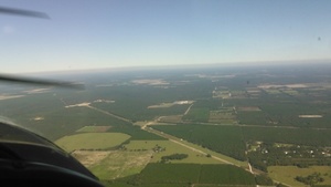
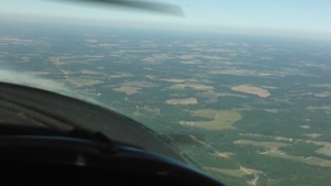
On Saturday October 22nd 2016, Southwings flew WWALS over more than 100 miles of the Sabal Trail route:
- Lake City pipe yard
- Santa Fe River
- Suwannee County, Florida
- Suwannee River
- Hamilton County, Florida
- Lowndes County, Georgia
- Withlacoochee River
- Okapilco Creek
- Brooks County, Georgia
- Colquitt County, Georgia
- Ocklockonee River
- Moultrie, Georgia
There will be later posts about much of what we saw.a
Meanwhile, here are pictures from two cameras for the entire route.
Click on any small picture for a bigger picture.
Or use the interactive Google Map, which has links to all these pictures and more, including digitization of much of the route by a student of VSU Prof. Can Denizman, and links to all of Sabal Trail’s April 2016 alignment maps for these counties.
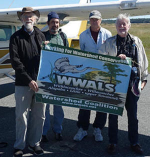
John S. Quarterman (WWALS), Dominick Gheesling, Roy Zimmer (Southwings), Jim Tatum (OSFR)
Thanks to Dominick Gheesling for taking many of these pictures in the air (the rest are by John S. Quarterman); thanks to Phil Hubbard for the camera and lens, thanks to Julie Bowland for producing, thanks to Jim Tatum of Our Santa Fe River for coming along, thanks to Roy Zimmer of Southwings for the flight, and thanks to Dave Moore of Southwings for patience.
More posts are listed in the WWALS Sabal Trail Issue web page, which also gives ways you can help stop this unnecessary, destructive, and hazardous fracked methane boondoggle.
-jsq
You can join this fun and work by becoming a WWALS member today!

Williams tanker truck carrying what? 30.4790878, -82.9835739

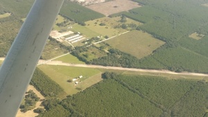
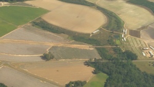
Liftoff, Airport, Lake City, FL, 30.1839638, -82.5790024
Lake City pipe yard

Lake City pipe yard, 30.2558270, -82.6399770

Lifting pipe off, 30.2558880, -82.6393410

Pipe in wetlands, 30.2556560, -82.6461460

RV Park, missing pipe, 30.2565530, -82.6368430

Across Rourkes Glen to pipe, 30.2524890, -82.6327400

nw to pipe yard, 30.2487220, -82.6369150

nw to pipe yard and wetlands, 30.2601150, -82.6456220
Santa Fe River
See US 129 HDD Santa Fe River Sabal Trail 2016-10-22.
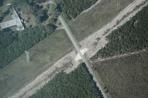
Suwannee County, Florida

W to concrete plant and quarry, 29.9787730, -82.8283360

Suwannee American Cement, 29.9615670, -82.8501280

N towards Live Oak across 182nd St & 89th Pl, 30.1071320, -82.9250120

NNE towards Wellborn across 182nd St & 89th PL, 30.1112480, -82.9310710

182nd St & 89th Pl, 30.1152820, -82.9335320

At road bend

Left bend, McAlpin Road (170th Terrace), 30.1403090, -82.9474120

9926 170th Terrace, McAlpin, FL 32062, 30.1361020, -82.9483580

NE to McAlpin Road (170th Terrace) dig, 30.1390840, -82.9448080

SW to Blue tractor at McAlpin Road (170th Terrace) dig, 30.1401380, -82.9436110

SW to McAlpin Road (170th Terrace) dig, 30.1399900, -82.9428300

SW to left bend NE of McAlpin, FL, 30.1466400, -82.9443530
Beside powerline road dig, 170th Terrace, 30.1389070, -82.9417020

SE from McAlpin down pipeline, 30.1423710, -82.9495140

US 129 (CR 249) curving away beyond pipeline and Croft Road, 30.1762580, -82.9970850

E across CR 252 & 117th Rd & US 129 (CR 249), 30.1761420, -82.9986100

15243 117th Rd, McAlpin, FL 32062 @ CR 252, 30.1733610, -82.9885370

12378 144th Terrace, Live Oak, FL 32060, 30.1866670, -83.0011340

129th Rd & 138th St, 30.1989090, -83.0140970

NE to apparent sinkholes NW of 129th Rd & 138th St, 30.2019830, -83.0166700

Path scraped between 133rd Path and 129th Rd, 30.2049290, -83.0244220

Smoking equipment at sinkhole between power lines, 30.2160250, -83.0315010

Jog around a pond, 30.2173320, -83.0368550

Jog around 145th Rd & 120th St, 30.2263840, -83.0433800

Backhoe smoking, 120th St at 145th Rd, 30.2312180, -83.0440170

Jog around 120th St @ 145th Rd. 30.2317640, -83.0470370

14341 120th St, Live Oak, FL, 30.2326820, -83.0449010

11689 145th Rd, Live Oak, FL 32060, 30.2357490, -83.0476850

11462 FL-51, Live Oak, FL 32060, 30.2404500, -83.0539290

155th Lane zig-zag, 30.2529670, -83.0689950

155th Loop, Live Oak, FL, 30.2565710, -83.0704100
15732 104th St, Live Oak, FL 32060, 30.2586240, -83.0735680

Right angle road dig context

Jog around 15961 District Line Rd, Live Oak, FL 32060, 30.2597510, -83.0758400

Crossing District Line Road, 30.2606030, -83.0743560

10016 161st Rd, Live Oak, FL 32060, 30.2654190, -83.0807880
16556 96th St, Live Oak, FL 32060, 30.2731320, -83.0908660

Piled dirt, pipe, avoiding 9228 Rocky Sink Rd, Live Oak, FL 32060, 30.2799380, -83.0979450

Some red pipe S of 92nd Terrace, 30.2816990, -83.0989500

Setting blue pipe in front of 9087 Rocky Sink Rd, Live Oak, FL 32060 @ 92nd Terrace, 30.2825450, -83.0998730

jog across power line from 9087 Rocky Sink Rd, Live Oak, FL 32060, 30.2830180, -83.0994120

Vehicles at NW end of pipe between 90th Terrace and 92nd Terrace, 30.2837890, -83.1013410

Digging at 90th Terrace, 30.2845810, -83.1014350

Digging under 90th Terrace, 30.2846400, -83.1021890

Blue pipe avoiding 17163 90th Terrace, Live Oak, FL 32060, 30.2853880, -83.1043780

Lots of houses within the blast radius @ 90th Terrace, 30.2857230, -83.1030020

Blue pipe in front of 17747 82nd Terrace, Live Oak, FL 32060, 30.2980880, -83.1175160

More blue pipe, 30.3031320, -83.1227820

Still more blue pipe, 30.3074490, -83.1262460

Jog right at Falmouth Road (185th Rd) & Mitchell Road (76th St), 30.3097440, -83.1375620

Jog around 7630 185th Rd, Live Oak, FL 32060, 30.3106680, -83.1296190

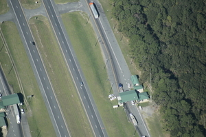
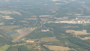
Duke Suwannee Power Plant in the distance, 30.3720380, -83.1790420
North across I-10 to Duke, Pilgrims Pride, 30.3099479, -83.1486588

About 300 feet in front of 19992 56th St, Live Oak, FL 32060, 30.3481600, -83.1612270

SW to porta-potty at 56th St s. of I-10, 30.3482630, -83.1616680

NW to blue pipe and portapotty at 56th St., 30.3468900, -83.1594550

Access to encampment, 30.3648643, -83.1722183

Access across easement, 30.3648643, -83.1722183

Agricultural inspection station, 30.3648643, -83.1722183
I-10 agricultural inspecion station, 30.3492400, -83.1537700

6 red pipe, many blue pipe @ I-10, 30.3516290, -83.1606840

6 red pipe & blue pipe at N I-10 dig, 30.3523590, -83.1603640

Across I-10 to original encampment, 30.3522190, -83.1591710
Digging under I-10 with traffic on it, 30.3512070, -83.1606820
Marked, I-10 n. digging area, 30.3524150, -83.1630950

E down I-10 with pipeline dig, 30.3525080, -83.1660570

Digging under I-10 and original encampment, 30.3595230, -83.1672480

Blue and red pipe @ 199th Pl & 197th Pl, 30.3556360, -83.1566820

3 red pipe at 199th Pl & 197th Pl, 30.3551000, -83.1572060

Easement now marked near encampment, 30.3554570, -83.1586340

SW to digging s. of I-10, 30.3493390, -83.1607470

Tanker truck and pipeline, 30.3514760, -83.1614180

NW to Digging under I-10 with traffic, 30.3487360, -83.1583790

I-10 to Pilgrims Pride, 30.3462581, -83.1437378

From I-10 across US 90, 30.3462581, -83.1437378

Pilgrims Pride, US 90, 30.3648380, -83.1636130

North to Pilgrims Pride, 30.3462581, -83.1437378

South to Pilgrims Pride, 30.3586216, -83.1596832

Pilgrims Pride driveway, US 90, CSX RR, Westtower Rd., 30.3732530, -83.1574100

Westtower Rd., 30.3760510, -83.1516190

Avoiding 3808 W Tower Rd, Live Oak, FL 32060, 30.3806760, -83.1515450

W to Westtower Rd., 30.3791550, -83.1464170

Blue pipe 600 feet in front of 3808 W Tower Rd, 30.3808940, -83.1486730

W to Westtower Road and CSX RR, 30.3763500, -83.1452960

6 red pipe, CSX RR, US 90, Pilgrims Pride parking lot, 30.3742200, -83.1537380
Suwannee River

Right angle to the west, 30.4143429, -83.1726227

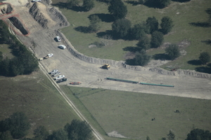
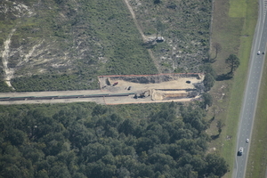
Drill pad in Suwannee County, 30.4066670, -83.1544220

Suwannee River HDD, 30.4073280, -83.1553070

Closeup with blue pipe, Suwannee River HDD, 30.4069760, -83.1547500

Context, Suwannee River, HDD, 30.4106310, -83.1606270

W across Suwannee River HDD, 30.4068450, -83.1500030

Digging equipment & portapotty, Suwannee River HDD, 30.4066500, -83.1515310

Suwannee River, HDD, Suwannee County, 30.4067330, -83.1539450

Under Suwannee River, 30.4078700, -83.1561750

Backhoe at Suwannee HDD, 30.4067690, -83.1544160

Likely preparation at Hamilton Co. HDD, Suwannee River, 30.4101550, -83.1666040
Hamilton County drill pad location between Withlacoochee and Suwannee Rivers, 30.4066190, -83.1700270
Hamilton County, Florida

NW 34th St & NW 36th Terrace, Jennings, FL 32053, 30.5321680, -83.2449810

1938 NW 36th Terrace, Jennings, FL 32053, 30.5334150, -83.2487460

Island in Withlacoochee River w. of NW 25th Street, 30.5633330, -83.2633090

Island closeup w. of NW 25th Street, 30.5627660, -83.2564640
Lowndes County, Georgia

N across Withlacoochee River and G-FL line Clyattville and PCA (l.), Valdosta (top), Grassy Pond and Lake Park (r.), 30.6171880, -83.2790230

Horn Bridge, Mozell Spells, Withlacoochee River, GA-FL line, 30.6353490, -83.3115710

Clyattville and PCA, 30.6734720, -83.3245120
Clyattville and PCA again, 30.6977490, -83.3144000
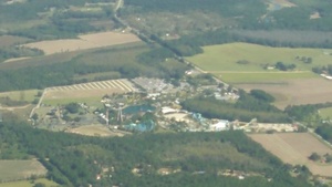
Wild Adventures, 30.7196194, -83.3247917

Wild Adventures back lot, 30.7181160, -83.3255790

Wild Adventures entrance, 30.7215910, -83.3186420

Unused Sabal Trail contractor yard, front of Martins Famous Pastries, across Old Clyattville Rd from Valdosta Airport, 30.7882360, -83.2850740
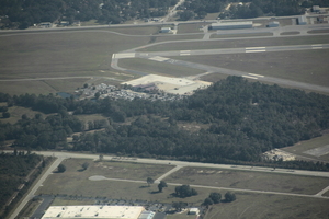
Contractor yard, Valdosta Airport, 30.7879760, -83.2768660

Unused contractor yard w. of I-75, 30.7857900, -83.3016270
pipeline crosses lower left in picture; Langdale Pond and Kinderlou-Clyattville Road, 30.7507770, -83.3582090

5212 Lanes Pond Rd, Valdosta, GA 31601, 30.7201350, -83.3673860

4471 Rocky Ford Road, 30.7328980, -83.3836320
Withlacoochee River
See also What is that yellow thing in the Withlacoochee River, Sabal Trail, at HDD US 84 between Quitman and Valdosta, GA?

North to Langboard and US 84, 30.7145786, -83.4042740

HDD, Brooks County, Withlacoochee River, 30.7969680, -83.4550060

KIMG7618 30.7392731, -83.4548416

HDD, Lowndes County, Withlacoochee River, 30.7878510, -83.4461450

Withlacoochee River HDD, 30.7955040, -83.4522530

Carter Way, Martin Lane, HDD, 30.7909020, -83.4439540

Tiger Creek, Martin Lane, HDD, 30.7887580, -83.4447700

Equipment, HDD, Lowndes County, 30.7875500, -83.4459950

Spook Bridge, 30.7898280, -83.4516900

CSX RR Bridge, 30.7928690, -83.4534060

What is in Withlacoochee River at pipeline crossing? 30.7948360, -83.4529480

Langboard, 30.7867130, -83.4800150

Quitman, GA 31643, 30.7849220, -83.5581610
Okapilco Creek

Okapilco Creek, Coffee Road, 30.9182630, -83.5925410

Closeup, Okapilco Creek, Coffee Road, 30.9192720, -83.5954390

Borrow pit? Kennedy Hill Rd, 30.9196560, -83.6027510

Pipeline clearing heading n. of Coffee Rd., 30.9226010, -83.5982740
Brooks County, Georgia

Tallokas Road, 30.9818670, -83.6497250

Sandhill Grocery, 30.9847460, -83.6605846

GA 122 @ Tallokas Rd, 30.9838830, -83.6543860
E to Gardner Rd & Lawrence Rd, 31.0168540, -83.6880580
Colquitt County, Georgia

NE across chicken houses and Crum Rd to Tallokas Rd., 31.0457850, -83.7178090

Emerald Hill Church and 226 Crum Rd, Moultrie, GA 31788, 31.0545390, -83.7091640

NE to burning NW or Crum Rd, 31.0484240, -83.7222160

Burning s. of Hog Creek and Crosby Road, 31.0568290, -83.7144840

Tributary of Hog Creek, Plymel Road and Jog around 169 Beverly Ln 31.0708900, -83.7317520

954 J D Herndon Rd, Moultrie, GA 31788, 31.0869580, -83.7505590

Back south to the burn, 31.0887410, -83.7468890

N across 853 Plymel Rd to Goodson Rd., 31.0699950, -83.7415250

W. to 5088 Tallokas Rd, 31.0755440, -83.7338600

S. across Tallokas and Crosby Rd., 31.0614730, -83.7186290

N up Okapilco Creek to Moultrie, GA 31.0801480, -83.7704620

N across Gene McQueen Rd to Moultrie, 31.0998070, -83.7817610

Jog around Stones Home Center, 139 U.S. 319, Moultrie, GA 31768, 31.1130500, -83.7857840

Ice House America, near Twin Lakes Drive and Tanglewood Ct., 31.1122970, -83.7893190

Around Silverwood Ct., 31.1156870, -83.7917940
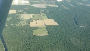
NW from Moultrie into the horizon, 31.1222710, -83.8073520
Ocklockonee River

N over Sauls Rd Contractor Yard to Midway Free Will Baptist Church on Ochlockonee River, 31.1323620, -83.8159200
Moultrie, Georgia

SSE across 4399 GA-37, Moultrie, GA 31768 across Little Creek and Kendalwood Church Road, 31.1923770, -83.8941040

Hampton Inn, 441 Hampton Way, Moultrie, GA 31768, 31.1884510, -83.7630670

Contractor Yard CY3-6 full of equipment, E down County Farm Road NE to Industrial Blvd., 31.1836510, -83.7523580
Google Map
Follow this link to the google map, or use the copy embedded below.
You can join this fun and work by becoming a WWALS member today!
You can join this fun and work by becoming a WWALS member today!
Short Link:
Pingback: Sabal Trail maps digitized | WWALS Watershed Coalition
Pingback: Crowdsourcing pictures of Sabal Trail path | WWALS Watershed Coalition
Pingback: Sacred Water Camp protecting the Suwannee River from Sabal Trail 2016-11-06 | WWALS Watershed Coalition
Pingback: Water Is Life Camp protecting Santa Fe River against Sabal Trail | WWALS Watershed Coalition