Don’t spill, Valdosta. Don’t leak, Sabal Trail. Hurricane Irma is bad enough already.
Valdosta announced its WWTP would be “manned around the clock”, so I called down there before 8AM this Saturday morning, and somebody did answer immediately. I told him as Suwannee Riverkeeper I was concerned for people downstream who don’t want any spills during the upcoming rains, so I was glad to see it was true they were there. I asked him if they had backup generators. He said yes. Of course, that doesn’t handle every manhole cover. We shall see. Don’t spill, Valdosta! (Or Lowndes County, or Tifton, or anybody else.)

Currently expecting somewhere between 4 and 10 inches of rain on Valdosta.
Map from National Hurricane Center, 2017-09-09 8AM.
City of Valdosta, PR, 8 September 2017, Valdosta-Lowndes County Hurricane Irma Update,
- The Valdosta Water Plant and Wastewater Treatment Plants will be manned around the clock and all have alternative power supplies. Generators are on hand to connect to any lift stations in the event of power loss.
Hurricane Irma’s projected path has shifted west of Valdosta.
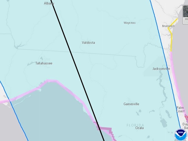
Map from National Hurricane Center, 2017-09-09 8AM.
But Hurricane Irma going up the west coast of Florida actually means more rain inland, as the strongest winds are northeast of the eye, and the warm Gulf waters keep it stronger longer.

Source: National Hurricane Center.
This is what I-75 looked like last night at Exit 29 past Hahira, Georgia:

Screenshot passed around on facebook of unknown TV station, possibly WCTV, 8 September 2017.
Can attest that that really is what I-75 looked like.
Suwannee River watershed
In the seven downstream Florida counties that passed resolutions against Valdosta’s wastewater spills, here are a few news updates. This is by no means an exhaustive survey; please check with your local county emergency management (see links at the end) for current updates.
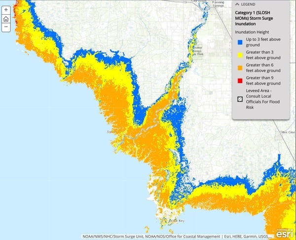
Category 1 Storm Surge, Suwannee River,
NOAA Storm Surge Interactive Map Viewer.
Levy County
I don’t know whether Cedar Key ever got these FEMA funds after Hurricane Hermine, but now the island is in the path of Hurricane Irma. WUFT News, WUFT, 6 June 2017, Cedar Key Still Waiting For FEMA Funds As Hurricane Season Arrives.
As Cedar Key FL Pirate Invasion Weekend posted on facebook yesterday,
Welcome to the Good Ship “Deja Vu”…
Tho the storm be fierce and the days long, we are watching, waiting, and hopeful.
BUT—we are PIRATES and if at all possible, we will hold a helluva party after Irma!..
Williston Pioneer, 8 September 2017, MANDATORY EVACUATION FOR LEVY COUNTY
MANDATORY EVACUATION has been ordered for Levy County residents beginning at 4 p.m. today, September 8, 2017.
Shelters in Levy County including the special needs shelter, will be opening at 4 P.M. today, September 8th. The first shelter location opening is the Bronson Elementary School, this is our only special needs location, but will also house general population. Overflow from this shelter will be moved to the Bronson Middle/High School, today if needed. The Williston Middle/High School will be the third facility to open for citizens seeking shelter on Saturday 9/9/17 at 9 a.m. Overflow from the Williston Middle/High will be moved to the Williston Elementary School, as needed.
Citizens seeking shelter at any of the listed general population shelters will need to bring pillows, blankets, medications and bedding. Cots for sheltering citizens will not be available.
Dixie County
Dixie County Emergency Management, 8 September 2017, UPDATE ADVISORY!!!!
As of 7pm tonight, September 8th 2017, with the anticipation of Hurricane Warnings and Watches for Dixie County, Dixie County has now issued a MANDATORY evacuation order for ALL of DIXIE COUNTY residents!!!
The evacuation order is based on the latest Weather Service Advisory indicating that Dixie County is expected to receive tropical storm force winds beginning Sunday morning, September 10th, increasing to Category 2 Hurricane Force Winds extending for an estimated 30+ hours.
Storm surge predictions are currently 3-6 foot above ground.
Citizens should be advised that any changes in the storm’s track may increase impact.
Shelters will be open on Saturday, September 9, 2017 at 10:00am…
Gilchrist County
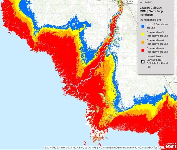
Category 2 Storm Surge, Suwannee River,
NOAA Storm Surge Interactive Map Viewer.
Gilchrist County Emergency Operations Center, 8 September 2017, MEDIA RELEASE: Hurricane Irma # 1,
The current forecasted track of Hurricane Irma indicates that it will directly impact Gilchrist County. Residents are strongly urged to make necessary preparations to protect property and personal safety. The storm is expected to bring 6-8 inches of rain and sustained winds of 70-95 miles per hour. In addition, there is a strong potential of tornadoes as the storm approaches and passes through the area. The period of strongest winds are expected between 12:00 PM Sunday September 10, 2017 and extending through Monday September 11, 2017.
Sandbags available at the following locations:
Lafayette County
Suwannee Democrat, 6 September 2017, State of emergency may be declared Friday in Lafayette County.
Lafayette County Sheriff’s Office, facebook, 8 September 2017, Emergency Shelter,
Be advised that a General Population Shelter will open at the Lafayette County High School Cafeteria at 8:00 am Sunday September 10th. Suggested items to bring to the shelter are bedding, pillow, extra clothing, medications, non perishable food, small flashlight, and children’s needs if applicable. Things not to bring and are prohibited include alcoholic beverages, illegal drugs, and weapons. Due to large number of evacuees coming through our county, if you plan on using the shelter it is recommended to come early.
Suwannee County
Suwannee Democrat, 8 September 2017, Suwannee County adds fourth shelter, adjusts opening times.
Madison County
Madison County Emergency Management, facebook, 8 September 2017 3PM, Hurricane Irma Storm Update
Hurricane Irma remains a very large and powerful storm. While the storm is forecasted to turn a little more to the west, County staff are communicating constantly with state officials and closely watching the storm’s track. Small changes in the storm’s direction can make a big difference in our protective actions.
Tropical storm force winds will be felt well away from the center of the storm and are expected in our area early Sunday morning and will last throughout the day into Monday. Main impacts to our area include wind damage and power outages. Those power outages may be longer and more widespread than what was experienced with Hurricane Hermine….
Hamilton County
Hamilton County Sheriff’s Office Division of Emergency Management, facebook, 9 September 2017 8AM, Shelter open,
Hamilton County Emergency Management has opened a General Population shelter at the (new) Hamilton County High School Gym. The High School is located at 5683 US Hwy 129 S Jasper, FL. Please bring with you any personal items such as medications, pillows, covers that you may need.
Columbia County
It’s not one of the downstream seven, but Columbia County is also directly on the Suwannee River. Columbia County Emergency Management, 8 September 2017 7:15PM, Hurricane Irma – Columbia County: Volunteers Needed and Shelter Openings
Hurricane Irma’s path shifted west this afternoon. Irma is expected to be a Category 1 or slightly greater hurricane once it arrives in North Florida. Currently the eye of the storm is projected to pass to the west of Columbia County Monday. Tropical Storm winds are anticipated to arrive in Columbia County area Sunday Evening between 5:00 p.m. and 7:00 p.m. Maximum forecasted sustained winds of 75 mph with gusts 20 to 30 mph higher are expected at the peak of the storm. The greatest impact will take place between 8 am—4 pm Monday. Rain fall in Columbia County is estimated to be between 6-10+ inches during the storm.
We strongly urge Columbia County residents to stay posted for updates and ensure you are prepared. Important topic updates listed below….
Withlacoochee (south) River watershed
WWALS has members in the watershed of the south Withlacoochee River that flows directly into the Gulf.
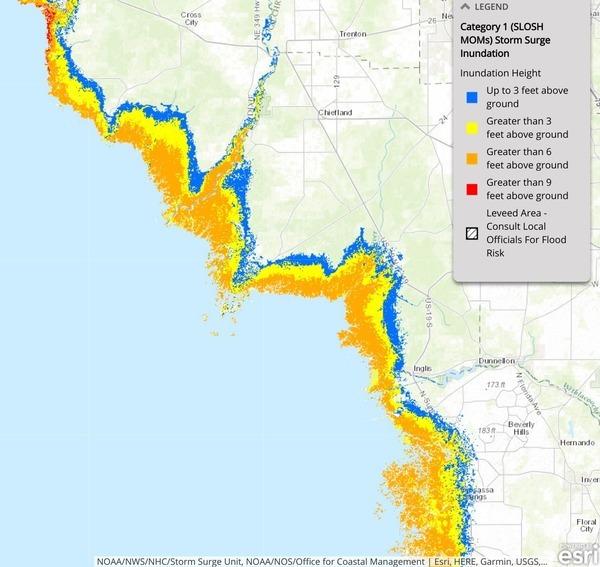
Category 1 Storm Surge,
NOAA Storm Surge Interactive Map Viewer.
Citrus County
Citrus County is home of nuclear waste still at the closed Crystal River plant, plus the building natural gas plant and Strom Inc.’s approved LNG export location next door, all within major hurricane flood zones. Mike Wright, Citrus County Chronicle, Irma aims at Citrus: Just how close the hurricane comes to the county is still a big unknown,
At its track Friday afternoon, Irma’s eye appeared headed for the Citrus-Sumter county line, [Capt. David] DeCarlo [director of the Emergency Operations Center] said. Any movement west would bring it directly through Citrus County as a Category 2 or strong Category 1 hurricane, he said.
Potentially worse, he said, is if the storm strays even further west skirting the coast, similar to Hurricane Hermine a year ago. Such an event would bring unprecedented flooding, he said.
“A direct hit could be up to 15 foot,” DeCarlo said. “We’ll know more as the storm gets closer.”
As of 5 p.m. Friday, Citrus County was part of a hurricane watch that extended from Anna Maria Island to the Suwannee River, according to the National Hurricane Center.
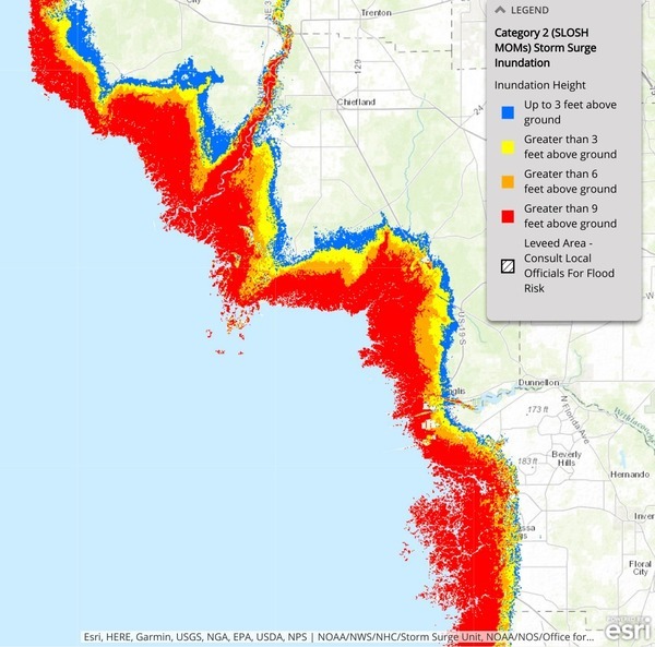
Category 2 Storm Surge,
NOAA Storm Surge Interactive Map Viewer.
Marion County
In Marion County, Florida, host to Sabal Fail’s Dunnellon Compressor Station site with its leaky Mercaptan stink tanks: Susan Smiley-Height, Ocala Star-Banner, 8 September 2017, Marion’s mobile home residents ordered to evacuate.
Don’t leak, Sabal Trail!
All Florida
Florida Division of Emergency Management, Florida County Emergency Management Web Sites.
-jsq, John S. Quarterman, Suwannee RIVERKEEPER®
You can join this fun and work by becoming a WWALS member today!
Short Link:
