
Thanks to Jay Bushnell for the heads-up on this FDEP notice of February 6, 2018:
Impaired Waters Rule (IWR) Notification
The department announces the availability of the 2018 Strategic Monitoring Plans. These plans represent the water quality and biological monitoring needs identified by the department in preparation for basin assessments as part of the watershed management approach.

The Watershed Assessment Section developed the 2018 strategic monitoring plans available here to assist in assessing the health of Florida’s surface waters by conducting biological assessments and water quality sampling. These activities are carried out by seven Regional Operation Center (ROCs) located throughout the department’s six District offices and by staff in Tallahassee. This extensive monitoring effort is accomplished through coordination with water management districts, city and county governments.
The data collected from these efforts is used to evaluate Florida’s surface waters through the application of the Impaired Waters Rule (Chapter 62-303, Florida Administrative Code) assessment methodology. These monitoring efforts focus on collecting data where there may be shortfalls. These data are combined with other data available to the department by many other data providers and will be uploaded to the Watershed Information Network (WIN), formerly Florida STORET.
Monitoring data collected is used to assess the waterbody health and for those waterbodies that are verified as impaired, provides data used to develop Total Maximum Daily Loads (TMDLs) and evaluate implementation of Basin Management Action Plans (BMAPs).
For additional information on the development of the strategic monitoring plans or on the watershed management approach, please contact Kevin O’Donnell by phone at: 850-245-8469 or by email.
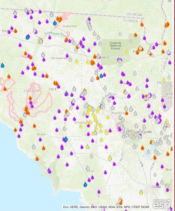
For additional information on water quality and biological monitoring site locations, please visit the Water Quality Monitoring Activity Tracker (MAT). The MAT is an interactive web-map application showing the locations where the Division of Environmental Assessment and Restoration staff conducts water quality and biological monitoring.
That FDEP MAT map looks like widespread coverage, until you zoom in.
All-sampled-2015-2017, Sampled
Still, it looks like a lot of sampling, until you narrow the time frame.
Not much planned in the next seven days. And there seems to have been a severe drop-off in sampling in 2017.

Next-seven-days, Sampled

Sampled-2015, Sampled

Sampled-2016, Sampled

Sampled-2017, Sampled
Perhaps some gaps need to be filled in.
-jsq, John S. Quarterman, Suwannee RIVERKEEPER®
You can join this fun and work by becoming a WWALS member today!
Short Link: