
Approved at the Sunday WWALS board meeting and filed last night via regulations.gov as PDF.
April 15, 2019
U.S. Environmental Protection Agency
EPA Docket Center
Office of Water Docket
Mail Code 28221T
1200 Pennsylvania Avenue, NW
Washington, DC 20460
Re: Docket ID No. EPA-HQ-OW-2018-0149,
Revised Definition of Waters of United States
To Whom it May Concern:
WWALS Watershed Coalition, Inc. (WWALS), also known as Suwannee Riverkeeper, submits the following comments on the United States Environmental Protection Agency (“EPA”) and Department of Defense, Department of the Army, Corps of Engineers (“Corps”) proposed rule entitled “Revised Definition of Waters of United States,” 84 Federal Register 4154-01 (February 14, 2019) (hereinafter “Proposed Rule”).
In addition to supporting the comments of Waterkeeper Alliance and the Southern Environmental Law Center (SELC), WWALS adds these comments on groundwater.
The Proposed Rule’s categorical exclusion of groundwater makes no sense here above the Floridan Aquifer where surface water and groundwater constantly interchange, and pollutants travelling through groundwater are a frequent source of health, environmental, and economic problems.
![[2019-04-15--WWALS-to-EPA-0001]](https://www.wwals.net/pictures/2019-04-15--epa-rule-deadline/2019-04-15--WWALS-to-EPA-0001.jpg)
This proposed exclusion of groundwater is called out repeatedly in the Proposed Rule, starting with this:
Section II. Background A. Executive Summary, fourth paragraph:
The proposal would exclude from the definition of “waters of the United States” waters or water features not mentioned above. The proposed definition specifically clarifies that “waters of the United States” do not include features that flow only in response to precipitation; groundwater, including groundwater drained through subsurface drainage systems; ….
Just because a feature only flows in response to precipitation is no reason to believe it cannot carry pollution. Features such as extended floodplains can carry pollution into groundwater. Much of the fragile, fractured, limestone rock containing the Floridan Aquifer is a natural subsurface drainage system, refilling that Aquifer, which is the main water source for drinking, industry, and agriculture in south Georgia and most of Florida.
This is not just some theoretical matter. Withlacoochee River water going into Shadrick Sink west of the river, then under the river and miles east, forced the city of Valdosta to sink its water wells twice as deep, as documented by the USGS in 1999. See Appendix A.
This is not just an issue for Valdosta, or Lowndes County, or Georgia. Florida has even more sinkholes and springs than south Georgia, and underground water also moves sideways all over the Floridan Aquifer, as has been known since at least the 1980s. See Appendix B.
More recent USGS research also finds salt water moving in layers among the fresh water, including the “Apalachicola salinity feature” all the way from the Gulf of Mexico to Lowndes County, Georgia, with a special additional “brackish Valdosta feature”; see Appendix C.
If natural river water and sea salt can move underground for many miles, there is no reason to expect that sewage or chicken manure or coal ash or pipeline leakage or drilling fluids or fracking waste could not do the same.
The section on the Proposed Definition has a discussion on what would be excluded, in III.H.
III.H.1. paragraph 1:
In paragraph (b) of the proposal, the agencies propose eleven exclusions from the definition of “waters of the United States.” Specifically, under this proposal, any water not enumerated in paragraphs (a)(1) through (6) would not be a water of the United States. The proposed rule would exclude groundwater, including groundwater drained through subsurface drainage systems. This proposed rule would exclude ephemeral surface features and diffuse stormwater run-off such as directional sheet flow over upland.
The main change to U.S. statutes would be this additional exclusion from Waters of the United States, as 33 CFR 328.3(b)(2):
Groundwater, including groundwater drained through subsurface drainage systems;
Yet directional sheet flow over upland can, for example, overflow a wastewater treatment system, such as happened with Valdosta, Georgia’s, old (now-closed) Withlacoochee Wastewater Treatment Plant (WWTP) in 2009 and 2013, sending untreated sewage into the Withlacoochee River; see Appendix D. Then and in more recent years, owners of wells near that same river find E. coli in their well water that may be timed with sewage or other contaminants coming downstream.
The agencies seem to realize the Proposed Rule lacks clarity regarding groundwater, when they ask:
III.H.4. …seeking comment, second paragraph:
Further, the agencies seek comment on the clarity of the groundwater exclusion in proposed paragraph (b)(2) and ask commenters to consider whether the exclusion could instead read, “groundwater, including diffuse or shallow subsurface flow and groundwater drained through subsurface drainage systems.” The agencies recognize that unique groundwater situations such as shallow aquifers and tile drainage systems exist around the country and welcome comments on the parameters of the groundwater exclusion and any implementation issues that may arise.
The agencies and the Proposed Rule do not seem to recognize widespread groundwater situations such as the Floridan Aquifer, which underlies most of Florida, south Georgia, and parts of South Carolina and Alabama, with natural drainage systems into and out of levels of the aquifer from shallow to deep.
The agencies should not exclude groundwater. Instead, they should clarify how discharges to surface waters through groundwater are not exempt. They should also clarify how contamination of groundwater through surface waters is not exempt.
Further, EPA and the other agencies should do what Sierra Club proposed three years ago. They should declare the Floridan Aquifer a Sole Source Aquifer (SSA) with extra protections.[1] As that 1999 USGS report says (see Appendix A), the Floridan Aquifer “is the sole source of water supply for Valdosta, Georgia, and much of the surrounding area.” The surrounding area which uses groundwater as its sole source of water supply, for drinking, industry, and agriculture, most if not all of the Suwannee River Basin in Georgia and Florida, and much if not all of the Floridan Aquifer.
Thank you for the opportunity to submit these comments.
John S. Quarterman,
Suwannee RIVERKEEPER®
229-242-0102
contact@suwanneeriverkeeper.org
WWALS Watershed Coalition, Inc.
850-290-2350
wwalswatershed@gmail.com
www.wwals.net
PO Box 88, Hahira, GA 31632
Appendix A: Sinkhole groundwater into Valdosta well water
In Sustainability of Ground-water Resources, by William M. Alley Thomas E. Reilly O. Lehn Franke, 1 January 1999, U.S. Department of the Interior, U.S. Geological Survey – Publisher, http://pubs.usgs.gov/circ/circ1186/. In Box E on Page 63, The Connection Between Surface-Water Quality and Ground-Water Quality in a Karst Aquifer
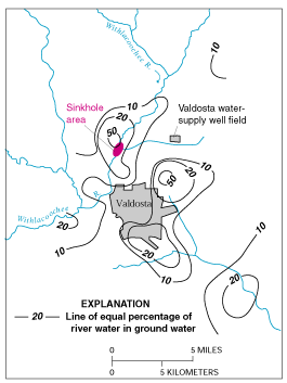
Figure E-1. Estimated percentage of Withlacoochee River water in ground water in the Upper Floridan aquifer, June 1991. (Modified from Plummer and others, 1998.)
The Upper Floridan aquifer, which is the sole source of water supply for Valdosta, Georgia, and much of the surrounding area, receives large volumes of direct discharge from the Withlacoochee River through sinkholes in the streambed or off-channel. A highly interconnected conduit system has developed in the Upper Floridan aquifer in this area, which extends at least 15 miles from the sinkhole area. Chloride and isotopic data were used by Plummer and others (1998) to map the percentage of Withlacoochee River water in ground water in the Upper Floridan aquifer (Figure E-1). These data indicate that ground water in parts of the Upper Floridan aquifer contains high percentages of recently recharged Withlacoochee River water. Plummer and others (1998) note that, although the patterns shown in Figure E-1 are generally true over the area, extreme variations can occur at a given location, as would be expected because of the large variations and discontinuities in hydraulic properties in the karst environment and time-varying inflows of river water into the aquifer.
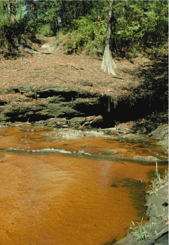
Sinkhole near the Withlacoochee River. (Photograph by Richard E. Krause, U.S. Geological Survey.)
The strong connection between the Withlacoochee River and ground water in the Valdosta area has created concerns about the potential for contamination of ground-water supplies by contaminants in the river. There also are concerns about the effects of natural organic matter in the river water. For example, in the early 1980’s, it was recognized that chlorination of aquifer water produced disinfection by-products in excess of drinking-water standards. This occurred as a result of reaction of chlorine with the high amounts of natural organic matter in the river water recharged to the aquifer.
Appendix B, Groundwater movement in the Floridan Aquifer.
In GROUND WATER ATLAS of the UNITED STATES: Alabama, Florida, Georgia, and South Carolina, HA 730-G, Floridan aquifer system, http://pubs.usgs.gov/ha/ha730/ch_g/G-Floridan6.html
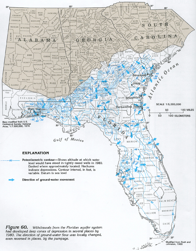
Figure 60 Map showing potentiometric contours and ground-water movement in the Floridan aquifer system in 1980 (608K),
Appendix C: Salt Water Intrusion
In Revised Hydrogeologic Framework of the Floridan Aquifer System in Florida and Parts of Georgia, Alabama, and South Carolina, By Lester J. Williams and Eve L. Kuniansky, Professional Paper 1807, First release: April 2015, Revised March 2016 (ver. 1.1), Groundwater Resources Program, U.S. Department of the Interior, U.S. Geological Survey, Reston, Virginia: 2015, https://pubs.usgs.gov/pp/1807/pdf/pp1807.pdf
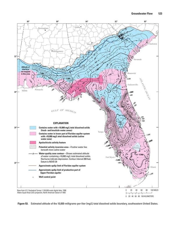
Figure 53. Estimated altitude of the 10,000-milligrams-per-liter (mg/L) total dissolved solids boundary, southeastern United States.
Appendix D: Withlacoochee Wastewater Treatment Plant overflows in 2009 and 2013
https://www.wctv.tv/home/headlines/Valdosta-Wastewater-Plant-Operational-Again-193059631.html
City of Valdosta Press Release,
March 3, 2013
Withlacoochee Wastewater Treatment Plant Fully Operational
At approximately 1:30 p.m. today, March 3, the Withlacoochee Wastewater Treatment Plant was brought online and returned to normal operation, after a loss of function for only three days compared to the nine days of complete loss of function experienced in the flood of 2009.
Today, the river receded to the point where the temporary by-pass pumps could be connected to the existing valves. The system was turned on, became fully operational and began full treatment capabilities.
Lessons learned from the 2009 flood resulted in proactive measures which include the following:
The installation of bypass pumps, pipes and valves to utilize in the event of an emergency or act of God.
In 2009, the berm only protected the pump station, which did not prevent flooding of the chemical building, the chlorine contact building, the filters and the belt presses. The plant’s electrical system was destroyed in the flooded area and the filters and belt presses were inoperable.
wwalswatershed@gmail.com PO Box 88, Hahira, GA 31632 Page of 850-290-2350 www.wwals.net
[1] “More Floridan Aquifer Protection Called for by Sierra Club Petition to EPA,” Press Release, Sierra Club, 5 May 2015, http://www.sierraclubfloridanews.org/2015/05/more-floridan-aquifer-protection-called.html
-jsq, John S. Quarterman, Suwannee RIVERKEEPER®
You can join this fun and work by becoming a WWALS member today!
Short Link: