
The Upper Suwannee River is new to the
WWALS Mission.
 WWALS Watershed Coalition, a WATERKEEPER® Affiliate,
applied in July to WATERKEEPER® Alliance to add that new
territory, which was approved 15 July 2015.
WWALS Watershed Coalition, a WATERKEEPER® Affiliate,
applied in July to WATERKEEPER® Alliance to add that new
territory, which was approved 15 July 2015.
Three years ago when WWALS was forming, we decided not to include the Upper Suwannee at that time, because we wanted time to solidify WWALS as an organization in its smaller territory of the watersheds of the Withlacoochee and Alapaha Rivers and all their tributaries. Even then, we put the S in WWALS so it could be redefined to mean Suwannee, so our acronym would expand to Withlacoochee, Willacoochee, Alapaha, Little, and Suwannee River watersheds.
WWALS now asks Waterkeeper to add Upper Suwannee HUC 03110201 to WWALS territory.
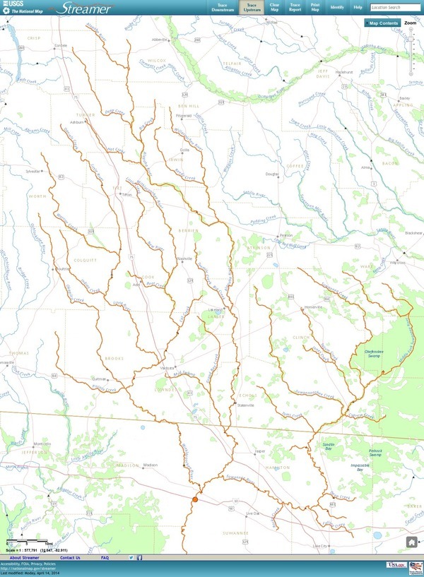
HUC is United States Geological Survey (USGS) jargon for Hydrologic Unit Code. Upper Suwannee HUC 03110201 is everything from the Withlacoochee Confluence upstream that drains into the Suwannee River. This 2720 square miles:
…add in Georgia the rest of Echols County, a sliver of Brantley, parts of Ware (with Homerville), Baker, and Charlton Counties, and most of Clinch County (with Fargo). In Florida it will add the rest of Hamilton County (with Jasper plus White Springs), parts of Suwannee and Columbia (with Watertown and part of Lake City), and a sliver of Baker County.
Among waterways, the Upper Suwannee HUC includes the Black River that runs into the west half of the Okefenokee Swamp, and all the creeks that cross US 84 from there west: Big Alligator Creek, Little Alligator Creek, Greasy Branch, Suwannee Creek, Little Suwannee Creek, Box Creek in Argyll, Peters Branch, Cane Creek, Woodyard Creek in Homerville, and Suwannoochee Creek at DuPont. Also in Georgia, Tatum Creek, Toms Creek, and Cypress Creek. In Florida, Deep Creek, Falling Creek, Rocky Creek, Pinhook Swamp, and doubtless many other creeks, swamps, and bays in both states.
 Total WWALS territory then adds up to 6,954 square miles.
The original WWALS territory of 4,232 square miles includes the watersheds of the Withlacoochee, Little, Alapaha, and Willacoochee Rivers, in all or parts of 22 counties, as well as all the biggest population centers in the entire Suwannee River Basin: Valdosta in Lowndes County, Tifton in Tift County, and Moultrie in Colquitt County, all in Georgia.
Why add this Upper Suwannee territory now? Numerous reasons, including:
WWALS has active participants in the Upper Suwannee HUC. One of the judges for the Alapaha River Water Trail (ARWT) logo contest lives in White Springs, Florida. Jasper Hardware donated a prize to that contest. The Hamilton County, FL Tourist Development Council that contributed funds for the ARWT is headquartered in Jasper. Two of the most active outfitters for the Alapaha and Withlacoochee are actually on the Suwannee River in the Upper Suwannee HUC (one in Hamilton County and one in Suwannee County). Columbia County, FL has also shown quite a bit of interest in the ARWT. We also have a member in Dupont, Ware County, Georgia.
WWALS co-signed with others a letter by Southern Environmental Law Center on behalf of Satilla Riverkeeper asking the Georgia Department of Transportation and the U.S. Army Corps of Engineers for more information and a hearing about a proposed widening of US 84 between Waycross (in Satilla River territory) and Homerville (in the Upper Suwannee HUC).
 That US 84 widening project continues with
thirty-day GA-EPD comment periods
on two wetland items, one of which is
at Greasy Branch east of Manor.
That US 84 widening project continues with
thirty-day GA-EPD comment periods
on two wetland items, one of which is
at Greasy Branch east of Manor.
WWALS was supported in adding the Upper Suwannee River territory by its neighboring Riverkeepers: Flint to the west, and Satilla to the east. One of them had advocated this move more than three years ago, and now that WWALS is well-established, the time has arrived.
As always, WWALS continues to communicate and cooperate with all its neighbors in all directions, including Save Our Suwannee (SOS) and Gulf Restoration Network downstream, and Our Santa Fe River (OSFR) representing the other big tributary of the Suwannee, with the Itchetucknee Alliance representing OSFR’s own main tributary, as well as the Ocholockonee River Water Trail to the west and many others.
-jsq
You can join this fun and work by becoming a WWALS member today!
Short Link:
Pingback: Outings, Upper Suwannee, Water Trails, Water Council, and against Fracking and Sabal Trail pipeline -August 2015 WWALS Newsletter - WWALS Watershed Coalition