
Even the trend of sinking groundwater levels hasn’t changed a lot in the Georgia
parts of WWALS’ watersheds of the Withlacoochee, Alapaha, and upper Suwannee Rivers.
 Thanks to Tom Potter for the pointer, and we’re inviting someone to talk about this subject at the
Withlacoochee and Little River Water Trail Workshop at VSU February 27th, 2016.
Thanks to Tom Potter for the pointer, and we’re inviting someone to talk about this subject at the
Withlacoochee and Little River Water Trail Workshop at VSU February 27th, 2016.
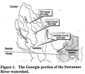
WATER RESOURCES OF THE UPPER SUWANNEE RIVER WATERSHED, by Mary M. Davis1 and David W. Hicks2,
1 Ecologist,
National Wildlife Federation, 1330 West Peachtree Street, Suite 475. Atlanta, GA 30309.
2Adjunct Scientist. Joseph W.
Jones Ecological Research Center at Ichauway, Newton, GA
Proceedings of the 2001 Georgia Water Resources Conference, held March 26-27, 2001, at the University of Georgia. Kathryn
J. Hatcher. Editor. Institute of Ecology, The University of Georgia, Athens, Georgia.
Abstract. Situated in rural, south-central Georgia, the Alapaha, Little, Withlacoochee, and Suwannee Rivers of the Suwannee River watershed are important resources for the economy and health of the region. Groundwater is also an important resource in the region, as the Upper Floridan aquifer provides water for domestic, agricultural, and industrial supply. Declining water levels in the Upper Floridan aquifer in the northern part of the watershed, however, are indicative of overuse. Hydrologic monitoring is sparse in the watershed and studies conducted in other parts of the state, such as in the Flint River watershed, do not necessarily provide data or interpretations that are applicable to the Suwannee River watershed. Studies are necessary, therefore, to understand interactions between surface water and groundwater in this watershed and to develop effective regional water-management strategies.
A 2003 USGS publication shows some slight recovery of groundwater if Cook County.
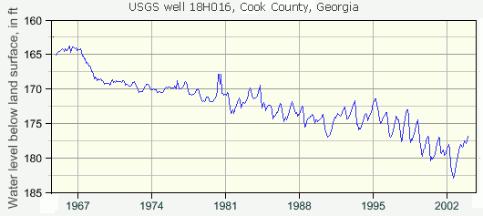
It would be interesting to follow that graph forward to the present for that Cook County USGS well 18H016. And we can, using USGS online data and graph:

In which it turns out that early 2000s upturn in water levels was more like increased variability, with the general trend continuing down in the same straight line since the 1960s. As the paper points out, the decrease in water levels is not due to decreasing rainfall. While rainfall may be somewhat less (especially in drought years), water levels are falling much faster. So overuse is the main most likely culprit, followed by clearcutting and impermeable surfaces for roads and other development that cause rain to run off instead of sink into groundwater.
I was a little surprised to see flows in the three main WWALS Georgia rivers were highest in the Alapaha, then the Withlacoochee, and the Suwannee last. Although part of that is accounted for by measurements pretty far upstream at Fargo for the Suwannee, still that difference in flow probably partly accounts for why the biggest population centers are near the Withlacoochee and Alapaha, not the Suwannee. It’s the other way around in Florida, where there’s more water in the Suwannee.

-jsq
You can join this fun and work by becoming a WWALS member today!
Short Link: