
 There’s a reason
Valdosta’s water wells are 400 feet deep.
Its earlier, shallower wells were sucking up Withlacoochee River water that still leaks into groundwater.
Should we risk a fracked methane pipeline digging under that same river and possibly causing more sinkholes and underground movement of contaminants, some perhaps coming from the pipeline itself or its demands for pressure testing water?
There’s a reason
Valdosta’s water wells are 400 feet deep.
Its earlier, shallower wells were sucking up Withlacoochee River water that still leaks into groundwater.
Should we risk a fracked methane pipeline digging under that same river and possibly causing more sinkholes and underground movement of contaminants, some perhaps coming from the pipeline itself or its demands for pressure testing water?
Sustainability of Ground-water Resources, by William M. Alley Thomas E. Reilly O. Lehn Franke, 1 January 1999, U.S. Department of the Interior, U.S. Geological Survey – Publisher. In Box E on Page 63:
The Connection Between Surface-Water Quality and Ground-Water Quality in a Karst Aquifer
The Upper Floridan aquifer, which is the sole source of water supply for Valdosta, Georgia, and much of the surrounding area, receives large volumes of direct discharge from the Withlacoochee River through sinkholes in the streambed or off-channel. A highly interconnected conduit system has developed in the Upper Floridan aquifer in this area, which extends at least 15 miles from the sinkhole area. Chloride and isotopic data were used by Plummer and others (1998) to map the percentage of Withlacoochee River water in ground water in the Upper Floridan aquifer (Figure E-1). These data indicate that ground water in parts of the Upper Floridan aquifer contains high percentages of recently recharged Withlacoochee River water. Plummer and others (1998) note that, although the patterns shown in Figure E-1 are generally true over the area, extreme variations can occur at a given location, as would be expected because of the large variations and discontinuities in hydraulic properties in the karst environment and time-varying inflows of river water into the aquifer.
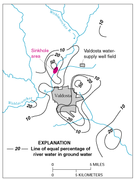
Figure E-1. Estimated percentage of Withlacoochee River water in ground water in the Upper Floridan aquifer, June 1991. (Modified from Plummer and others, 1998.)
The strong connection between the Withlacoochee River and ground water in the Valdosta area has created concerns about the potential for contamination of ground-water supplies by contaminants in the river. There also are concerns about the effects of natural organic matter in the river water. For example, in the early 1980’s, it was recognized that chlorination of aquifer water produced disinfection by-products in excess of drinking-water standards. This occurred as a result of reaction of chlorine with the high amounts of natural organic matter in the river water recharged to the aquifer.

Sinkhole near the Withlacoochee River. (Photograph by Richard E. Krause, U.S. Geological Survey.)
When Prof. Don Thieme gave a talk for WWALS at VSU 9 October 2013, he showed pictures of an example of this, the Cherry Creek Sink, which he said formed within about a month.

Back to USGS:
The original wells for Valdosta were near the city, in the areas where the aquifer contains a high percentage of river water. The city completed a new set of water-supply wells in the well field indicated in Figure E-1, in an area where the aquifer contains a relatively low percentage of river water. Even with this added level of assurance, it is still necessary to protect the surface waters that supply the aquifer. The source area of concern for ground water is the entire Withlacoochee River Basin upstream from Valdosta.
Bad news if you live downstream south of US 84 in Brooks or Lowndes or Florida.
And not just downstream. According to the City of Valdosta’s Water Treatment web page (I added the bolded emphasis),
Where Does Your Water Come From
The City of Valdosta obtains its water supply from eight (8) wells
that are drilled into an underground layer of porous, water bearing limestone known as the Upper Floridan Aquifer. This limestone layer lies under most of South Georgia and all of Florida. Generally, the aquifer is able to provide a prolific supply of good clean water. In Valdosta, the top of the aquifer lies approximately 200 feet below ground surface and the City’s wells are drilled an additional 200 feet into the limestone. The Floridan Aquifer in the area of Valdosta and Lowndes County is known as a karst aquifer. This is an aquifer that has cracks, underground solution channels, and caverns. These cracks can provide a route to allow contaminants to enter the aquifer, move about in the aquifer and alter the water supply and can cause special challenges for the City’s water system.
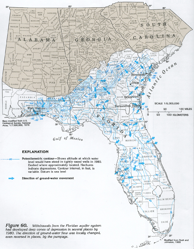
Note in that last sentence: “move about in the aquifer“. Remember that while the proposed Sabal Trail crossing of the Withlacoochee River just south of US 84 is southward and downstream on the river from Valdosta’s water wells, the water flow in the aquifer underground doesn’t necessarily flow in the same direction. Various city, county, and private uses of aquifer water could cause undergound flow to go in different directions from the river flow. And as you can see in another USGS figure below, it was already doing that in 1980.
Figure 60 Map
showing potentiometric contours and ground-water movement in the Floridan aquifer system in 1980 (608K)

There’s quite a bit of scientific literature about how water actually does move underground here in various directions at various levels, and how that has been affected over time by wells, sinkholes, and other disturbances of the fragile karst limestone substrate of the Floridan Aquifer.
Do we really want a company from Houston poking under our Withlacoochee River for their profit, leaving us all the hazards?
You can come paddle with WWALS past the other place Sabal Trail proposes to poke under the Withlacoochee River, and under the Suwannee River, on the WWALS outing 21 September 2014.
 And remember, even though
Sabal Trail is now making noises about moving off the
Withlacoochee River in Florida,
it has made no sound about moving off the Withlacoochee River
in Georgia at the Brooks-Lowndes County border.
Maybe we should ask it again to do so.
And remember, even though
Sabal Trail is now making noises about moving off the
Withlacoochee River in Florida,
it has made no sound about moving off the Withlacoochee River
in Georgia at the Brooks-Lowndes County border.
Maybe we should ask it again to do so.
-jsq
Short Link:
Pingback: Ground water depletion -USGS - WWALS Watershed Coalition
Pingback: WWALS signs letter to county commissions opposing the Sabal Trail pipeline - WWALS Watershed Coalition
Pingback: Withlacoochee and Suwannee paddle: springs, shoals, and pipeline 21 Sept 2014 - WWALS Watershed Coalition
Pingback: FL State Rep. Elizabeth Porter objects to FERC about Sabal Trail pipeline in karst limestone - WWALS Watershed Coalition