Tag Archives: cave

4610 foot explored cave at McIntyre Spring, Withlacoochee River, Georgia

Did you know there’s an almost mile-long cave system under the Withlacoochee River between Lowndes and Brooks Counties, Georgia? Valdosta cave-diver Guy Bryant wrote a fascinating in-depth blog about McIntyre Spring, including this map he drew, and the picture below of him in this cave system that starts in the river bottom.

There’s no land access, so don’t trespass. And don’t try to go in the cave even from boats unless you really know what you’re doing. It’s been visited by some of the most famous cave divers in the world, a couple of whom are no longer with us due to accidents in other underground caverns.

But do please go read Guy Bryant’s blog post. Continue reading

Sanford Bishop GA-02 requests Supplementary Environmental Impact Statement for Sabal Trail from U.S. Army Corps of Engineers 2016-05-27

Rep. Sanford Bishop GA-02 just stood up again against the Sabal Trail fracked methane pipeline invader, for the Flint River, the Floridan Aquifer, and his constituents in Albany, and Dougherty and Terrell Counties, pointing out FERC shouldn’t have issued a certificate before all the state Clean Water Act Section 401 permits were in, and asking for a Supplementary Environmental Impact Statement (SEIS).

Many counties and county seats have passed resolutions against Sabal Trail I’m sure we’re all looking forward to similar requests from Austin Scott GA-07, in whose Congressional district Sabal Trail would cross Okapilco Creek and the Withlacoochee River, and in which Moultrie, Valdosta, and the counties of Colquitt, Brooks, and Lowndes passed resolutions against the pipeline. And especially from Ted Yoho FL-03, in whose district Sabal Trail would cross the Suwannee and Santa Fe Rivers through the most vulnerable recharge area of the Floridan Aquifer in the Florida Springs Heartland, and in which the counties of Hamilton, Suwannee, and Marion have already sent letters to the Corps, like Rep. Bishop just asked for a Supplementary Environmental Impact Statement (SEIS).

We know the Corps did a SEIS for Keystone XL. The Corps should do a SEIS for Sabal Trail, so Continue reading

Geological determinations about Sabal Trail and Suwannee River by Dennis Price P.G.

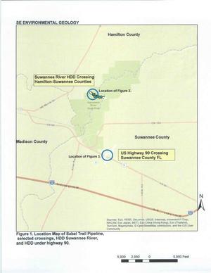
Sinkholes, springs, and caves abound where Spectra Energy wants to gouge its yard-wide Sabal Trail pipeline Figure 1. Location Map of Sabal Trail Pipeline through the heart of the Florida Springs Heartland, wrote a Practicing Geologist WWALS member to FERC, following up on his testimony in WWALS v Sabal Trail & FDEP.

Here is the text of the report by Dennis Price, followed by the images (PDF in FERC accession number 20151027-5034), all about the same area where WWALS board member Chris Mericle recently guided Hamilton and Suwannee County Commissioners to see for themselves. -jsq

Continue reading

Dead River Sink, Alapaha River, WWALS Outing, 2PM 26 Oct 2014

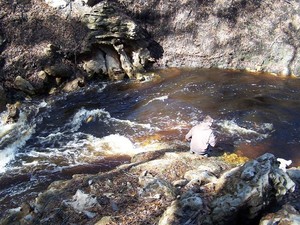
This Sunday afternoon, Oct 26th at 2PM: where the Dead River meets the Alapaha River and goes underground at the Dead River Sink, aka the Alapaha Sink. 300x149 Dead River Sink, in Jennings Bluff Tract, by SRWMD, 24 October 2014 Park on SRWMD’s Jennings Bluff Tract and walk in with WWALS to see what Samuel Taylor Coleridge dreamed as “Where Alph, the sacred river, ran Through caverns measureless to man Down to a sunless sea.” No boat required: this is a walking outing.

It’s an adventure, as Deanna Mericle reported recently:

300x225 Red with human for scale, in Alapaha Sink, by Chris Mericle, 16 September 2014 …the hike to the sink does have some steep parts, especially if you go the scenic route, which I recommend. The area around the sink itself is kind of steep with slick mud/clay. So wear good shoes for hiking. There were only a few Mosquitos. The area is beautiful and worth the effort.

This event is FREE! All we ask is Continue reading

Alapaha Sink: WWALS Outing 2PM 26 Oct 2014

300x225 Red with human for scale, in Alapaha Sink, by Chris Mericle, 16 September 2014 Update 24 October 2014: Map, directions, and how to join WWALS.

Come see where the Alapaha River goes underground, near Jennings, in Hamilton County, Florida, 2PM, Sunday, October 26th, 2014. This is a walking outing; no boats required.

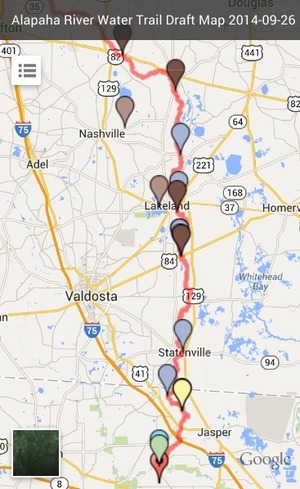
Directions to the parking area: Take I-75 south to State Road 6 in Florida. Go east (left) to US 41. Go north (left) about one mile. Turn right on NW 76th Terrace and go a mile. Turn right on NW 25th Lane and go about a mile. 300x489 Zoom, in Alapaha River Water Trail Draft Map, by John S. Quarterman, for WWALS.net, 26 September 2014 Turn left at the Jennings Bluff Tract sign and go .9 mile. It dead ends at the parking area. That road is gravel and dirt and kinda bumpy. The parking area can probably hold ten vehicles at least.

The location for the Sink on the draft Alapaha River Water Trail map apparently Continue reading

USGS warns Withlacoochee River already leaks into Floridan Aquifer

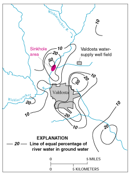
There’s a reason Valdosta’s water wells are 400 feet deep. Its earlier, shallower wells were sucking up Withlacoochee River water that still leaks into groundwater. Should we risk a fracked methane pipeline digging under that same river and possibly causing more sinkholes and underground movement of contaminants, some perhaps coming from the pipeline itself or its demands for pressure testing water?

Sustainability of Ground-water Resources, by William M. Alley Thomas E. Reilly O. Lehn Franke, 1 January 1999, U.S. Department of the Interior, U.S. Geological Survey – Publisher. In Box E on Page 63:

The Connection Between Surface-Water Quality and Ground-Water Quality in a Karst Aquifer


Figure E-1. Estimated percentage of Withlacoochee River water in ground water in the Upper Floridan aquifer, June 1991. (Modified from Plummer and others, 1998.)
The Upper Floridan aquifer, which is the sole source of water supply for Valdosta, Georgia, and much of the surrounding area, receives large volumes of direct discharge from the Withlacoochee River through sinkholes in the streambed or off-channel. A highly interconnected conduit system has developed Continue reading

Avoid our area –Florida’s Suwannee River Water Management District to FERC

What they told FERC today was more subtle than just “avoid our area”, but after the Sabal Trail methane pipeline avoid karst limestone, any unconfined areas of our Floridan aquifer, caves, springs, wetlands, drilling under rivers, blasting, or using groundwater for testing pipes or disposing of it afterwards, where can that pipeline go?

The Suwannee River Water Management District (SRWMD) covers the Florida parts of WWALS’ watersheds, and our Withlacoochee River is named in the SRWMD comments. Unlike Georgia’s Suwannee-Satilla Water management District, SRWMD has state funding and staff that produced some very interesting comments.

This is the first I’ve heard of this point about source and disposal of testing water: Continue reading