Tag Archives: Samuel Taylor Coleridge

Sulak’s Defeat at Jennings Defeat 2020-08-26

Explorer Dr. Ken Sulak has solved an Alapaha River rapids naming mystery. He recounts:


So in 1797, Samuel Taylor Coleridge wrote a poem inspired by a dream.

Where Alph, the sacred river, ran
Through caverns measureless to man
   Down to a sunless sea.

So twice five miles of fertile ground
With walls and towers were girdled round:
And there were gardens bright with sinuous rills,
Where blossomed many an incense-bearing tree;
And here were forests ancient as the hills,
Enfolding sunny spots of greenery.

Insert three ‘A” and the dreamscape river becomes the Alapaha, and appropriately so. Yesterday, I embarked on the foolish idea of a solo kayak journey up 3 miles of the Alapaha from Sasser Landing (just below the confluence of the Alapaha and the Alapahoochee rivers) to the site of the 1800s Roebucks Ferry and later Roebucks Bridge.

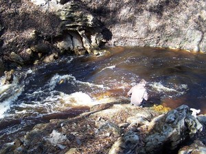
[Jennings Defeat Rapids, Ogeechee Gum, GS&F RR trestle below CR 150]
Jennings Defeat Rapids, Ogeechee Gum, GS&F RR trestle below CR 150

That crossing brought settlers and other travelers from Jacksonville and Fernandina along the GA/FL border across the Alapaha to Miccotown, the old Seminole Indian town in the triangle of land protected by the two flanking rivers. The road/trail (gone now on both sides) continued west across the Alapahoochee at the site of the early 1900s Beatty Bridge (undoubtedly preceded in the mid-1800s by an undocumented ferry), and on to Hickstown in Madison County and westward. Miccotown became the first county seat of Hamilton County as the settlers suppressed the Seminoles and the old Indian town faded into obscurity in 1839. Continue reading

Pictures: Hike to the Dead River Sink 2018-01-27

It was a nice day for a Hike to the Dead River Sink in the Alapaha Quest on the Alapaha River Water Trail, with Practicing Geologist Dennis J. Price of Hamilton County, Florida. Here are some pictures and a Google map from Saturday, January 27, 2018.

[Almost there, 13:16:34, 30.5837666, -83.0535975]
Almost there, 13:16:34, 30.5837666, -83.0535975

You can come along when we do it again in January 2019. Continue reading

Hike to Dead River Sink, Alapaha Quest 2017-01-27 2018-01-27

Update 2018-11-21: Pictures.

Rescheduled due to low water, this time moved and mutated into a hike to the Dead River Sink, starting in the middle of the Alapaha Quest.

Practicing Geologist and WWALS member Dennis James Price will once again lead us through this impressive geological phenomenon. It is an eye opener that will perfectly illustrate the karst topography that is typical for quite a bit of the area where many of our rivers flow. When you see the exposed limestone along the river banks you see the porous rock. However when you see a hole that is capable of swallowing the entire Alapaha for most of the year…. it’s impressive.

When: High noon, Saturday, January 27, 2018

Put In: Meet at Jennings Bluff Launch. From Jennings, Hamilton County, FL, travel south on US 41 to NW 25 Lane; turn left; travel east to NW 82 Court and the entrance into the Suwannee River Water Management District’s Jennings Bluff tract; turn left and follow road to canoe launch.

GPS: 30.567172, -83.039189 (for the entrance to Jennings Bluff Tract)

Take Out: Same.

Bring: Cold weather gear, hiking shoes, and clothes resistant to thorny bushes. No boat needed. Also trash pickers and trash bags: every WWALS outing is also a cleanup.

Join: This outing is Free to WWALS members. Non-members: $10/person. We recommend you support the work of WWALS by becoming a WWALS member today!

Event: facebook meetup


      Into the Dead River Sink
Picture by John S. Quarterman for WWALS, Into the Dead River Sink, June 14, 2015.

Shuttle: None.

Once you get to Suwannee River Water management District (SRWMD)’s Jennings Bluff Tract, Continue reading

Sasser Landing to Jennings Bluff & Dead River Sink 2015-06-14

See three sinks, a waterfall, and a distributary in these videos from the WWALS Outing to Turket Creek Waterfall, the Alapahoochee River, the Alapaha River Sink, and the Dead River Sink, June 14, 2015. A WWALS video playlist follows the links to each video below. Continue reading

Sasser landing to Jennings Bluff, WWALS Outing 2015-06-14

Update 2015-06-10: Expedition leader Chris Mericle writes:

I am pleased to report that the Alapaha River water level has increased since my last report (May 31). The Statenville gauge reports an increase of .9′ The Jennings gauage reports an increase of .8′. There should be plenty of water in the river for this weekend’s outing.

Float down the Alapaha River for a couple of hours, then walk to the Dead River Sink, where it disappears into the Floridan Aquifer. facebook event.

This is a pretty easy outing, but as always Continue reading

Dead River Sink, Alapaha River, WWALS Outing, 2PM 26 Oct 2014

This Sunday afternoon, Oct 26th at 2PM: where the Dead River meets the Alapaha River and goes underground at the Dead River Sink, aka the Alapaha Sink. 300x149 Dead River Sink, in Jennings Bluff Tract, by SRWMD, 24 October 2014 Park on SRWMD’s Jennings Bluff Tract and walk in with WWALS to see what Samuel Taylor Coleridge dreamed as “Where Alph, the sacred river, ran Through caverns measureless to man Down to a sunless sea.” No boat required: this is a walking outing.

It’s an adventure, as Deanna Mericle reported recently:

300x225 Red with human for scale, in Alapaha Sink, by Chris Mericle, 16 September 2014 …the hike to the sink does have some steep parts, especially if you go the scenic route, which I recommend. The area around the sink itself is kind of steep with slick mud/clay. So wear good shoes for hiking. There were only a few Mosquitos. The area is beautiful and worth the effort.

This event is FREE! All we ask is Continue reading

Alapaha Sink: WWALS Outing 2PM 26 Oct 2014

300x225 Red with human for scale, in Alapaha Sink, by Chris Mericle, 16 September 2014 Update 24 October 2014: Map, directions, and how to join WWALS.

Come see where the Alapaha River goes underground, near Jennings, in Hamilton County, Florida, 2PM, Sunday, October 26th, 2014. This is a walking outing; no boats required.

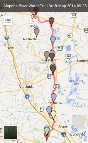
Directions to the parking area: Take I-75 south to State Road 6 in Florida. Go east (left) to US 41. Go north (left) about one mile. Turn right on NW 76th Terrace and go a mile. Turn right on NW 25th Lane and go about a mile. 300x489 Zoom, in Alapaha River Water Trail Draft Map, by John S. Quarterman, for WWALS.net, 26 September 2014 Turn left at the Jennings Bluff Tract sign and go .9 mile. It dead ends at the parking area. That road is gravel and dirt and kinda bumpy. The parking area can probably hold ten vehicles at least.

The location for the Sink on the draft Alapaha River Water Trail map apparently Continue reading