Update 2024-05-08: Sullivan Launch to Madison Boat Ramp, Withlacoochee River 2024-06-08.
Usually, Withlacoochee River water flows into this distributary into a sinkhole. But last Tuesday water was coming out into the river from the Chitty Bend East Distributary. So this swallet changed from a sink to a spring, and the creek changed from a distributary to a tributary.
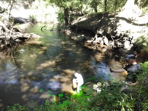
![[Chitty Bend East Distributary, Withlacoochee River 2024-04-30, Pumping out a stream --Amanda Davis]](https://www.wwals.net/pictures/2024-04-30--withlacoochee-swallet/fbmany.jpg)
Chitty Bend East Distributary, Withlacoochee River 2024-04-30, Pumping out a stream –Amanda Davis
Amanda Davis sent these videos that she took on Tuesday, April 30, 2024,
when the
Pinetta gauge was about 55.8 NAVD88.
https://youtube.com/shorts/UCE7siKv_ME
This is in Hamilton County, Florida, upstream from Florida Campsites Ramp and Madison Blue Spring.
WWALS last paddled in there Continue reading
![[Rapids, Spring, Distributary, Withlacoochee River 2023-07-15]](https://www.wwals.net/pictures/2023-07-15--withlacoochee-springs-slough-pictures/many.jpg)
![[Before and After]](https://www.wwals.net/pictures/2016-10-01--alapaha-swallets-dye-trace-project/many.jpg)
![[Hardee Spring, 2015-10-24]](https://www.wwals.net/pictures/2023-07-15--withlacoochee-springs-slough/KIMG2746.jpg)
![[Jennings Bluff State Geological Site and Dead River Sink 2023-03-17]](https://www.wwals.net/pictures/gretchen/2023-03-17--jennings-bluff-dead-river-pictures/many.jpg)
![[Jennings Defeat Rapids, Ogeechee Gum, GS&F RR trestle below CR 150]](https://www.wwals.net/pictures/2020-08-26--jennings-defeat/many.jpg)