Tag Archives: CP15-17

What is Sabal Trail sending into the WIthlacoochee River between Quitman and Valdosta, GA? WWALS PR 2016-11-09

Update 2016-11-14: GWC Dirty Dozen Press Conference at US 84 Bridge with tour of Sabal Trail HDD 2016-11-16

Update 2016-11-13:Sabal Trail still leaking drilling mud into the Withlacoochee River at US 84 in GA 2016-11-12

Update 2016-11-11: Sabal Trail leaked drilling mud up into the Withlacoochee River.

FOR IMMEDIATE RELEASE

Hahira, GA, November 9th 2016 — Sabal Trail appears to have contradicted itself in its recent responses to WWALS, perhaps admitting it may be dumping drilling mud into the Withlacoochee River, which would explain the picture below of a black pipe coming from Sabal Trail’s Brooks County HDD site into the river. WWALS had to wait two weeks just to get those non-answers, so WWALS now asks for a written response by email tomorrow. In addition, at least two Sabal Trail yards (a contractor yard in Moultrie, GA and a pipe yard near Lake City, FL) appear never to have been approved by FERC.
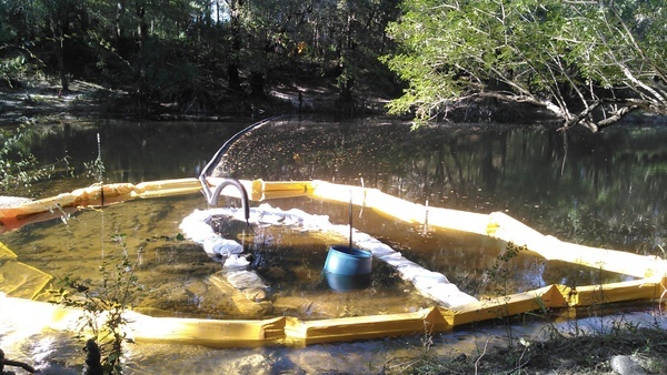
Dumping
About 2000 feet upstream (north) of the US 84 bridge. Many more pictures here.

“FERC granted permission in less than a week for Continue reading

CY3-6 full less than a day after FERC approval: Sabal Trail Moultrie contractor yard 2016-10-22

Less than a day after FERC rubberstamped (or did it?) Sabal Trail’s request for a new contractor yard on the east side of Moultrie, Georgia, WWALS saw that yard already full of materials. Did Sabal Trail really move everything in that fast, or were those things already there, like the notorious Lake City, Florida pipe yard that never has gotten any formal FERC approval that we’ve seen?

Here’s what we saw from the Southwings flight for WWALS on Saturday October 22nd 2016:

CY3-6 area of Sabal Trail overview map

Compare with the overview map Sabal Trail filed with its request to FERC of Monday October 17th 2016: Continue reading

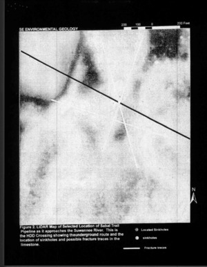
FERC makes Hamilton BOCC filing illegible

Does FERC actually look at what counties and other people send it?

Figure 2: LiDAR Map, Suwannee River --Dennis Price to FERC (5 of 8) FERC made the figures illegible in its posting of Dennis Price’s geology report that Hamilton BOCC appended when it forwarded to FERC its site visit request to the U.S. Army Corps of Engineers.

This reminds me of when FERC lost half of Dougherty County’s Sabal Trail resolution and just happened to lose page 3 of Bill Kendall’s letter, the page about lack of need, false pretense, and duress. Does FERC actually care what anybody thinks, other than the industries it “regulates” while they pay all its costs?

FERC Filing 28 March 2016, Accession Number 20160328-0091, “Correspondence from Board of County Commissioners of Hamilton, FL to U.S. Army Corp of Engineers re the Environmental Geology report under CP15-17.” Continue reading

Geological determinations about Sabal Trail and Suwannee River by Dennis Price P.G.

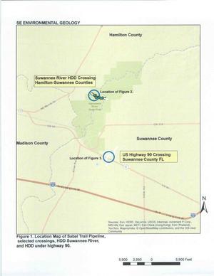
Sinkholes, springs, and caves abound where Spectra Energy wants to gouge its yard-wide Sabal Trail pipeline Figure 1. Location Map of Sabal Trail Pipeline through the heart of the Florida Springs Heartland, wrote a Practicing Geologist WWALS member to FERC, following up on his testimony in WWALS v Sabal Trail & FDEP.

Here is the text of the report by Dennis Price, followed by the images (PDF in FERC accession number 20151027-5034), all about the same area where WWALS board member Chris Mericle recently guided Hamilton and Suwannee County Commissioners to see for themselves. -jsq

Continue reading