Category Archives: Blueway

Videos: Naylor Boat Ramp should be finished in two weeks @ LCC 2019-06-10

The Naylor Boat Ramp on the Alapaha River should be finished in about two weeks, said Lowndes County Manager Joe Pritchard in yesterday morning’s Lowndes County Commission Work Session.

Below are videos of that meeting by Lowndes Area Knowledge Exchange (LAKE). Continue reading

Low water reroute of Paddle Georgia 2019-06-05

The same day as Jay Ricks, Paddle Georgia #PaddleGA2019, PaddleGA2019, sent an exploratory expedition, with WWALS board member Bobby McKenzie acting as local guide.

Canoe, Shoals

PADDLE GEORGIA 2019 LOW WATER UPDATE!!!!!

Due to low water levels on the upper Withlacoochee, the Georgia River Network staff and Paddle Georgia safety advisory committee has concluded that if water levels do not rise significantly, we will be forced to abandon our original Paddle Georgia route entirely.

This will mean all paddlers will travel on our “alternate route” which will involve repeating our original Day 4 and Day 5 routes during the week and paddling only a portion of our Day 3 route.

We have made this decision in an effort to Continue reading

Pictures: Troupville to US 84 –Jay Ricks 2019-06-05

Local resident Jay Ricks paddled the Withlacoochee River Wednesday, from Troupville Boat Ramp (which locals call the prison boat ramp, due to the state prison across the highway), to US 84.

[Rather low]
Rather low

This was the same day as the Paddle Georgia exploratory expedition.

Jay saw this odd sight at Troupville Boat Ramp: Continue reading

Shoals and Springs, Allen Ramp to SRSP, Withlacoochee River 2019-06-01

This Saturday, four shoals (Battery, Wipe-Out, Deer, and Melvin) and four springs (Powerline, Fairy, Corbett, and second-magnitude Suwannacoochee), all on the Withlacoochee River, from Allen Ramp to Suwannee River State Park.

[Shoals and springs]
Shoals and springs

Location of shoals from Chris Mericle, Blackwater River Guide. River mile calculations for them by Shirley Kokidko, both in the interactive map of the Withlacoochee and Little River Water Trail.

For outing details, see: Continue reading

Pictures: Banks Lake Full Flower and Osprey Moon Paddle 2019-05-18

We saw the pair of nesting ospreys at their nest, on the Banks Lake Full Flower Moon Paddle.

[Osprey, nest, bird watcher]
Osprey, nest, bird watcher

The sunset was impressive.

[Among paddlers]
Among paddlers

The moon came out from behind the clouds.

[Luna paddler]
Luna paddler

Paddlers of all Continue reading

Slab curing at Naylor Boat Ramp 2019-05-21

The concrete was curing Tuesday, May 21, 2019, that was poured after May 8, following the bed built by April 30.

[With representative human]
With representative human

Many people want to know: when will Lowndes County slide this slab down into the river? I am not Lowndes County Project Manager Chad McLeod, but my guess is Continue reading

Naylor Boat Ramp Park is not Lola VPA or WMA 2019-05-19

If you’re down at the beach on the Alapaha River, just upstream from US 84, in the new Lowndes County Naylor Boat Ramp Park, and a game warden should happen to say you need a WMA pass, please tell him you’re in a public park owned by Lowndes County, and if there’s any doubt about that, please consult the Lowndes County Tax Assessors online map, or call Lowndes County, or call me.

[Beach]
Beach, Lowndes County Tax Commission Map, Parcel 0259 030B.

There seems to be some confusion, possibly because the Georgia Department of Natural Resources (DNR) map for the Lola Tract WMA does not show Continue reading

Naylor Boat Ramp, Water Trails, and Paddle Georgia: WWALS to Lowndes County Commission 2019-05-13

Thanks and invitations from WWALS to the Lowndes County Commission, delivered in a letter via email and on paper Monday morning and in Citizens Wishing To Be Heard Tuesday evening.

WWALS to Lowndes County Commission 2019-05-14

I thanked

I invited the Commissioners to pass Water Trail resolutions (see below).

And I invited them to Paddle Georgia and the Suwannee Riverkeeper Songwriting Contest.

Letter

Continue reading

Statenville to Sasser Landing, Alapaha River, 2019-07-06

Update 2019-07-08: Pictures.

Experience the wilderness of the Alapaha River Water Trail on this 10.4 mile section with shoals. This run includes a side-jaunt up the Alapahoochee River to Turket Creek Waterfall, one of our favorite spots.

Or maybe a different stretch, or a different river, or a lake, if the water is really low. Check back before we paddle to see where we settle on for July.

When: 9:00 AM gather, 10:00 AM launch, Saturday, July 6, 2019

Put In: Statenville Boat Ramp, 206 GA 94 West, Statenville, GA 31648, in Echols County.

GPS: 30.70426, -83.03275

Take Out: Sasser Landing.

Bring: the usual personal flotation device, boat paddles, food, drinking water, warm clothes, and first aid kit. Also trash pickers and trash bags: every WWALS outing is also a cleanup.

Free: This outing is free to WWALS members, and $10 (ten dollars) for non-members. We recommend you support the work of WWALS by becoming a WWALS member today!

Event: facebook, meetup

600x450 Waterfall closeup, in Statenville to Sasser Landing on the Alapaha River, by John S. Quarterman, for WWALS.net, 15 February 2015
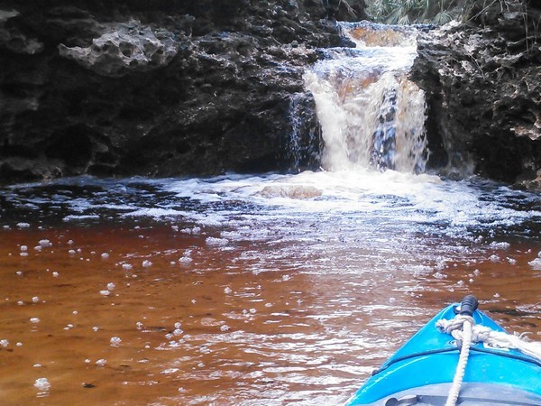
Photo: John S. Quarterman, Turket Creek Waterfall closeup, in Statenville to Sasser Landing on the Alapaha River, 15 February 2015.

We last did this February 15, 2015, when there was plenty of water, at 9.99 feet (86.09′ NAVD88) on the Statenville gauge, and only three hours paddle time. We’ll probably see opposite, low, conditions this time. Continue reading

Naylor Boat Ramp framed 2019-05-08

Frame and concrete wire.

[Frame]
Frame

Lowndes County Project Manager Chad McLeod says they will probably pour the concrete Saturday. Then 10 to 14 days to set before pushing into the Alapaha River for Naylor Boat Ramp. Continue reading