Tag Archives: Work Session

Sewer line repair between manholes, Bevel Creek Lift Station @ LCC 2020-06-22

Update 2020-12-23: Pictures of the repair in progress.

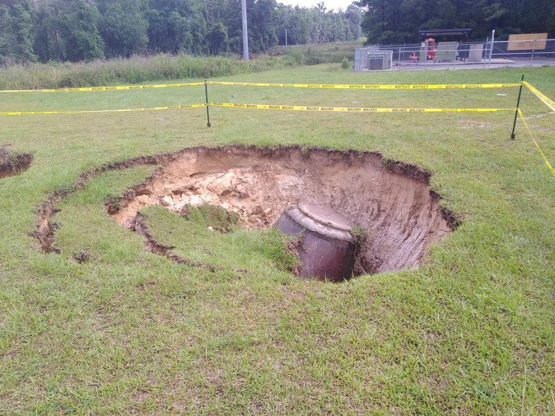
Lowndes County is fixing the June 8, 2020, sinkhole at the Bevel Creek Lift Station in a Floridan Aquifer recharge zone, with $82,000.00 to replace two manholes, to discuss at its Work Session 8:30 AM Monday morning, with voting at its 5:30 PM Regular Session Tuesday, June 23, 2020.

The county’s agenda sheet says:

Due to extensive flooding and undermining, the manhole before Bevel Creek lift station collapsed on June 8, 2020 creating an emergency situation. After accessing the problem it was determined the most feasible and economical method of repair was to replace two manholes and redirect the flow. RPI Underground submitted a quote not to exceed $82,000 to make the repairs. Staff recommends approval of the Bevel Creek manhole emergency repair by RPI Underground not to exceed $82,000.00.

Photo: Terry Richards, The Valdosta Daily Times, Heavy rains cause problems in Lowndes 2020-06-08.

Continue reading

Video: River Gauges @ Lowndes County Commission 2019-10-21

Flood Inundation Maps (FIM) are related to Lowndes County taking over funding from Valdosta of the Skipper Bridge Withlacoochee River gauge, said EMA Director Ashley Tye.

[19.7feet]
19.7feet

Joint funding of $135,000 from Valdosta and Lowndes County started work on FIM for Skipper Bridge in 2016, with completion announced 22 May 2018.

The item about joint funding with USGS and SRWMD to fund the Skipper Bridge Withlacoochee River Gauge, in addition to the Folsom Bridge Little River Gauge, was the longest item at five minutes yesterday morning. Continue reading

Lowndes County admits causing sinkhole; is fixing it 2019-06-24

On the Lowndes County Commission agenda for discussion this morning and voting tomorrow evening, is a rare case where the county admits to having caused a sinkhole, and is fixing the cause: KOA Lift Station Emergency Repair

The 8″ line between the manhole and lift station wet well has collapsed. This has created a sink hole effect with sand filling the wet well. A new manhole will be set and 40′ of 8″ pipe will be jack and bored to connect the new manhole to the wet well. RPI, Inc. has provided a quote for $49,400.00 to provide the materials and perform the work.

Lowndes County Utilities Director Steve Stalvey
Lowndes County Utilities Director Steve Stalvey, 8 May 2018.

The other item is not obvious: Continue reading

Videos: Naylor Boat Ramp should be finished in two weeks @ LCC 2019-06-10

The Naylor Boat Ramp on the Alapaha River should be finished in about two weeks, said Lowndes County Manager Joe Pritchard in yesterday morning’s Lowndes County Commission Work Session.

Below are videos of that meeting by Lowndes Area Knowledge Exchange (LAKE). Continue reading

Lowndes County lift station pumps 2018-08-13

Once again the Lowndes County Commission considers replacing a lift station pump at Bevel Creek. The agenda sheet says:

The Bevel Creek lift station is a triplex lift station on our main trunk line that delivers over 60% of our wastewater flow to the LAS. This station is currently running on two pumps. We have a quote from AAG Inc. to repair the pump that is out of service for $13,971.04. Staff recommends the pump be repaired for $13,971.04.

Replacing that pump sounds like a good idea. LAS is Land Application Site, as in spray field, a few thousand feet from the GA-FL state line and slightly upstream from the Withlacoochee River. Lowndes County does not have a wastewater treatment plant, and nobody wants sewage leaking at Bevel Creek or at the LAS.

Lowndes County Utilities Director Steve Stalvey
Lowndes County Utilities Director Steve Stalvey, 8 May 2018.

I do wonder, though, why we’re needing to replace a pump at Bevel Creek again, after just replacing Continue reading

Five water items at Lowndes County Commmision + a board appointment @ LCC 2017-02-14

If you care about water and sewage and water quality in wells and rivers, many county commission and city council decisions affect all of those. Here are some examples this week from the Lowndes County Commission (LCC), which represents the most populous county in the Suwannee River Basin, upstream from Florida.

Also, WWALS board member Phil Hubbard was appointed to Continue reading

$1.7 million sanitary sewer improvements, Lowndes County Commission 2017-01-10

Tonight at 5:30 PM the Lowndes County Commission will vote on a contract for $130,000 out of $1.734 million for sewer system improvements from a GEFA loan. This includes work at the Land Application Site (LAS), which Lowndes County uses instead of a wastewater treatment plant. The LAS is in the Withlacoochee River watershed. Here is video of discussion of this item from yesterday morning’s Work Session.

6.i. Engineering Services for Sanitary Sewer System Improvements

6 i. Engineering Services for Sanitary Sewer System Improvements

Video. Utilities Director said Carter & Sloope was the same firm who originally designed the Lowndes County Land Application Site. The agenda sheet says, apparently mis-spelling the name:

Continue reading

Not in our county, state, or aquifer: Valdosta votes against Sabal Trail pipeline tonight

Tonight at 5:30 PM the Valdosta City Council will vote on a resolution against the Sabal Trail pipeline they discussed Tuesday at their Work Session. Valdosta added a clause about the Floridan Aquifer to the clauses already in the resolution Lowndes County passed Tuesday evening that Valdosta is supporting. Valdosta’s aquifer clause reads:

WHEREAS, the City of Valdosta has concerns regarding any potential effect the proposed pipeline or its construction might have on the Floridan aquifer, the primary source of the drinking water supply for our City, County and the south Georgia area; and

As VSU Prof. Don Thieme remarked yesterday, Continue reading

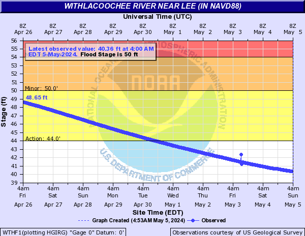
Flooding charts: Withlacoochee and Little Rivers

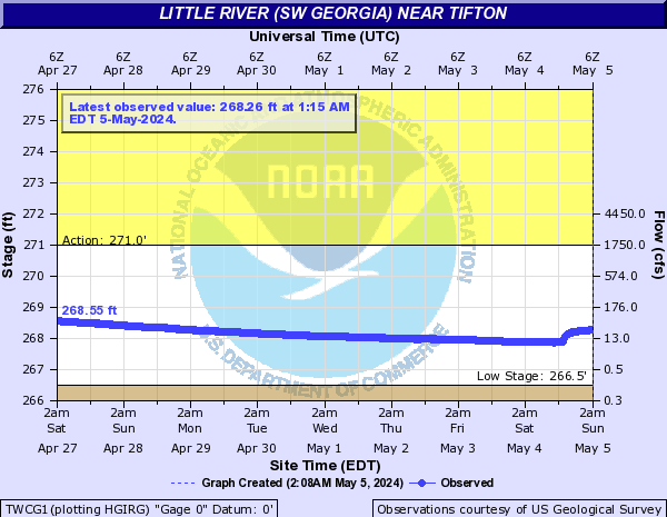
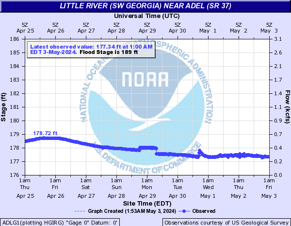
Related to the Withlacoochee and Little River Water Trail and the double USACE flooding study presentation tonight in Valdosta, here are river level charts upstream and down on the Little River, Okapilco Creek, and the Withlacoochee River related to a new USGS flood-tracking chart. In the example charts on the right, you can see the Little River peaked days ago at Tifton and yesterday at Hahira.

The Withlacoochee River peaked yesterday at US 41. while downstream it’s going up at US 84, and barely starting up at Pinetta (click on the above chart example for the rest). Right now you can see all that in the charts below. If this works, you’ll see something different later, because you’ll see current charts whenever you refresh this page.

Update 2016-05-31: See sea level gage reports.

Update 2016-04-27: graphs from water.weather.gov and some WRWT Safe Water Levels.

Update 2014-11-04: Simplified gage formatting.

Update 2014-11-03: That works, and see also Alapaha River water levels.


Tifton Gauge, Little River at Upper Ty Ty Road, near Tifton, GA, Tift County, GA (02317797)

Highest safe 3.9 feet, 271 NAVD. Lowest boatable 0.1 feet, 267.2 NAVD.
Adel Gauge, Little River near Adel, GA, Cook County, GA (02318000)

Highest safe 7.9 feet, 181 NAVD. Lowest boatable 2.2 feet, 175.3 NAVD.
Hahira Gauge, Little River at GA 122, near Hahira, GA, Lowndes County, GA (02318380)

Highest safe 11 feet, 144 NAVD. Lowest boatable 4.25 feet, 137 NAVD.

Skipper Bridge Gauge, Withlacoochee River at Skipper Bridge Road, near Bemiss, GA, Lowndes County, GA (023177483)

Highest safe 10.7 feet, 131 NAVD. Lowest boatable 2.3 feet, 122.6 NAVD.

Valdosta Gauge, Withlacoochee River at US 41 near Valdosta, GA, Lowndes County, GA (02317755)

Highest safe 12.7 feet, 123′ NAVD. Lowest boatable 5.7 feet, 116′ NAVD.

Okapilco Creek Gauge, Okapilco Creek at GA 333, near Quitman, GA, Brooks County, GA (02318700)

Quitman Gauge, Withlacoochee River at US 84, near Quitman, GA, Brooks County, GA (02318500)

Highest safe 10.5 feet, 94 NAVD. Lowest boatable 2.0 feet, 85.5 NAVD.

Pinetta Gauge, Withlacoochee River near Pinetta, FL., Madison County, FL (02319000)

Highest safe 12.5 feet, 59 NAVD. Lowest boatable 6.0 feet, 52.5 NAVD.

Madison Gauge, Withlacoochee River near Madison, FL , Madison County, FL (02319300)

Highest safe 10.0 feet, 50 NAVD. Lowest boatable 0.1 feet, 40.1 NAVD.

Lee Gauge, Withlacoochee River near Lee, FL, Madison County, FL (02319394)

Highest safe 44.0 feet, 44 NAVD. Lowest boatable 29.5 feet, 29.5 NAVD.
315x535 WRWT, in Withlacoochee River Water Trail gauges, by John S. Quarterman, for WWALS.net, 8 June 2015

 -jsq, John S. Quarterman, Suwannee RIVERKEEPER®

You can join this fun and work by becoming a WWALS member today!