Tag Archives: guage

Skipper Bridge, 17.66 feet, flood level 15 feet

The water level continued up from yesterday, when it was Downstream 31.0116939, -83.2915878 
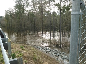
17.66 feet on the USGS guage at Skipper Bridge in Lowndes County, Georgia at 9:46 AM when I took these pictures. Flood stage is 15 feet. It was so high you could have floated over the chain link fence the county put in when it replaced the bridge, thus preventing normal use of this bridge 
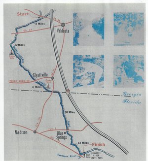
as a Withlacoochee River access point on the Withlacoochee and Little River Water Trail.

-jsq

You can join this fun and work by becoming a WWALS member today!

Downstream panorama 30.9016667, 83.2930556

Continue reading

Withlacoochee River at GA 122

This is a panorama; click on it to see the full picture.

See also Withlacoochee and Little River Water Trail and the pictures I took at Skipper Bridge a few minutes later. There’s a guage at Skipper Bridge, which read 17.66 feet, well above flood level.

-jsq

You can join this fun and work by becoming a WWALS member today!

Typical USGS streamgage costs with example near Okapilco Creek

Update 2021-03-09: The funding cost per gauge has gone up, to $22,500, of which usually the USGS contributes about $900.

How much would it cost to fund the Okapilco Creek gage so it won’t go offline July 31st? 300x342 Pie: Percentages of funding in various activities, in Streamgage Operation and Maintenance Cost Evaluation, by U.S. Geological Survey, for WWALS.net, 1 June 2010 About $13,600/year, more or less, mostly for field and office labor and administration, with only 10% for the field equipment. Since this gage is located in Brooks County, Georgia, the most likely funding body (after USGS itself) would be the Brooks County Commission. Yes, it’s in WWALS watersheds; no, WWALS doesn’t plan to take on funding streamgages. If some funding organization appeared that wanted to pass the funds through WWALS, which is a 501(c)(3) educational institution, that would be possible. But this seems more like a government issue.

Costs

Continue reading

Funding needed for Okapilco Creek gage

In USGS Groundwater Data for Georgia:

The following streamgage will be shut down on July 31, 2015 unless alternative funding can be found:

  • 02318700 Okapilco Creek at Georgia Highway 333, near Quitman, Georgia

For questions regarding this threatened streamgage, please contact Tony Gotvald at (678) 924-6648 or agotvald@usgs.gov.

-jsq

Canoeing Guide to the Withlacoochee River c. 1979

300x327 Map, in Canoe Guide to the Withlacoochee River Trail, by John S. Quarterman, for WWALS.net, 0  1979 Including both Florida and Georgia, a second river got map and guide attention back in the 1970s. To be updated in the Withlacoochee River Water Trail.

This Withlacoochee River guide is courtesy of John Leonard, Executive Director of the Southern Georgia Regional Commission (SGRC).


I would speculate that it is the most recent of the three guides posted thus far, because the Continue reading