Tag Archives: processes

Last day to comment to the Corps against strip mine near Okefenokee Swamp 2020-05-28

Today is the last public comment day to ask the Corps to stop a strip mine so close to the Okefenokee Swamp you can see both from a few hundred feet up.
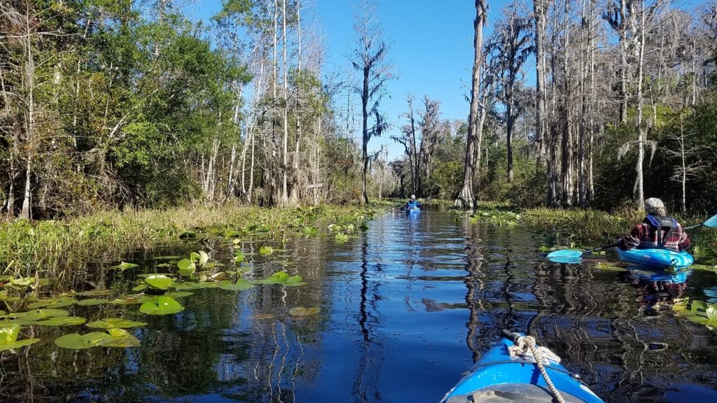
[Distant 2019-11-23]
Drone aerials of titanium mine site near Okefenokee Swamp 2019-11-23.

As the U.S. Fish and Wildlife Service told Georgia Sen. Purdue last November,

“The initial project location is the farthest that mining activity would be from the Okefenokee National Wildlife Refuge (NWR) boundary and the Okefenokee Swamp. Any additional mining that occurs within the 12,000-acre permit area would be closer to the refuge. The northwest boundary of the permit area is within a half mile from the refuge boundary and 400 feet from the edge of the Okefenokee Swamp.”

FWS also spelled out the bottom line: “It is the responsibility of the permit applicant to demonstrate what the extent of impacts of the project will be to surrounding natural resources.”

And the applicant still has not done that, not even in its second application.

A few miners profiting by selling titanium dioxide for paint is nowhere near sufficient reason to risk the unique treasure that is the Okefenokee Swamp, which is also the headwaters of both the Suwannee and St. Marys Rivers.

Please comment to the Corps

Today you can still ask the U.S. Army Corps of Engineers to stop this strip mine:
To: CESAS-SpecialProjects@usace.army.mil
Re: Applicant: Twin Pines Minerals, LLC, Application Number: SAS-2018-00554

Be sure to ask the Corps to deny the permit, or at least to require an Environmental Impact Statement.

Or use the convenient comment form in this Action Alert by Waterkeeper Alliance:
https://waterkeeper.org/news/take-action-protect-okefenokee-swamp-from-a-titanium-mine/

Or this convenient comment form by Georgia River Network:
https://www.congressweb.com/GEAN/225

For far more information about this bad strip-mining proposal, see:
https://wwals.net/issues/titanium-mining/

 -jsq, John S. Quarterman, Suwannee RIVERKEEPER®

You can join this fun and work by becoming a WWALS member today!

Any additional mining would be closer to the refuge. –FWS to Sen. Perdue 2019-11-21

“The initial project location is the farthest that mining activity would be from the Okefenokee National Wildlife Refuge (NWR) boundary and the Okefenokee Swamp. Any additional mining that occurs within the 12,000-acre permit area would be closer to the refuge. The northwest boundary of the permit area is within a half mile from the refuge boundary and 400 feet from the edge of the Okefenokee Swamp,” wrote the Fish and Wildlife Service to Senator David Purdue.

You can still comment to the Army Corps demanding an Environmental Impact Statement.

Minnie Lake, Shirley Kokidko, Gretchen Quarterman, 11:42:54,, Minnie Lake
Photo: John S. Quarterman, Okefenokee Swamp, 2017-12-10

The U.S. Fish and Wildlife Service (FWS) wrote that in response to an inquiry by Senator David Perdue of Georgia. Sen. Perdue also asked if FWS actually had jurisdiction over the proposed mining area, and FWS replied saying that it did have several kinds of oversight.

But FWS spelled out the bottom line: “It is the responsibility of the permit applicant to demonstrate what the extent of impacts of the project will be to surrounding natural resources.”

And the applicant still has not done that, not even in its second application.

No longer discussing the northern reaches of its landholdings much doesn’t mean Continue reading

Deadline for FERC rulemaking comments 2018-07-25

In addition to probably signing onto comments by a larger entity, WWALS is preparing comments for FERC in response to its Notice of Inquiry (NOI) about “Certification of New Interstate Natural Gas Facilities”. FERC’s current deadline is this Wednesday, 25 July 2018. Please send any suggestions you may have to wwalswatershed@gmail.com. Or file your own comments. Apologies for the late request.

Here’s what FERC has asked for:

In the NOI, the Commission sought input on whether, and if so how, the Commission should adjust: (1) its methodology for determining whether there is a need for a proposed project, including the Commission’s consideration of precedent agreements and contracts for service as evidence of such need; (2) its consideration of the potential exercise of eminent domain and of landowner interests related to a proposed project; and (3) its evaluation of the environmental impact of a proposed project. The Commission also sought input on whether there are specific changes the Commission could consider implementing to improve the efficiency and effectiveness of its certificate processes including pre-filing, post-filing, and post-order issuance.

South Georgia and north Florida
Sabal Trail through south Georgia and north Florida.
Map by Geology Prof. Can Denizman for WWALS.net, 17 September 2016, as part of Sabal Trail maps digitized.

Here are some relevant documents, starting with a how-to in case you want to file your own comments directly with FERC: Continue reading