Tag Archives: rapids

Pictures: Sullivan Launch to Madison Blue Spring Withlacoochee River 2015-10-24

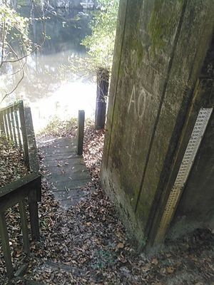
Update 2022-07-20: better picture labels and access.

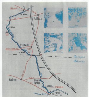
A fine day, balmy, breezy, sunny, with springs and rapids and fine company, Onwards from Hardee Spring 30.5444069, -83.2500076 from Sullivan Launch to Madison Blue Spring on the Withlacoochee River, in the October WWALS Outing, October 24, 2015. This is part of the Withlacoochee and Little River Water Trail, and you can join the committee!

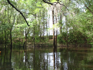
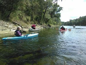
Below are some pictures. Click on any small picture to see a larger version. Pictured: many shoals and rapids. The Pinetta gage (pictured) read 6.4 feet. Any lower and more dragging boats would have been necessary. Lots of cypress, oaks, pines, and other native species.

Pinetta Gage steps and old-style measure 30.5957374, -83.2598038 Not pictured: a large turtle, numerous birds (heron, ibis, hawk, buzzard, others), and fish (mullet, bass). No gators. Very few invasive species, except the notorious Japanese climbing fern.

Coming up next: Continue reading

Canoeing Guide to the Withlacoochee River c. 1979

300x327 Map, in Canoe Guide to the Withlacoochee River Trail, by John S. Quarterman, for WWALS.net, 0  1979 Including both Florida and Georgia, a second river got map and guide attention back in the 1970s. To be updated in the Withlacoochee River Water Trail.

This Withlacoochee River guide is courtesy of John Leonard, Executive Director of the Southern Georgia Regional Commission (SGRC).


I would speculate that it is the most recent of the three guides posted thus far, because the Continue reading

Sabal Trail avoid sensitive karst regions –Hamilton County FL Commission to FERC

Last Friday a resolution to FERC saying the Sabal Trail fracked methane pipeline should avoid sensitive karst limeston regions affecting water resources passed the Hamilton County, Florida Commission.

Joyce Marie Taylor has added the following to her article in the Suwannee Democrat 25 August 2014, Hamilton fights back against Sabal Trail pipeline,

A special meeting was called on Friday, Aug. 22, and the board voted to pass Resolution 14-10 that expressed their concerns about the proposed pipeline route across the Withlacoochee River that forms the western boundary of Hamilton County.

A portion of the resolution states, Continue reading

Protect the Withlacoochee River from the Sabal Trail Pipeline –Chris Mericle at the Hamilton County Commission

Chris Mericle, local host for the September WWALS Outing, spoke to the Hamilton County Commission last Tuesday about the same section of the Withlacoochee River, where the Sabal Trail fracked methane pipeline is proposed to cross. You can come float past it yourself Sunday 21 September, and see many local springs, sinkholes and shoals that need to be protected from that pipeline, continuing on to where the pipeline would cross the Suwannee River.

Joyce Marie Taylor wrote for the Suwannee Democrat 25 August 2014, Hamilton fights back against Sabal Trail pipeline, Continue reading

Withlacoochee River Outing: Clyattville-Nankin Road to GA 31

The June WWALS outing is from Clyattville-Nankin Road to Horn Bridge on Sun tree Madison Highway (GA 31) on the Withlacoochee River. Meet at the Clyattville-Nankin Road putin at 9AM, put in at 10AM, Saturday, 22 June 2013. Join the facebook event if you like. See you there!

Update 20 June 2013: How are we getting back to our vehicles with this trip? We’ll deposit all the boats at the put-in (Clyattville-Nankin Road), take most of the vehicles down to the take-out (Horn Bridge on Madison Highway aka GA 31), carpool in a few vehicles back to the put-in, and float down the river.

Tom Baird described this nine-mile two-hour trip as:

The section includes where Clyatt Mill Creek enters, a truly fun set of rapids (two drops) at the Ga – Fla border, a very nice Second Magnitude Spring (that I have yet to find the correct name), the remains of the enormous abandoned trestle over the river of the Georgia & Florida Railroad, or Ole God Forsaken as it was nicknamed, the ghost town of Olympia on the Georgia side, and several Indian quarry sites. It is along this section that the river cuts deeply enough that the banks switch from sand banks to limerock cliffs. Paddle distance is about 9 miles, so a little over two hours paddling time. There are plenty of places to stop and look around.

There are shoals right at the state line, so beware, esp. if you’re in a canoe. The book Canoeing and Kayaking Georgia, by Susanne Welander, Bob Sehlinger, and Don Otey (2004) says: Continue reading