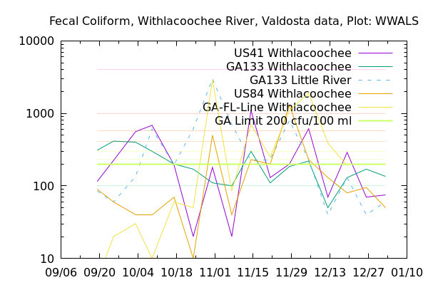
Tag Archives: USGS

EPA considering abandoning Floridan Aquifer?

The new water rule EPA plans to propose may be much more about all our drinking water underground in Florida and south Georgia than about anybody’s private pond.

Stacey H. Mitchell, David H. Quigley and Bryan Williamson, Akin Gump Strauss Hauer & Feld LLP, 11 December 2018, United States: Dipping Its Toe In The Groundwater? Supreme Court Eyes Expedited Review For Clean Water Act Case,

Specifically, the Court aims to address a circuit split among the 4th, 5th and 9th Circuits in determining whether only direct discharges to “navigable waters” (rivers, lakes and other surface waters, for example) are covered or whether groundwater that is “hydrologically connected to surface water” is subject to Clean Water Act (CWA) pollution discharge requirements.2 Groundwater—that is, water held beneath the soil or in between rock structures—does not fall under CWA jurisdiction. Nevertheless, the U.S. Environmental Protection Agency (EPA), for many years, maintained that pollutants that flow with a direct and immediate hydrologic connection through groundwater into surface waters are properly regulated under the CWA.3 Environmentalists agree with EPA’s long-standing position, while many in industry say that the agency is reaching beyond its scope.

Surface water interchanges with groundwater all the time here in the southeast coastal plain, where we all drink with straws from the groundwater.


Figure from same USGS study as below.

This SCOTUS case appears to be related to the forthcoming EPA rule change proposal that has been all over the news lately. More from the same article: Continue reading

Bacteria levels all dropped 2018-12-12

Bacterial levels at all stations Valdosta tests dropped this week, according to the Wednesday 12 Dec 2018 test results returned for a WWALS open records request.

Graph, Withlacoochee

The only station above the 200 cfu/100 ml Fecal coliform limit was at Continue reading

Over the Fecal coliform line at the state line, Withlacoochee River 2018-12-05

Another mysterious rise of bacterial counts at Horn Bridge, at Mozell Spells, near State Line Ramp, Withlacoochee River, in the latest data from Valdosta, from Wednesday, December 5, 2018, obtained as usual through open records request.

Graph, Withlacoochee

Continue reading

Bacterial levels rising again 2018-11-28

The Alapahoochee River at the GA-FL line measured ten times the EPA limit on Fecal coliform again this Wednesday, November 28, 2018.

GA 135 Alapahaoochee River, Alapaha

It does not seem to be coming downriver from Valdosta. Continue reading

Much better readings in Valdosta water quality data 2018-11-21

Suddenly, all the fecal coliform readings are down. Was there a first flush from the rain on November 14 that caused the high readings of that day, and all that washed down the rivers within a week?

Graph, Withlacoochee Basin

At US 41 (North Valdosta Road), the Withlacoochee River was actually in minor flood several of the intervening days, according to the USGS US 41 (Valdosta) Gauge. Continue reading

What happened on the Alapahoochee River? 2018-11-14

Twenty five times the state limit for Fecal coliform could be a problem. What got into the Alapahoochee River last week?

Graph, Alapaha Basin

GA 135, Alapahoochee River, Alapaha Basin

If you want to help find out what’s getting into our rivers, you can Continue reading

First flush 2018-10-31

Was there rain Wednesday? That might explain the sudden spikes at US 41 on the Withlacoochee River, at GA 133 on the Little River, and at State Line on the Withlacoochee River. We can guess that the rains Thursday and Friday (today) have washed away whatever that very odd spike was at the state line.

Graph, Withlacoochee Basin

Thanks to Valdosta Utilities and Valdosta City Clerk Teresa Bolden for sending this Wednesday’s Valdosta water quality testing data before the end of Friday. For more contact, see https://wwals.net/issues/vww/.

State Line, Withlacoochee River, Withlacoochee Basin

It’s a very odd spike, because Continue reading

Low bacterial counts at State Line Ramp 2018-10-24

Valdosta’s bacterial counts are always low at State Line Ramp (Mozell Spells), where we moved the WWALS Boomerang paddle race from Georgia to Florida and back.

State Line, Withlacoochee River, Withlacoochee Basin

Things were generally better last week in the Withlacoochee Basin, except for the Little River at GA 133, just above Troupville Boat Ramp. Continue reading

Five weeks and fecal coliform down 2018-10-17

Fecal coliform went down last week to 195 at US 41 and 200 at GA 133 on the Withlacoochee River, right at the Georgia limit of 200 cfu/100 ml, while rising slightly at US 41 and at the GA-FL line at the Madison Highway Horn Ferry Bridge, according to Valdosta’s testing.

Graph, Withlacoochee Basin

Wednesday of this week, we still don’t know, because Continue reading

Suwannee tributaries flooding 2018-08-07

Once again, as during Hurricane Irma, recent rains are causing flooding on Suwannee River tributaries.

Suwannee River Basin, Map

The Withlacoochee River at Skipper Bridge and at US 41 (North Valdosta Road) is in Near Flood Stage, as is the Suwannee River at Fargo, and the New River near Lake Butler.

Already in Minor Flooding are Continue reading