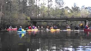
 Second annual BIG Little River Paddle Event
held on the sunny rescheduled Saturday morning 29 March 2014 at Reed Bingham State Park.
Second annual BIG Little River Paddle Event
held on the sunny rescheduled Saturday morning 29 March 2014 at Reed Bingham State Park.
Continue reading

Second annual BIG Little River Paddle Event
held on the sunny rescheduled Saturday morning 29 March 2014 at Reed Bingham State Park.
Continue reading
 Second annual BIG Little River Paddle Event
held on the sunny rescheduled Saturday morning 29 March 2014 at Reed Bingham State Park.
Second annual BIG Little River Paddle Event
held on the sunny rescheduled Saturday morning 29 March 2014 at Reed Bingham State Park.
 Second annual BIG Little River Paddle Event
held on the sunny rescheduled Saturday morning 29 March 2014 at Reed Bingham State Park.
Second annual BIG Little River Paddle Event
held on the sunny rescheduled Saturday morning 29 March 2014 at Reed Bingham State Park.
Update 9PM 16 April 2014: Cancelled due to flood-stage water levels in the Withlacoochee River, with more rain expected Friday. To be rescheduled.
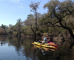
7:30 AM Saturday 19 April 2014 on the Withlacoochee River
between Valdosta and Quitman,
 put in at Old Quitman Road on the Brooks County side (just south of US 84):
Paddle past where the proposed Sabal Trail methane pipeline
would cross the Withlacoochee River, digging into our fragile
karst limestone, above our drinking-water Floridan Aquifer.
This is a joint event of Continue reading
put in at Old Quitman Road on the Brooks County side (just south of US 84):
Paddle past where the proposed Sabal Trail methane pipeline
would cross the Withlacoochee River, digging into our fragile
karst limestone, above our drinking-water Floridan Aquifer.
This is a joint event of Continue reading
 The BIG Little River Paddle Event will take place this Saturday rain or shine, but may be delayed if there is thunder or lightning.
You can register online or at the event.
 You should see these billboards around Valdosta starting today.
Thanks to Fairway for the artwork.
You should see these billboards around Valdosta starting today.
Thanks to Fairway for the artwork.
There’s still time to register online or by sending a check, for the Second Annual BIG Little River Paddle Event, at Reed Bingham State Park, this Saturday, 22 March 2014, to benefit Friends of Reed Bingham State Park and WWALS Watershed Coalition.
Continue reading
 On 19 February 2014 WWALS Watershed Coalition received the appended
letter from the United States Air Force about a study
regarding encroachment around Moody Air Force Base,
between Valdosta and Lakeland in Lowndes and Lanier Counties,
in the watershed of the Alapaha River.
Several documents were attached:
On 19 February 2014 WWALS Watershed Coalition received the appended
letter from the United States Air Force about a study
regarding encroachment around Moody Air Force Base,
between Valdosta and Lakeland in Lowndes and Lanier Counties,
in the watershed of the Alapaha River.
Several documents were attached:
 About the ICEMAP
From: Mike Lynch <ml@marstel-day.com>
Date: Wed, Feb 19, 2014 at 10:32 AM
Subject: Moody Air Force Base Installation Complex Encroachment Management Action Plan (ICEMAP)
To:
Cc: "NICHOLS, DIONDRA R GS-11 USAF ACC 23 CES/CENPP" <diondra.nichols@us.af.mil>
On behalf of Headquarters Air Force and the 23d Wing, Marstel-Day, LLC is developing an "Installation Complex Encroachment Management Action Plan" (ICEMAP) for Moody Air Force Base (AFB), Georgia and its associated installations and facilities. Attached is a memo Continue reading
Stroud Water Center wrote in their Upstream Newsletter, VOL. 2014, ISSUE 1, February 2014,
Scientists Set Buffer Width Minimum Standard.
A strip of forest along a stream channel, also called a riparian forest buffer, has been proposed and used for decades as a best management practice to protect streams by filtering out contaminants from agriculture and other land uses before they can enter them.Their benefits are many, but one benefit has dominated social and political conversations, and that is their role in preventing contaminants from entering streams.
A few years ago, Stroud Water Research Center proposed that riparian forest buffers also play another important role by Continue reading
 Interesting interactive map by
Georgia Department of Natural Resources,
Georgia Outdoor Map.
Their PR of 14 March 2014,
DNR Launches Interactive Map of Recreational Lands,
Interesting interactive map by
Georgia Department of Natural Resources,
Georgia Outdoor Map.
Their PR of 14 March 2014,
DNR Launches Interactive Map of Recreational Lands,
The Georgia Department of Natural Resources (DNR) today unveiled an interactive map that identifies DNR-managed lands and outdoor recreation opportunities. The “Georgia Outdoor Map” includes state parks, wildlife management areas, public fishing areas, boat ramps, and historic sites. Users are able to search by category to find locations where they can camp, hunt, hike, fish or explore history.
Continue reading
