Tag Archives: Maps

Ockolocoochee, Little River 1889-01-29

Who knows the Ockolocoochee River? No, not the Ochlockonee River; that’s a bit to the west.

[Withlacoochee River labeled Suwanee R. in 1823 Irwin and 1834 Lowndes County maps; current WWALS Withlacoochee and Little River Water Trail map]
Withlacoochee River labeled Suwanee R. in 1823 Irwin and 1834 Lowndes County maps; current WWALS Withlacoochee and Little River Water Trail map

You do know the Ockolocoochee River as the Little River, of the Withlacoochee, of the Suwannee.

Here is news from 1889 that also includes the boat that didn’t survive from Troupville to Ellaville, which was apparently not a paddlewheel steamer. Continue reading

Suwannee River Basin is bigger than several states, less populous than any

Suwannee Riverkeeper and WWALS work for fishable, swimmable, drinkable water in all 10,000 square miles of the Suwannee River Basin and Estuary.

But how big is that, compared to what? Other river systems, states, cities, territories?

[Rivers and Districts]
Rivers and Districts

Land Area

The Basin covers 9,950 square miles, plus some harder-to-estimate land and water area for the Estuary. See How big are WWALS Watersheds?

RiverGeorgiaFloridaTotal
Withlacoochee2,0902702,360
Alapaha1,7261141,840
Upper Suwannee River1,9048162,720
Lower Suwannee River01,590 1,590
Santa Fe River01,4001,400

Suwannee River Basin5,7204,2309,950

So 10,000 square miles is a good guess for the total land area.

Rivers Area

The Suwannee River Basin is one of the larger ones hereabouts, but far from the largest. Continue reading

Titusville LNG denied by PHMSA 2018-10-02

Two years later, PHMSA still lists New Fortress Energy’s Titusville LNG facilty as Denied.

The missing piece in NFE’s application? A “Draft Environmental Assessment (DEA)” with “site drawings, maps, and other supporting documents.”

Funny how when a liquid natural gas (LNG) facility has to submit these things, often it can’t.

With the LNG market overseas cratering, maybe this one will stay dead. But we must keep watch to be sure it does not reappear, zombie-like, right in the middle of Florida’s Atlantic coast, able to ship by truck and rail as far as Jacksonville and Miami, as well as overseas.

[LNG--TITUSVILLE--PHMSA--LETTER-DENYING-APPLICATION--10.02.18-0001]
LNG–TITUSVILLE–PHMSA–LETTER-DENYING-APPLICATION–10.02.18-0001
PDF

The denial letter is Continue reading

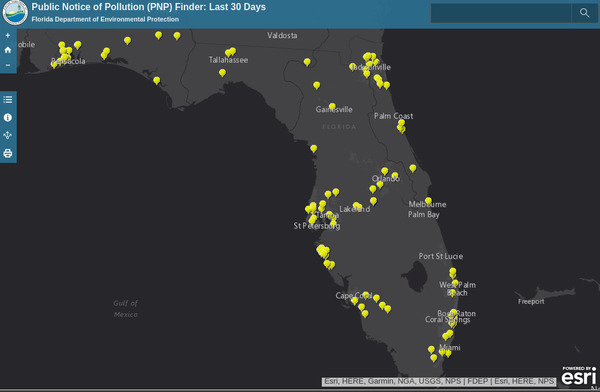
FDEP now maps last 30 days of spills

Pollution spill maps online, up to date, with interactive links to details: Florida is doing it, and so can Georgia.

Florida, Maps

For more than a year FDEP has been posting spill reports online in a spreadsheet the same day it gets them, with email notice signup (Alabama also does that). FDEP has added a Public Notice of Pollution (PNP) Finder: Last 30 Days, which helps a lot in finding spills in our watersheds.

Did you know there was a Phosphoric Acid spill at White Springs last week, on Continue reading

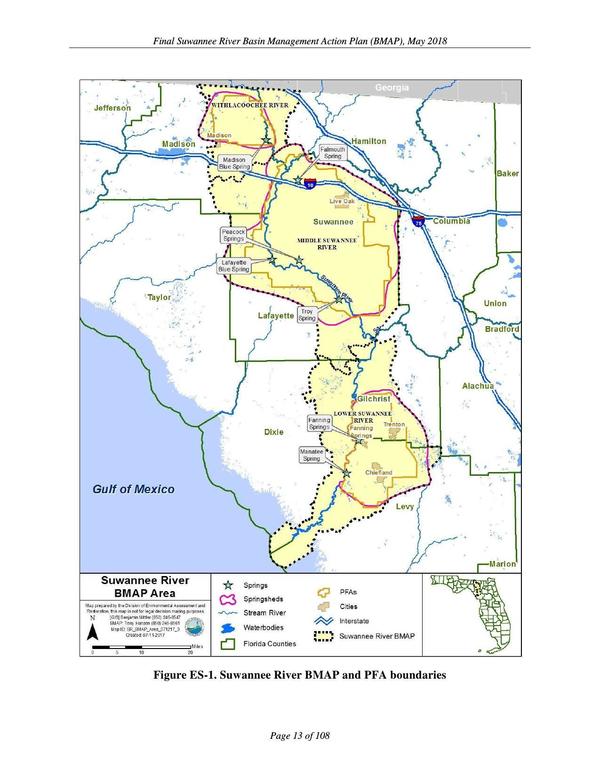
Final Suwannee River BMAP 2018-05-22

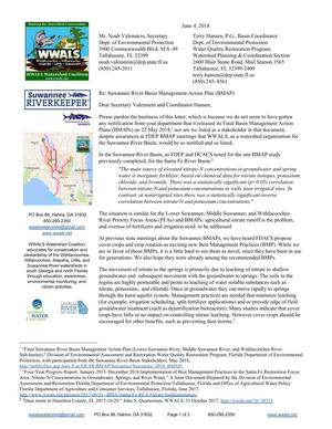
Did you know the Final Suwannee River BMAP was released last week? Apparently not many others did, either. Here’s the letter I sent FDEP about that.

Suwannee River BMAP and PFA boundaries, The Problem


PDF

 June 4, 2018

Nitrate above and below ground, Pages Mr. Noah Valenstein, Secretary
Dept. of Environmental Protection Continue reading

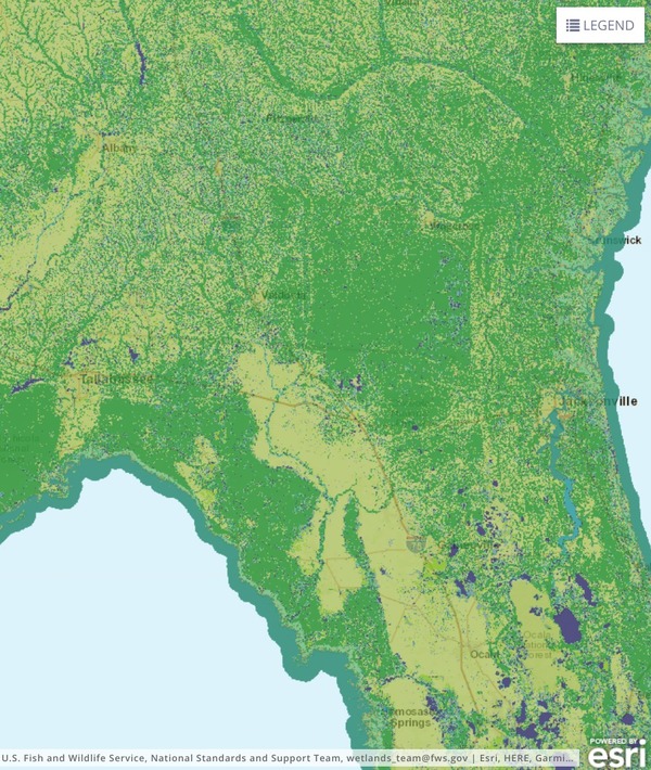
National Wetlands Inventory

The National Wetlands Inventory (NWI) by the U.S. Fish and Wildlife Service (FWS) provides data on wetlands throughout the country, plus a mapper, from which I’ve pulled these stills of the Suwannee River Basin.

Wide, Basin

I used a topo map as background.

Phosphate Mines

One that already exists, and where another one wants to be.

PCS, Hamilton Co., FL, Phosphate mine

All those straight lines don’t look natural, because Continue reading

Suwannee River Basin Maps

Update 2019-02-13: And a version with Landings. See also Water Trails, with more detailed maps and access points.

Nobody seems to have done this, so we did: a map of the Suwannee River Basin, with the major watersheds and the Estuary shaded, and all the major rivers, plus many of the creeks. Bonus: springs! Narrow, Suwannee River Basin Click on this link for an interactive google map of the Suwannee River Basin.

The river traces come from USGS and Chris Graham. The watershed boundaries are from USGS. The springs are from the Florida Springs Institute, plus four Georgia springs collected by WWALS.

The eight-digit hydrologic unit codes (HUC8) for the Suwannee River Basin are: Continue reading

Crowdsourcing pictures of Sabal Trail path

Update 2016-11-29: Added to this google map: WWALS aerials of Gilchrist County, and Sabal Trail alignment maps localized by LAKE for Mitchell, Colquitt, Brooks, and Lowndes Counties, Georgia, and Hamilton, Suwannee, and Gilchrist Counties, Florida to just north of Bell, FL.

Update 2016-11-04: Now with Sabal Trail route digitized through Gilchrist, Alachua, and part of Levy Counties, plus part of the Citrus County line.

Signs, silt fences, backhoes in wetlands: you can log pictures on a map of anything going on at a Sabal Trail construction site from your mobile phone, tablet, or laptop. Already posted your pictures on the web? Link them into the map. Here’s how.

You’ve seen many pictures posted by WWALS, taken on the ground and in the air, and linked into a google map (which also has Sabal Trail’s alignment maps linked in).

Here’s another google map, to which more people can add pictures.

If you want to add pictures to this new crowdsourcing google map, you need to: Continue reading

All 527 Sabal Trail alignment maps from April 2016

Courtesy of Lowndes Area Knowledge Exchange, you can now see small, big, huge, and PDF versions of all 527 alignment maps Sabal Trail filed with FERC in April 2016: follow this link.

[STA. 11870+00 TO STA. 11923+00, (UT OKAPILCO CREEK), 11881+44 CL SPAIN ROAD, 11871+70 CL GOLDING ROAD, BROOKS COUNTY, GEORGIA]

Having these maps online like this makes it easier to see what’s in them. Sabal Trail told FERC Okapilco Creek was not among the streams for which the Georgia legislature denied river-drilling easements (and for which Sabal Trail got the easements later anyway by suing the state in county Superior Courts). Yet Sabal Trail’s alignment maps from April 2016 seem to say that fracked methane pipeline crosses Okapilco Creek a couple of times in Brooks County, Georgia.

Here’s one of those times, in which the road names don’t match Continue reading

Sabal Trail maps digitized

Update 2019-03-19: The google map now includes Florida Southeast Connection (FSC) and FPL’s Martin County to Riviera Beach (MR-RV) pipeline to the sea, which FPL in 2018 got FPSC and FERC to roll into FSC. See also Stop FERC Shirking LNG Oversight.
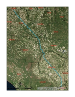
South Georgia and north Florida Update 2016-12-13: The google map now includes the Sabal Trail path digitized for all of Georgia and to the end of the line in Florida south of Orlando.

Update 2016-11-29: In the google map, extended the Sabal Trail alignment maps localized by LAKE for Mitchell, Colquitt, Brooks, and Lowndes Counties, Georgia, and Hamilton, Suwannee, and Gilchrist Counties, Florida to just north of Bell, FL, plus on the crowdsourcing map, WWALS aerials of Gilchrist County.

Update 2016-11-03: Added to the google map digitized path and maps for Gilchrist, Alachua, and part of Levy Counties, FL.

Update 2016-10-31: Added to the google map: Aerials: Suwannee, Ocholockonee, Withlacoochee, Santa Fe Rivers, Okapilco Creek, Sabal Trail Moultrie CY3-6 @ WWALS Southwings 2016-10-22.

Update 2016-10-30: The google map now has all Sabal Trail’s alignment maps from 7 April 2016 linked in for (part of Gilchrist 2016-11-29), Suwannee and Hamilton Counties, FL and Lowndes, Brooks, Colquitt, and Mitchell Counties, GA. Aerial pictures from the WWALS Southwings flight of October 22nd 2016 are also linked in, starting with US 84 HDD Withlacoochee River and US 129 HDD Santa Fe River.

Update 2016-09-14: All 527 alignment maps Sabal Trail filed with FERC in April 2016, in small, big, huge, and PDF formats, courtesy of Lowndes Area Knowledge Exchange (LAKE).

Update 2016-09-23: Added Depressions within 1 mile of Sabal Trail in Hamilton, Madison, and Suwannee Counties, Florida. The pipeline path doesn’t go through Madison County, but it comes closer than a mile, and not even two miles from Madison Blue Spring.

These maps show the path Sabal Trail is gouging its fracked methane pipeline through south Georgia and north Florida, with comparisons to some geological features, including Okapilco Creek, Withlacoochee River, Suwannee River, Suwannacoochee Spring, Falmouth Spring, the Cathedral Cave System, and numerous karstic features, some of them sinkholes.
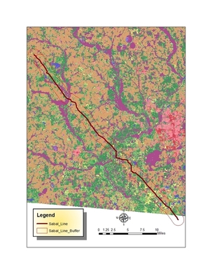
Brooks and Lowndes Counties, GA This digitizaiton is thanks to Continue reading