Tag Archives: Grand Bay

Moody AFB F-35A Beddown DEIS 2026-08-21

Moody Air Force Base is expected to host the F-35A Lightning II aircraft. If I am reading the 450-page Draft Environmental Impact Study (DEIS), they expect the new aircraft may be heard somewhat farther afield, but the noise levels will be less.

The DEIS provides a No Action option, which actually is a draconian action: not only not to host the F-3As, but also to stop hosting the A-10C Thunderbolts. Which would mean Moody AFB would have no reason to exist, which the DEIS points out would remove 1,444 jobs from the local economy. Obvious that ain’t gonna happen, because the one thing that unites all the local governments, industry, etc., is keeping Moody AFB.

Nonetheless there is scope for comments on the DEIS. They plan to dig into Mission Bay for a few new physical facilities. What effect will that have, as water from there runs into Grand Bay, down Grand Bay Creek and the Alapahoochee River to the Alapaha and Suwannee Rivers?

What about overflights of Banks Lake?

What about more potential crashes, due to more flights, and PFAS in firefighting foam? That’s what caused the surface and groundwater PFAS contamination reported by Moody AFB in 2016?

https://wwals.net/issues/pfas/

Remember that went down Beatty Branch into Cat Creek and the Withlacoochee River, as well as into the surface water above the Floridan Aquifer.

I’m sure you can find more things to comment on.

[Moody AFB F-35A Beddown, Draft Environmental Impact Study (DEIS), Zoom meeting 2026-09-15, Comment Deadline 2026-09-28]
Moody AFB F-35A Beddown, Draft Environmental Impact Study (DEIS), Zoom meeting 2026-09-15, Comment Deadline 2026-09-28

You can attend a zoom public meeting Tuesday, 15 September 2026, from 6:00 p.m. to 8:00 p.m. (Eastern Time).

https://us06web.zoom.us/j/87029995062?pwd=iVKMSLv3See9eEBJ3fEKWsqnFvGkMt.1

Or send in comments by September 28, 2026, during the zoom meeting, or through an online form.

https://www.moodyafb-f35beddown-eis.com/comment

Or via paper mail to:
Attn: F-35A Beddown EIS
4833 Conti Street, Suite 103
New Orleans LA 70119

https://www.moodyafb-f35beddown-eis.com/_files/ugd/55f3ca_758d79587ce24b93a02c95251a529e03.pdf

Lest you think this is only a local Lowndes County, Georgia, issue, these aircraft will fly as far west as Alabama Continue reading →

Ockolocoochee, Little River 1889-01-29

Who knows the Ockolocoochee River? No, not the Ochlockonee River; that’s a bit to the west.

[Withlacoochee River labeled Suwanee R. in 1823 Irwin and 1834 Lowndes County maps; current WWALS Withlacoochee and Little River Water Trail map]
Withlacoochee River labeled Suwanee R. in 1823 Irwin and 1834 Lowndes County maps; current WWALS Withlacoochee and Little River Water Trail map

You do know the Ockolocoochee River as the Little River, of the Withlacoochee, of the Suwannee.

Here is news from 1889 that also includes the boat that didn’t survive from Troupville to Ellaville, which was apparently not a paddlewheel steamer. Continue reading →

Moody AFB EIS for Comprehensive Airspace Initiative 2023-05-16

WWALS got a paper letter dated May 16, 2023, which says, “The [Department of the Air Force (DAF)] is publishing a Notice of Availablitlity (NOA) in the Federal Register announcing the availability of the Final Environmental Impact Statement for the Comprehensive Airspace Initiative at Moody Air Force Base, Georgia. The publication of the NOA on 19 May 2023 begins a 30-day waiting period that closes on 18 June 2023.”

[Proposed Action & Alternatives, Moody AFB EIS]
Proposed Action & Alternatives, Moody AFB EIS

Apparently you can still send in comments during that 30-day period, but since there has been a long previous public comment period, it does not seem likely many further changes will be made.

All the documents are available from:
https://moodyafbairspaceeis.com/

They are also available Continue reading →

Drainage built over that runs into Grand Bay @ LCC 2022-03-21

This morning the Lowndes County Commission considered and Tuesday evening will vote on letting a subdivision developer replace a detention pond with a built-on lot and some other detention area somewhere unspecified.

[Map: Little Viking Road to Grand Bay, ARWT]
Map: Little Viking Road to Grand Bay, in the WWALS map of the Alapaha River Water Trail (ARWT).

The detention pond is marked by the red ellipse. The most likely drainage from there is where I drew the cyan line. It appears to go into Grand Bay. See below a closeup of the lot and a larger map of how Grand Bay drains into Grand Bay Creek, the Alapahoochee River, the Alapaha River, and then the Suwannee River on the way to the Gulf of Mexico. Continue reading →

Withlacoochee, Alapaha, Suwannee Rivers in GA-EPD Triennial Review Update 2021-09-13

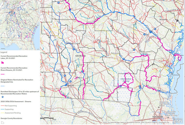
We appear to be the poster child for Recreational redesignation of waterbodies by GA-EPD.

[Prioritization of Nominated Waterbodies]
Prioritization of Nominated Waterbodies; blue marks prioritized waterbodies.

That’s a slide from today’s update meeting.

Not all our blue prioritized waterbodies were redesignated: not Banks Lake nor Grand Bay. But the Withlacoochee and Alapaha segments were redesignated. We may have gotten more river miles redesignated than anywhere else in Georgia.

[Stretches redesignated Recreational]
Stretches redesignated Recreational on the GA-EPD map.

As you can see, GA-EPD stuck to considering swimming as most important for what they call primary recreation, which is what they require for Recreational redesignation. Thanks to all of you who sent in swimming pictures and locations. You can keep sending those in, especially for the Suwannee River. Thanks to those cities and counties and Chambers of Commerce that sent in letters of support. Continue reading →

More Recreational redesignation of waterbodies still possible –GA-EPD 2021-09-01

In addition to the Alapaha and Withlacoochee River segments GA-EPD has accepted to be redesignated Recreational, according to today’s update letter several others still could be considered with certain additional information, and still more can be nominated. This would be for the next Triennial Review of Water Quality Standards, which starts next year, 2022.

Read the whole thing here: PDF.

Excerpts related to the Suwannee River Basin are below. I’ve added a few comments in [square brackets].

The following waterbody segments are being proposed for designated use change to recreation for the 2019 Triennial Review. EPD has received complete nomination packages for each of these waterbody segments, including thorough documentation of year-round primary contact recreation throughout the length of the segment, current and planned investment data, and letters of support from community and stakeholders. A map of these waterbody segments can be found at
https://arcg.is/1i0ezv

[Stretches redesignated Recreational]
Stretches redesignated Recreational on the GA-EPD map.

  • Alapaha River – Cherry Creek to Stateline
  • Alapaha River – Willacoochee River to Dampier Branch
    [Those two Alapaha River stretches omit Sheboggy Boat Ramp downstream from Alapaha, and Lakeland Boat Ramp, Pafford’s Landing, and Rowetown Church Landing downstream from Lakeland.]
  • Withlacoochee River – Tiger Creek to State Line

[Plus Reed Bingham State Park Lake on the Little River was already Recreational, even though it does not appear on the above GA-EPD map. The rest of the Little River we can resubmit.]

Incomplete nomination packages were received for the following waterbodies. EPD will continue to solicit information from the nominators to complete these packages. If EPD receives complete nomination packages, EPD will review the complete packages and consider changing the designated use of these waterbodies to recreation as part of the 2022 Triennial Review:

Missing Documentation of year-round primary contact recreation:

Continue reading →

Parts of Alapaha, Withlacoochee Rivers to be Recreational –GA-EPD 2021-08-11

Update 2021-09-01: More Recreational redesignation of waterbodies still possible –GA-EPD 2021-09-01.

GA-EPD picked a subset of the river stretches they previously said they would consider for Recreational designation: in the Georgia Triennial Review of Water Quality Standards: parts of the Alapaha River, and a smaller part of the Withlacoochee River.

There’s an online Update Meeting next month.

[Header, Suwannee River Basin]
Header, Suwannee River Basin

So that’s the Alapaha River from the Willacoochee River to Dampier Branch, and from Cherry Creek to the state line. I guess you can still paddle from Willacoochee Landing @ GA 135 to Berrien Beach Boat Ramp @ GA 168 without getting into any non-Recreational stretches. But Lakeland Boat Ramp and Pafford’s and Burnt Church Landings are right out. But you can paddle from Hotchkiss Road Landing to Naylor Boat Ramp, Mayday Landing, Statenville Boat Ramp, and on to Florida.

Redesignated Recreational is the Withlacoochee River from Tiger Creek (at Spook Bridge, just below US 84) to the state line. So Knights Creek, Nankin, and State Line Boat Ramps can all be Recreational, even though they’re all downstream of Okapilco Creek and all those cattle in Brooks County, but Langdale Park Boat Ramp and Troupville Boat Ramp are not designated Recreational, despite the Valdosta Mayor’s letter of support.

However, the big win is that anything at all got redesignated. In previous cycles, GA-EPD declined to consider such a thing. And we can reapply next time.

Completely missing from this list are: Continue reading →

Calling for pictures of swimming, diving, rapids, tubing, water skiing, or surfing, Suwannee River Basin, Georgia

Update 2021-06-21: The real deadline is June 30, 2021.

Calling for pictures, personal experience, or other evidence of swimming or diving in lakes and rivers in the Suwannee River Basin, and evidence of investments in recreation.

[Candidate Recreational waterways, Georgia, legend, Suwannee River Basin]
Candidate Recreational waterways, Georgia, legend, Suwannee River Basin

For a waterway to be redesignated Recreational instead of Fishing, as we requested back in 2019, GA-EPD requires evidence of “Primary Contact Recreation,” which it says is “full immersion contact with water where there is significant risk of ingestion that includes, but is not limited to, swimming, diving, white water boating (class 3+), tubing, water skiing, and surfing.”

Recreational designation would mean tighter restrictions on contamination limits. That should be good for fish, fishing, people who swim, fish, and boat, and for eco-tourism.

Could everyone who has pictures, news reports, or other solid evidence of such activities in the Suwannee River Basin in Georgia please send them in. That’s in the Okefenokee Swamp, Suwannee River, Alapaha River, Banks Lake, Grand Bay, Withlacoochee River, or Little River.

Please use this form:
https://forms.gle/DipPgU2TP5atc2Rf9
If you have difficulties with that, please email them to wwalswatershed@gmail.com.

Also, please send any evidence of investments in recreation along any of these waterways, with dollar amounts, if you have them.

No rush. We thought we had until the end of June, but recently GA-EPD truncated the deadline to May 28th. That’s Friday of this week. GA-EPD has indicated that the end-of-week deadline may be flexible, but please send what you’ve got as fast as you can.

They also applied a bunch of criteria, some of which we were previously unaware of, and tossed out many stretches of the rivers. We asked for an appeal process, but they have not provided one. So feel free to send in pictures and other evidence about all stretches, and we’ll see what we can do with them.

The good news is that still on the candidate list for Recreational redesignation is all of the Okefenokee Swamp, the Suwannee River in Georgia, Banks Lake, and Grand Bay Creek and Trail within the Grand Bay WMA. Also included is most of the Alapaha River within the Alapaha River Water Trail, but not upstream from the Willacoochee River, and not for ten miles downstream from Lakeland.

But almost all of the Withlacoochee River is eliminated, except for Tiger Creek (at Spook Bridge) to the state line, and all of the Little River is eliminated. Also gone is Lake Irma, because Continue reading →

Water Trail Brochures available: Alapaha, Withlacoochee, and Little Rivers

WWALS has printed 10,000 z-fold brochures for each of two water trails, through a generous grant from the Georgia Department of Natural Resources (GA-DNR). Plus Georgia Beer Company is a new sponsor, adding to a long list of cities, counties, tourist councils, and development authorities that have assisted with money or letters or resolutions of support. The images here are updated to what we printed. Contact us to get printed copies of these brochures: they’re free to individuals or to groups that will distribute them to the public.

[WLRWT front and back, ARWT mapside]
WLRWT front and back, ARWT mapside

This is the third edition of the Alapaha River Water Trail (ARWT) brochure, and the first-ever Withlacoochee and Little River Water Trail (WLRWT) brochure.

You can help defray the cash match for the grant, online, or contact us. Or maybe you’d like to contribute to our water trail signs.

WWALS is currently updating all our online water trail maps and web pages. You can help:
https://forms.gle/qXkPr7eCK51P4X4u7

There are also many other ways you can participate in the activities and advocacy of WWALS:
https://wwals.net/donations/

Alapaha River Water Trail (ARWT)

See: https://wwals.net/maps/alapaha-water-trail/

The two previous ARWT brochure editions, 10,000 copies each, lasted about four years. This one has Continue reading →

Videos: Suwannee Riverkeeper Songwriting Contest, Wes James, WAAC 92.9 FM 2021-04-20

Wes James brought up a good point last night on the radio. Songwriters, you do not have to sing or play your song, although you do have to be on stage doing something related to the song. So yes, you can get your favorite musicians to sing and play for you, but you do have to be present to win.

Remember to send in your song:
https://wwals.net/pictures/2021-08-21–songwriting Continue reading →