
Update again 2017-03-13:
- Gum Springs 3,000 feet from Sabal Trail and lower flow @ WWALS 2017-02-07
- Sabal Trail hydrostatic test pond at I-75 @ WWALS 2017-02-07
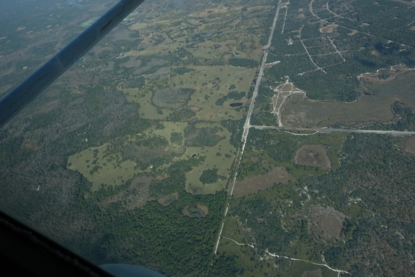
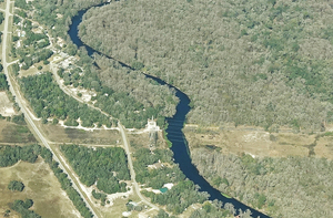
Sabal Trail north from I-75 to the Withlacoochee (south) River.

Photo: Mark Skogman for WWALS on Southwings flight 2017-02-07
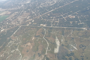
The Villages is about six miles northeast of where Sabal Trail crosses I-75 just north of FL-44.

Photo: Jim Tatum for WWALS on Southwings flight 2017-02-07
Many more pictures below, and a Google Map showing the locations.
-jsq, John S. Quarterman, Suwannee RIVERKEEPER®
You can join this fun and work by becoming a WWALS member today!
Pictures
I-75, FL Turnpike, FL-44, Three Flags RV Compound, 1657-PL-DG-70197-425, 28.8600670, -82.0835380


Little Jones Creek, FL-44, I-75, 28.8664620, -82.0972440

Pilot Travel Center, 493 FL-44, Wildwood, FL 34785, I-75, 28.8726820, -82.0958560

Tommys Tire Shop, 418 FL-44, Wildwood, FL 34785, 28.8773790, -82.0964740

8726 Co Rd 231, Wildwood, FL 34785, 28.8834530, -82.1074560

CR 472, CR 475, SUMTER COUNTY, FLORIDA, 28.8952480, -82.1191310

Closer to CR 472, CR 475, 28.8945140, -82.1199630
Electrical substation, 9760 County Rd 475, Wildwood, FL 34785, 28.8981370, -82.1207250


1936 NW 102nd Blvd, Wildwood, FL 34785, 28.9099880, -82.1338670

NE across Marion Oaks, FL, 28.9772680, -82.2260930

956 NW 102nd Blvd, Wildwood, FL 34785, 28.9151070, -82.1403370

Around Marion Oaks, FL, 28.9601850, -82.2194190
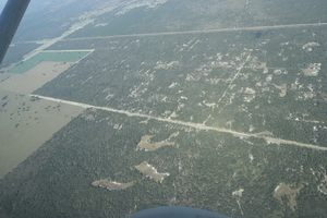
Gum Springs
In the lower left of this picture is Marion Oaks Golf Course,
and on its left edge is Gum Springs, about 3,000 feet from Sabal Trail:
Follow this link for the interactive google map, or it’s also embedded below.
Thanks to Linda Bystrak for noticing that proximity. She wrote:
Your aerial pictures show it very close to Gum Springs next to Marion Oaks golf course. SWFWMD just approved a 3% reduction in flow of that spring last year. Hope the pipe doesn’t change the hydrology of the area. It is surrounded by wetlands and is a popular hunting area.Dan Hilliard and I were at the SWFWMD public meeting last year to speak against the withdrawal. Sorry I can’t remember the date. SWFWMD also has plans to withdraw 25mgd near the intersection of Gum Slough springs and the Withlacoochee. I don’t believe the pipe crosses the Withlacoochee.
The entire area around Wildwood is scheduled for massive new housing developments. Coleman Prison is nearby, but it now has a huge solar array powering it! Sumter Co. government is pretty much run by The Villages, which already has 113,000 residents. The pipeline will be in the center of all the growth in that area.
ST-Flight-pondsink Sinkhole SW of Marion Oaks, 28.9580440, -82.2155150

6000 SW 160th St, Dunnellon, FL 34432, 28.9891740, -82.2201440

SW across 856 Marion Oaks Ln, Ocala, FL 34473, 28.9684760, -82.2065680
E across Rocking F Ranch, 5930 SW 172nd Loop, Ocala, FL 34473, 28.9769030, -82.2285600
Top half right: Sunrise Elementary School, 375 Marion Oaks Course, Ocala, FL 34473, 29.0054970, -82.1971090


8001 SW 160th St, Dunnellon, FL 34432, 28.9890960, -82.2571670

8500 SW 160th St, Dunnellon, FL 34432, 28.9885800, -82.2645450

From 8288 SW 160th St, Dunnellon, FL 34432, W. up Sabal Trail to Halpata Tastanaki, 28.9897648, -82.2596105
9621 SW 160th St, Dunnellon, FL 34432, 28.9891920, -82.2809710

Andrea Rea, 15975 SW 110th Ave, Dunnellon, FL 34432, 28.9852080, -82.2969330

15198 SW 110th Ave, Dunnellon, FL 34432, to FL-200, 28.9961880, -82.3054450

10500 SW 160th St, Dunnellon, FL 34432, 28.9888780, -82.2954130

10998 SW 157th Ln, Dunnellon, FL 34432, 28.9931330, -82.3038030

Reds Restaurant, 8411 N Carl G Rose Hwy, Hernando, FL 34442, Withlacoochee (south) River, Halpata Tastanaki, 28.9856440, -82.3520310

HDD, Withlacoochee (South) River, 28.9906270, -82.3589630

4593 E Spruce Dr, Dunnellon, FL 34434, 28.9916590, -82.3578090
Closeup, Withlacoochee (South) River crossing, 28.9921740, -82.3573500
Google Map
Follow this link for the interactive google map, or it’s also embedded below.
Short Link:
Please check the MFL levels for Gum Slough Springs. I was told by a SWFWMD employee at the recent Rainbow Springs MFL meeting that the MFL was set at 9 % for Gum Slough Springs. I did find this Minimum Flows for Gum Slough Spring Run Addendum resource from October, 2016 (https://www.swfwmd.state.fl.us/projects/mfl/reports/GumSprings/FinalAddendum-Gum_Slough_Spring_Run-Appendices.pdf):
CHAPTER 7 – CONCLUSION
Because the original minimum flows analyses for Gum Slough Spring Run described in a 2011
revised report were based on a relatively short flow record, a decision was made to gather more
information to support more robust minimum flow recommendations for the system. The flow
record was increased from seven to ten years, and the previously peer-reviewed analyses used
for the original minimum flows determination were repeated.
Results of the new analyses yielded an updated minimum flow recommendation that would allow
up to a six percent reduction in flows due to water withdrawals, based on a potential 15 percent
decrease of available habitat for adult spotted sunfish in the spring run. The updated minimum
flow recommendation also includes the recommended stipulation that surface water withdrawals
are prohibited from depressing flows below 43 cfs. The adopted minimum flow will be reevaluated
within ten years.
Updated groundwater modeling results indicated that the predicted streamflow decline for Gum
Slough Spring Run at the USGS Gum Springs near Holder gage site under current pumping
conditions is approximately 3.4 percent. Based on this information, a recovery strategy is not
required for the proposed minimum flows.
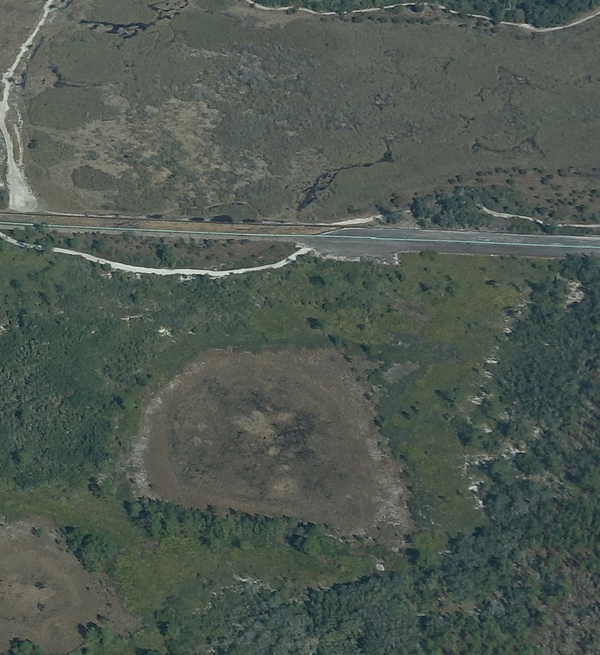
Look at the first photo – “Sabal Trail north from I-75 to the Withlacoochee (south) River.” This shows the hydrostatic discharge point for Spread 5 (at least the site they reported that they will use) and the withdrawal point for Spread 6. Coordinates are: 28°52’47.99″N, 82° 5’39.69″W
Also, they show 9,710,000 gallons being discharged into this pond for Spread 5 and 7,200,000 gallons being withdrawn from this pond for Spread 6 hydrostatic testing. The Maximum Discharge Rate (gallons per minute) for these activities is 9,000 gallons per minute. Source: Resource Report 2, Water Use and Quality, Table 2.3-10 (November, 2014).
Does anyone have any new information about their hydrostatic testing water withdrawals and discharges? 9,710,000 gallons equals 30 acre-feet of water. This is about a 5-6 acre pond. Maximum discharge rate of 9,000 gallons per minute is quite a bit of force.
What are their other sites for other Spreads? Have they been investigating alternative sites? If so, where? How long does it take to expel the water from each test?
Pingback: Sabal Trail hydrostatic test pond at I-75 @ WWALS 2017-02-07 | WWALS Watershed Coalition (Suwannee RIVERKEEPER®)
Pingback: Gum Springs 3,000 feet from Sabal Trail and lower flow @ WWALS 2017-02-07 | WWALS Watershed Coalition (Suwannee RIVERKEEPER®)