Tag Archives: Aerials

USACE has miners explain equipment on yard near St. George, GA 2019-10-18

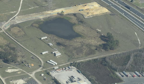
Our Suwannee Riverkeeper Southwings flight of October 5, 2019, caused the U.S. Army Corps of Engineers to demand Twin Pines Minerals explain their equipment site on pain of civil or criminal penalties.

[Dragline Yard Location Map]
Dragline Yard Location Map
PDF

The Corps’ Holly Ross wrote on October 9, 2019 (see also PDF): :

We received a tip that Twin Pines had started work on the project site. The WWALS has aerial imagery posted on their site of mining equipment staged. Continue reading

Aerials: Sabal Trail hydrostatic test pond at I-75 @ WWALS 2017-02-07

Good questions by Janet Barrow. Who has answers?

Janet Barrow
March 13, 2017 at 4:55 pm

Look at the first photo — “Sabal Trail north from I-75 to the Withlacoochee (south) River.” This shows the hydrostatic discharge point for Spread 5 (at least the site they reported that they will use) and the withdrawal point for Spread 6. Coordinates are: 28°52’47.99″N, 82°5’39.69″W

Thanks to Mark Skogman’s long lens on the Southwings flight for WWALS, we can zoom in on that spot.

Hydrostatic test pond at I-75

Janet Barrow
March 13, 2017 at 5:07 pm

Continue reading

Aerials: I-75 to Withlacoochee (south) River 2017-02-07

Update again 2017-03-13:

Sabal Trail north from I-75 to the Withlacoochee (south) River.

Tommys Tire Shop, 418 FL-44, Wildwood, FL 34785,
Photo: Mark Skogman for WWALS on Southwings flight 2017-02-07

The Villages is about six miles northeast of where Sabal Trail crosses I-75 just north of FL-44.

Closeup, Withlacoochee (South) River crossing,
Photo: Jim Tatum for WWALS on Southwings flight 2017-02-07

Many more pictures below, and a Google Map showing the locations.

 -jsq, John S. Quarterman, Suwannee RIVERKEEPER®

You can join this fun and work by becoming a WWALS member today!

Pictures

Continue reading