
The south end of Sabal Trail connects its Hunters Creek Pipeline, running through many wetlands and past many subdivisions and malls through Davenport and Kissimmee to connect to Florida Gas Transmission (FGT) just west of Florida’s Turnpike. This is all about six miles south and east of Disney World.

NW past Central Florida Pipeline Corp. to Reunion Compressor Station, 6781 Osceola Polk Line Rd, Davenport, FL 33896, 28.2610489, -81.5572004
Here are aerials taken by Mark Skogman on a Southwings flight for WWALS 7 February 2017, piloted by Roy Zimmer. Also on the plane were Andrea Rea and Jim Tatum. And there’s a google map.
-jsq, John S. Quarterman, Suwannee RIVERKEEPER®
You can join this fun and work by becoming a WWALS member today!
Pictures
Click on any small picture for a larger one.
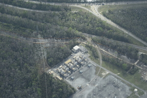
WSW across Reunion Compressor Station, 28.2633570, -81.5523430


WSW across Central Florida Pipeline Corporation, 6525 Osceola Polk Line Rd, Davenport, FL 33896, to Reunion Compressor Station, 28.2663060, -81.5411700

WSW down Sabal Trail and US 17, 28.2642390, -81.5370800

WNW across West Orange Blossom Trail (US 17) and Sabal Trail, 6272 S Orange Blossom Trail, Davenport, FL 33896

Sabal Trail silt fence N of Osceola Polk Line Road and US 17, 28.2599270, -81.5431460
SE across power substation, Sabal Trail, RR, Osceola Polk Line Rd, 28.2624690, -81.5456140

SE across water reflecting, Sabal Trail, RR, Osceola Polk Line Rd, US 17, 28.2628000, -81.5451740

NW across US 192, 4677 W Irlo Bronson Memorial Hwy, 28.3205130, -81.4656520
NW across Nike Clearance Store, 2573 Old Vineland Rd, Kissimmee, FL 34746, 28.3182780, -81.4672050

WNW up 4774 Quemar Dr, Kissimmee, FL 34746 to Siesta Laga Drive STT corner, 28.3181360, -81.4741560

WNW across STT, N Poinciana Blvd, Osceola County Fire Rescue Station 42, 28.3093210, -81.4762180
STT equipment E of N Poinciana Blvd, 28.3108320, -81.4786960

NNW across Osceola County Fire Rescue Station to 5005 Laguna Bay Cir, Kissimmee, FL 34746, 28.3117850, -81.4838510
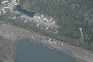
W across STT silt fence on canal by Pine Island, 28.3028400, -81.4906100

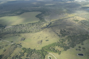
WNW across STT silt fence S of Pine Island, 28.2927180, -81.4975460

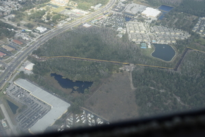
NW above Cabage Island to STT to Buckles Bend, 28.2881360, -81.5058610

W from 1301 Wooten Rd, Davenport, FL 33896 to KUA Cane Island Power Plant, 28.2767011, -81.5334131

W to silt fence past 1301 Wooten Rd, Davenport, FL 33896, 28.2770600, -81.5165040

KUA Cane Island Power Plant, Bobroff Road, Kissimmee, FL 34758, 28.2746506, -81.5308592

1325 Wooten Rd, Davenport, FL 33896, 28.2728490, -81.5199940

NW from Old Tampa Hwy up Bobroff Rd to KUA Cane Island Power Plant, 28.2675480, -81.5250470

NW from Poinciana Towing & Recovery Inc., 6091 Old Tampa Hwy Davenport, FL 33896, 28.2662770, -81.5273560

N from 6091 Old Tampa Hwy, Davenport, FL 33896 to KUA Cane Island Power Plant, 28.2669081, -81.5289433
Skogman-01-024

NW past Central Florida Pipeline Corp. to Reunion Compressor Station, 6781 Osceola Polk Line Rd, Davenport, FL 33896, 28.2610489, -81.5572004

Begin Hunters Creek Pipeline at Reunion Compressor Station past Central FL Pipeline Corp., 28.2628850, -81.5539910

STT in front of Central FL Pipeline Corp, 28.2606640, -81.5467220
NW across Reunion Compressor Station from Ace Wrecker Service, 6671 Osceola Polk Line Rd, Davenport, FL 33896, 28.2600212, -81.5540972

Google Map
Follow this link for the interactive google map, or it’s also embedded below.
Short Link:
Pingback: Protests across Florida against Sabal Trail, which is worse than reporters think | WWALS Watershed Coalition (Suwannee RIVERKEEPER®)